File:1946 Iejima Airfield.png
Jump to navigation
Jump to search

Size of this preview: 800 × 396 pixels. Other resolutions: 320 × 158 pixels | 640 × 317 pixels | 1,024 × 507 pixels | 1,959 × 969 pixels.
Original file (1,959 × 969 pixels, file size: 1.91 MB, MIME type: image/png)
Captions
Captions
Add a one-line explanation of what this file represents
Summary[edit]
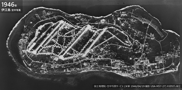
| Description |
日本語: 米軍伊江島飛行場 (1946年) |
| Date | |
| Source | 国土地理院地図・空中写真閲覧サービス |
| Author | 国土地理院・空中写真サービス (米軍 1946/04/19 撮影 USA-M57-27) を切りだし加工 |
Licensing[edit]

|
The copyright holder of this file, Ministry of Land, Infrastructure, Transport and Tourism, allows anyone to use it for any purpose, provided that the copyright holder is properly attributed. Redistribution, derivative work, commercial use, and all other use is permitted. |
Attribution:
National Land Image Information (Color Aerial Photographs), created by Ministry of Land, Infrastructure, Transport and Tourism, distributed by Geospatial Information Authority of Japan
|

File history
Click on a date/time to view the file as it appeared at that time.
| Date/Time | Thumbnail | Dimensions | User | Comment | |
|---|---|---|---|---|---|
| current | 23:42, 26 February 2023 | | 1,959 × 969 (1.91 MB) | Alain Parks (talk | contribs) | Uploaded a work by 国土地理院・空中写真サービス (米軍 1946/04/19 撮影 USA-M57-27) を切りだし加工 from 国土地理院地図・空中写真閲覧サービス with UploadWizard |
You cannot overwrite this file.
File usage on Commons
There are no pages that use this file.
File usage on other wikis
The following other wikis use this file:
- Usage on ja.wikipedia.org