File:1967 Six Day War - Battle of Golan Heights.svg
跳至導覽
跳至搜尋

此 SVG 檔案的 PNG 預覽的大小:613 × 599 像素。 其他解析度:245 × 240 像素 | 491 × 480 像素 | 785 × 768 像素 | 1,047 × 1,024 像素 | 2,094 × 2,048 像素 | 904 × 884 像素。
原始檔案 (SVG 檔案,表面大小:904 × 884 像素,檔案大小:412 KB)
說明
說明
添加單行說明來描述出檔案所代表的內容
| 描述 |
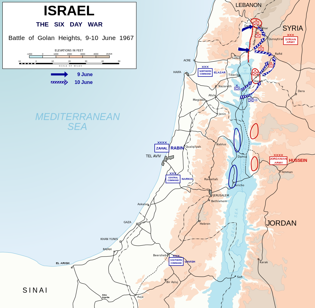
English: Map depicting battle of Golan Heights (9-10 June, 1967) during Six-Day War. Symbols used in the map are NATO military symbols.
Català: Mapa que mostra la batalla dels Alts del Golan (9-10 de juny, 1967) durant la Guerra dels Sis Dies. Els símbols que s'utilitzen al mapa són els símbols militars de l'OTAN. |
| 日期 | (UTC) |
| 來源 | |
| 作者 | Honza Havlíček |
| 其他版本 |
|


| 我,此作品的版權所有人,釋出此作品至公共領域。此授權條款在全世界均適用。 這可能在某些國家不合法,如果是的話: 我授予任何人有權利使用此作品於任何用途,除受法律約束外,不受任何限制。 |
檔案歷史
點選日期/時間以檢視該時間的檔案版本。
| 日期/時間 | 縮圖 | 尺寸 | 用戶 | 備註 | |
|---|---|---|---|---|---|
| 目前 | 2023年9月29日 (五) 23:12 | | 904 × 884(412 KB) | Joutbis(對話 | 貢獻) | File uploaded using svgtranslate tool (https://svgtranslate.toolforge.org/). Added translation for ca. |
| 2009年11月19日 (四) 21:43 |  | 904 × 884(373 KB) | Honza.havlicek(對話 | 貢獻) | {{Information |Description={{en|1=Map depicting battle of Golan Heights (9-10 June, 1967) during Six-Day War. Symbols used in the map are {{w|NATO_map_symbols|NATO military symbols}}.}} |Source=*Israel 1949-1967.svg *[[:File |
無法覆蓋此檔案。
檔案用途
下列7個頁面有用到此檔案:
- 1967
- User:Magog the Ogre/Maps of conflicts/2023 September
- User:Magog the Ogre/Multilingual legend/2023 September 26-30
- File:1967 Six Day War - Battle of Golan Heights-es.svg
- File:1967 Six Day War - Battle of Golan Heights.jpg
- File:1967 Six Day War - Battle of Golan Heights.svg
- File:Battle of Golan Heights-hu.svg
全域檔案使用狀況
以下其他 wiki 使用了這個檔案:
- af.wikipedia.org 的使用狀況
- azb.wikipedia.org 的使用狀況
- az.wikipedia.org 的使用狀況
- ca.wikipedia.org 的使用狀況
- cs.wikipedia.org 的使用狀況
- da.wikipedia.org 的使用狀況
- de.wikipedia.org 的使用狀況
- en.wikipedia.org 的使用狀況
- eo.wikipedia.org 的使用狀況
- eu.wikipedia.org 的使用狀況
- fi.wikipedia.org 的使用狀況
- id.wikipedia.org 的使用狀況
- it.wikipedia.org 的使用狀況
- ja.wikipedia.org 的使用狀況
- krc.wikipedia.org 的使用狀況
- lv.wikipedia.org 的使用狀況
- nl.wikipedia.org 的使用狀況
- no.wikipedia.org 的使用狀況
- pl.wikipedia.org 的使用狀況
- ru.wikipedia.org 的使用狀況
- sk.wikipedia.org 的使用狀況
- sq.wikipedia.org 的使用狀況
- sr.wikipedia.org 的使用狀況
- th.wikipedia.org 的使用狀況
- tr.wikipedia.org 的使用狀況
- uk.wikipedia.org 的使用狀況
- vi.wikipedia.org 的使用狀況
- zh.wikipedia.org 的使用狀況