File:1972 Summit Series plaque at Maple Leaf Gardens, Toronto (Historic Sites and Monuments Board of Canada and Parks Canada).jpg
Jump to navigation
Jump to search

Size of this preview: 450 × 600 pixels. Other resolutions: 180 × 240 pixels | 360 × 480 pixels | 576 × 768 pixels | 768 × 1,024 pixels | 1,536 × 2,048 pixels | 3,306 × 4,408 pixels.
Original file (3,306 × 4,408 pixels, file size: 3.51 MB, MIME type: image/jpeg)
Captions
Captions
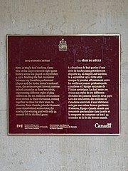
1972 Summit Series plaque at Maple Leaf Gardens, Toronto (Historic Sites and Monuments Board of Canada and Parks Canada)
Summary
[edit].jpg&action=edit§ion=1)
| Description |
English: 1972 SUMMIT SERIES Here, at Maple Leaf Gardens, Game Two of this unprecedented eight-game hockey series was played on September 4, 1972. Marking the first encounter between top Canadian professional players and the Soviet Union's national team, the series aroused fervent passions in both countries as these two rivals, representing different styles of play, clashed on the ice. Millions of Canadians were riveted to their televisions, coming together to cheer for their team. In Moscow, Team Canada gained a dramatic come-from-behind series victory by scoring the winning goal with only 34 seconds left in the final game. Historic Sites and Monuments Board of Canada and Parks Canada
- Maple Leaf Gardens - 50 Carlton Street, Toronto, ON M5B 1J2, Canada
Français : LA SÉRIE DU SIÈCLE La deuxième de huit parties d'une série de hockey sans précédent est. disputée ici, au Maple Leaf Gardens, le 4 septembre 1972. Cette série marque le premier affrontement entre les meilleurs joueurs professionnels canadiens et l'équipe nationale de l'Union soviétique. Le duel entre ces rivaux aux styles de jeu différents déchaîne les passions dans les deux pays. Lors des rencontres, des millions de Canadiens sont rivés à leur téléviseur, unis par une même ferveur partisane. A Moscou, Équipe Canada réussit une remontée spectaculaire dans la série et la remporte en comptant un but à 34 secondes de la fin du dernier match. Commission des lieux et monuments historiques du Canada et Parcs Canada
- Maple Leaf Gardens - 50 Carlton Street, Toronto, ON M5B 1J2, Canada |
| Date | |
| Source | Own work |
| Author | Spudgun67 |
| Camera location | | View this and other nearby images on: OpenStreetMap |
|---|
.jpg¶ms=043.661869_N_-079.379876_E_globe:Earth_type:camera__&language=en)
Licensing
[edit].jpg&action=edit§ion=2)
I, the copyright holder of this work, hereby publish it under the following license:
This file is licensed under the Creative Commons Attribution-Share Alike 4.0 International license.
- You are free:
- to share – to copy, distribute and transmit the work
- to remix – to adapt the work
- Under the following conditions:
- attribution – You must give appropriate credit, provide a link to the license, and indicate if changes were made. You may do so in any reasonable manner, but not in any way that suggests the licensor endorses you or your use.
- share alike – If you remix, transform, or build upon the material, you must distribute your contributions under the same or compatible license as the original.
File history
Click on a date/time to view the file as it appeared at that time.
| Date/Time | Thumbnail | Dimensions | User | Comment | |
|---|---|---|---|---|---|
| current | 09:23, 15 March 2020 | | 3,306 × 4,408 (3.51 MB) | Spudgun67 (talk | contribs) | Uploaded own work with UploadWizard |
You cannot overwrite this file.
File usage on Commons
There are no pages that use this file.
File usage on other wikis
The following other wikis use this file:
- Usage on en.wikipedia.org
.jpg&oldid=828604072)