File:1te Vesta-Expedition.png
Jump to navigation
Jump to search

Size of this preview: 589 × 599 pixels. Other resolutions: 236 × 240 pixels | 472 × 480 pixels | 755 × 768 pixels | 1,006 × 1,024 pixels | 1,772 × 1,803 pixels.
Original file (1,772 × 1,803 pixels, file size: 313 KB, MIME type: image/png)
Captions
Captions
Add a one-line explanation of what this file represents
Summary
[edit]
| Description |
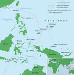
Deutsch: Karte zur ersten Vesta-Expedition Alfred Tetens’, Aug. 1865–Sept. 1866 (zeitgenössische Benennungen). Die Namen von Inselgruppen, Atollen, Inseln und Orten sind die im 19. Jahrhundert in Deutschland gebräuchlichen. Die Schreibweise orientiert sich an Tetens' Expeditionsberichten. PNG-Version zur Einbindung in Artikel. |
| Date | |
| Source | Kartendaten: Demis Map Server und Karte „Übersicht der Deutschen Besitzungen im Stillen Ozean“; Projektion: unbekannt; Quelle Benennungen und Reisewege: Alfred Tetens: Expeditionen der Hamburger Brigg Vesta: Die Berichte von Kapitän Alfred Tetens, 1865–1868. Transcript in modern German script by Jakob Anderhandt of Captain Tetens’ reports of his expeditions to the Caroline Islands and Palau, with annotations. (Transkript der Berichte von Alfred Tetens über seine Expeditionen zu den Karolinen und nach Palau, 1865–1868, in lateinischer Schrift, angefertigt, mit Anmerkungen versehen von Jakob Anderhandt.) Australian National University (Pacific Manuscripts Bureau), Canberra 2009. Mikrofilm, PMB 1319; erstellt mit: Adobe Illustrator, CS 2. |
| Author | Mr Südsee at German Wikipedia |
| Other versions | PDF-Version mit allen Bearbeitungsfunktionen |
Licensing
[edit]
| This work has been released into the public domain by its author, Mr Südsee at German Wikipedia. This applies worldwide. In some countries this may not be legally possible; if so: Mr Südsee grants anyone the right to use this work for any purpose, without any conditions, unless such conditions are required by law. |
Original upload log
[edit]
Transferred from de.wikipedia to Commons by NordNordWest using CommonsHelper.
The original description page was here. All following user names refer to de.wikipedia.
- 2013-07-24 00:50 Mr Südsee 1772×1803× (320873 bytes) == Beschreibung, Quelle == {{Information |Beschreibung = Karte zur ersten Vesta-Expedition Alfred Tetens’, Aug. 1865–Sept. 1866 (zeitgenössische Benennungen). PNG-Version zur Einbindung in Artikel. |Quelle = Kartendaten: Demis Map Se…
File history
Click on a date/time to view the file as it appeared at that time.
| Date/Time | Thumbnail | Dimensions | User | Comment | |
|---|---|---|---|---|---|
| current | 07:34, 17 September 2013 | | 1,772 × 1,803 (313 KB) | File Upload Bot (Magnus Manske) (talk | contribs) | Transfered from de.wikipedia by User:NordNordWest using CommonsHelper |
You cannot overwrite this file.
File usage on Commons
There are no pages that use this file.
File usage on other wikis
The following other wikis use this file:
- Usage on de.wikipedia.org