File:2006 Existing Conditions Plan, Channing Way to Durant Avenue - Piedmont Way and the Berkeley Property Tract, East of College Avenue between Dwight Way and U.C. Memorial HALS CA-2 (sheet 4 of 5).png

Original file (14,400 × 9,600 pixels, file size: 3.62 MB, MIME type: image/png)
Captions
Captions
| This image is a JPEG version of the original TIF image at File: 2006 Existing Conditions Plan, Channing Way to Durant Avenue - Piedmont Way and the Berkeley Property Tract, East of College Avenue between Dwight Way and U.C. Memorial HALS CA-2 (sheet 4 of 5).tif.
However, any edits to the image should be based on the original TIF version in order to prevent generation loss, and both versions should be updated. Do not make edits based on this version. |
Summary[edit]
| Warning | The original file is very high-resolution. It might not load properly or could cause your browser to freeze when opened at full size. |
|---|
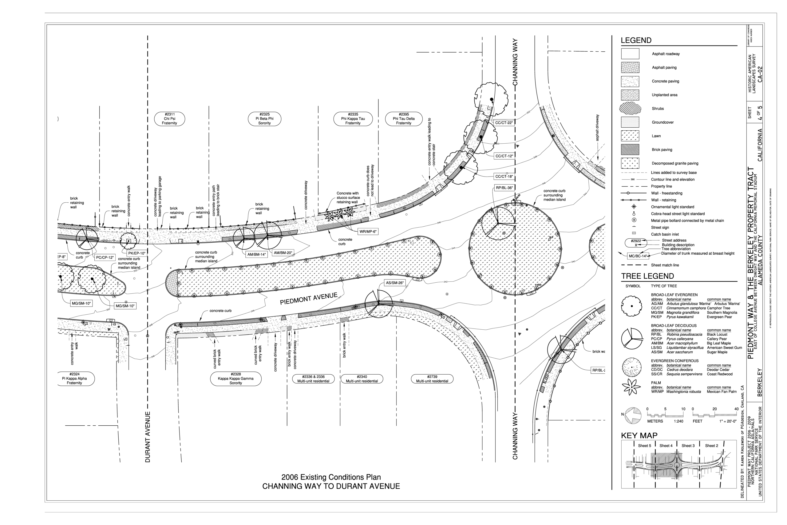
| 2006 Existing Conditions Plan, Channing Way to Durant Avenue - Piedmont Way and the Berkeley Property Tract, East of College Avenue between Dwight Way and U.C. Memorial Stadium, Berkeley, Alameda County, CA | ||||
|---|---|---|---|---|
| Photographer |
PGAdesign Related names:
|
|||
| Title |
2006 Existing Conditions Plan, Channing Way to Durant Avenue - Piedmont Way and the Berkeley Property Tract, East of College Avenue between Dwight Way and U.C. Memorial Stadium, Berkeley, Alameda County, CA |
|||
| Depicted place | California; Alameda County; Berkeley | |||
| Date | 2006 | |||
| Current location |
Library of Congress Prints and Photographs Division Washington, D.C. 20540 USA http://hdl.loc.gov/loc.pnp/pp.print |
|||
| Accession number |
HALS CA-2 (sheet 4 of 5) |
|||
| Credit line |
|
|||
| Notes |
The design work that he did for the Berkeley Property Tract, i.e., the design of the campus, residential area, and roadways curved to the topography, is significant in its own right. The alignment of the roads, the shape of the residential blocks, the relationship of the private blocks to each other, and the opportunities for healthful views and walking outings are all representative of Olmsted’s civic and design principles. (Hallinan: 2004, 28) The written Olmsted report to the Trustees accompanying his design provides his vision for the property. These significant design details and ideas would go on to inform his subsequent work in New York. This is particularly important in his most well known suburban developments, Riverside, Illinois and Druid Hills, Georgia. The ideas of broad roadways, curved to the terrain, separated or controlled access roads, curved lot lines, views and vistas and tree-lined spaces, including parks, and recreational areas were new to the thinking of town planning. He was no doubt familiar with Llewellyn Park, laid out by Alexander Jackson Davis or possibly even Glendale, Ohio (1851) also laid out with a curving pattern of streets shaped to the topography as well as with London examples by John Nash and James Pennethorn. Many of the cities in Olmsted’s east coast experience had been laid out on the grid pattern with simple square open spaces, such as New Haven, where he attended Yale for a period. He lived in San Francisco when he first came to California and was thus very familiar with a rigid grid street pattern overlaid on the very hilly terrain. He broke from such molds to establish new models designed to enhance the lives of the residents of these newly planned communities.
|
|||
| Source | https://www.loc.gov/pictures/item/ca3441.sheet.00004a | |||
| Permission (Reusing this file) |
|
|||
| Other versions |
.png) .png) .png) .png) |
|||

.png&action=edit§ion=1)
| Object location | | View this and other nearby images on: OpenStreetMap |
|---|
.png¶ms=037.871670_N_-122.271670_E_globe:Earth_class:object_type:object__&language=en)
File history
Click on a date/time to view the file as it appeared at that time.
| Date/Time | Thumbnail | Dimensions | User | Comment | |
|---|---|---|---|---|---|
| current | 19:11, 7 July 2014 | | 14,400 × 9,600 (3.62 MB) | Faebot (talk | contribs) | {{Compressed version|file=File:2006_Existing_Conditions_Plan,_Channing_Way_to_Durant_Avenue_-_Piedmont_Way_and_the_Berkeley_Property_Tract,_East_of_College_Avenue_between_Dwight_Way_and_U.C._Memorial_HALS_CA-2_(sheet_4_of_5).tif|thumb=nothumb}} =={{int... |
You cannot overwrite this file.
File usage on Commons
The following 10 pages use this file:
- File:2006 Existing Conditions Plan, Channing Way to Durant Avenue - Piedmont Way and the Berkeley Property Tract, East of College Avenue between Dwight Way and U.C. Memorial HALS CA-2 (sheet 4 of 5).png
- File:2006 Existing Conditions Plan, Channing Way to Durant Avenue - Piedmont Way and the Berkeley Property Tract, East of College Avenue between Dwight Way and U.C. Memorial HALS CA-2 (sheet 4 of 5).tif
- File:2006 Existing Conditions Plan, Durant Avenue to Bancroft Way - Piedmont Way and the Berkeley Property Tract, East of College Avenue between Dwight Way and U.C. Memorial HALS CA-2 (sheet 5 of 5).png
- File:2006 Existing Conditions Plan, Durant Avenue to Bancroft Way - Piedmont Way and the Berkeley Property Tract, East of College Avenue between Dwight Way and U.C. Memorial HALS CA-2 (sheet 5 of 5).tif
- File:2006 Existing Conditions Plan, Dwight Way to Haste Street - Piedmont Way and the Berkeley Property Tract, East of College Avenue between Dwight Way and U.C. Memorial Stadium, HALS CA-2 (sheet 2 of 5).png
- File:2006 Existing Conditions Plan, Dwight Way to Haste Street - Piedmont Way and the Berkeley Property Tract, East of College Avenue between Dwight Way and U.C. Memorial Stadium, HALS CA-2 (sheet 2 of 5).tif
- File:2006 Existing Conditions Plan, Haste Street to Channing Way - Piedmont Way and the Berkeley Property Tract, East of College Avenue between Dwight Way and U.C. Memorial Stadium HALS CA-2 (sheet 3 of 5).png
- File:2006 Existing Conditions Plan, Haste Street to Channing Way - Piedmont Way and the Berkeley Property Tract, East of College Avenue between Dwight Way and U.C. Memorial Stadium HALS CA-2 (sheet 3 of 5).tif
- File:Piedmont Way and The Berkeley Property Tract Tittle Sheet - Piedmont Way and the Berkeley Property Tract, East of College Avenue between Dwight Way and U.C. Memorial Stadium, HALS CA-2 (sheet 1 of 5).png
- File:Piedmont Way and The Berkeley Property Tract Tittle Sheet - Piedmont Way and the Berkeley Property Tract, East of College Avenue between Dwight Way and U.C. Memorial Stadium, HALS CA-2 (sheet 1 of 5).tif
.png)
.png&oldid=749017810)