File:20080929-laura-full.jpg
跳转到导航
跳转到搜索
本预览的尺寸:494 × 600像素。 其他分辨率:198 × 240像素 | 395 × 480像素 | 633 × 768像素 | 844 × 1,024像素 | 1,687 × 2,048像素 | 6,431 × 7,806像素。
原始文件 (6,431 × 7,806像素,文件大小:34.11 MB,MIME类型:image/jpeg)
说明
说明
添加一行文字以描述该文件所表现的内容
摘要[编辑]
| 描述 |
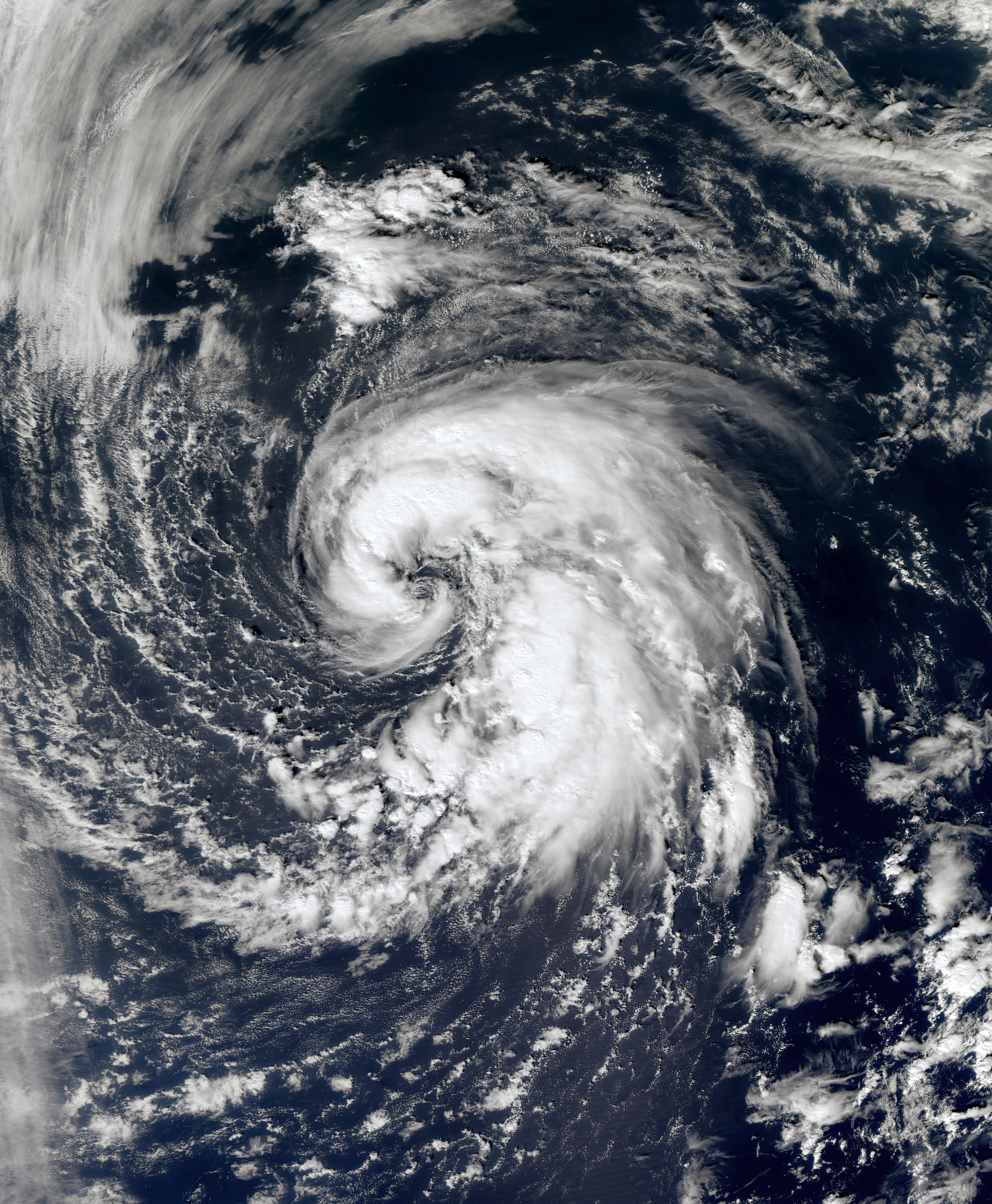
English: In late September, a large non-tropical system located over the north-central Atlantic slowly moved westward away from the Azores. The low produced hurricane-force winds, but did not exhibit the characteristics of a tropical cyclone. The storm steadily weakened over the following days, but developed tropical characteristics as it moved over slightly warmer waters.
By September 29, the low had developed sufficient convection and was declared Subtropical Storm Laura. Upon being upgraded, cold cloud tops began to wrap around the center of Laura and consolidate near the center of circulation. The convection organized around the center quickly and a satellite pass over the storm revealed that it could be intensifying. A later satellite pass disregarded the possibility of intensification as the intensity was confirmed to be at 60 mph (95 km/h). The overall structure of Laura remained subtropical but there were indications that it might have been acquiring tropical characteristics. As of 11 p.m. AST September 29 (0300 UTC September 30), Subtropical Storm Laura is located within 20 nautical miles of 38.3°N 48.4°W, about 585 mi (940 km) south-southeast of Cape Race, Newfoundland and Labrador. Maximum sustained winds are 50 knots (60 mph, 95 km/h), with stronger gusts. Minimum central pressure is 995 mbar (hPa; 29.38 InHg), and the system is moving north at 8 kt (9 mph, 15 km/h). |
| 日期 | |
| 来源 | NASA Worldview |
| 作者 | NASA |
| 授权 (二次使用本文件) |
Public domain |
许可协议[编辑]
| 本文件完全由NASA创作,在美国属于公有领域。根据NASA的版权方针,NASA的材料除非另有声明否则不受版权保护。(参见Template:PD-USGov/zh、NASA版权方针页面或JPL图片使用方针。) | ||
 |
警告:
|
文件历史
点击某个日期/时间查看对应时刻的文件。
| 日期/时间 | 缩略图 | 大小 | 用户 | 备注 | |
|---|---|---|---|---|---|
| 当前 | 2013年4月2日 (二) 11:31 | | 6,431 × 7,806(34.11 MB) | Supportstorm(留言 | 贡献) | Geo-rectify |
| 2013年3月26日 (二) 05:51 |  | 7,329 × 7,915(11.07 MB) | Earth100(留言 | 贡献) | 250 meter res, better quality. |
您不可以覆盖此文件。
文件用途
以下页面使用本文件:
全域文件用途
以下其他wiki使用此文件:
- de.wikipedia.org上的用途
- en.wikipedia.org上的用途
- es.wikipedia.org上的用途
- eu.wikipedia.org上的用途
- ko.wikipedia.org上的用途
- pt.wikipedia.org上的用途
- ru.wikipedia.org上的用途
- uk.wikipedia.org上的用途
- www.wikidata.org上的用途
- zh.wikipedia.org上的用途