File:2008 Sichuan Earthquake aftershockes through May 28.pdf
跳至導覽
跳至搜尋

此 PDF 檔案的 JPG 預覽的大小:463 × 599 像素。 其他解析度:185 × 240 像素 | 371 × 480 像素 | 593 × 768 像素 | 1,275 × 1,650 像素。
原始檔案 (1,275 × 1,650 像素,檔案大小:1.29 MB,MIME 類型:application/pdf)
說明
說明
添加單行說明來描述出檔案所代表的內容
摘要[編輯]
| 描述 |
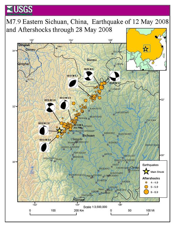
English: Map showing the location of the 2008 Sichuan earthquake and all the aftershocks following it through May 28, 2008 |
| 日期 | |
| 來源 | USGS |
| 作者 | USGS |
| 授權許可 (重用此檔案) |
Public Domain |
授權條款[編輯]
|
|
原始上傳日誌[編輯]
The original description page was here. All following user names refer to en.wikipedia.
- 2008-06-09 20:51 Cyclonebiskit 1275×1650× (1352464 bytes) {{Information |Description=Map showing the location of the 2008 Sichuan eathquake and all the aftershocks following it through May 28, 2008 |Source=[https://earthquake.usgs.gov/eqcenter/eqinthenews/2008/us2008ryan/#summary USGS] |Date=2008-6-1 |Author=USGS
檔案歷史
點選日期/時間以檢視該時間的檔案版本。
| 日期/時間 | 縮圖 | 尺寸 | 用戶 | 備註 | |
|---|---|---|---|---|---|
| 目前 | 2014年4月13日 (日) 21:55 |  | 1,275 × 1,650(1.29 MB) | The Bushranger(對話 | 貢獻) | Transferred from en.wikipedia |
無法覆蓋此檔案。
檔案用途
沒有使用此檔案的頁面。
全域檔案使用狀況
以下其他 wiki 使用了這個檔案:
- en.wikipedia.org 的使用狀況
- fi.wikipedia.org 的使用狀況
- id.wikipedia.org 的使用狀況
- mt.wikipedia.org 的使用狀況
- sh.wikipedia.org 的使用狀況
- sl.wikipedia.org 的使用狀況
- zh.wikipedia.org 的使用狀況