File:2011-02-13-chemin.jpg
跳转到导航
跳转到搜索

本预览的尺寸:800 × 528像素。 其他分辨率:320 × 211像素 | 640 × 423像素 | 1,024 × 676像素 | 1,280 × 845像素 | 2,560 × 1,691像素 | 4,182 × 2,762像素。
原始文件 (4,182 × 2,762像素,文件大小:11.3 MB,MIME类型:image/jpeg)
说明
说明
添加一行文字以描述该文件所表现的内容
摘要[编辑]
| 描述 |
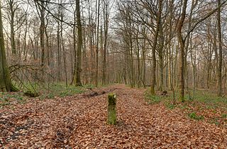
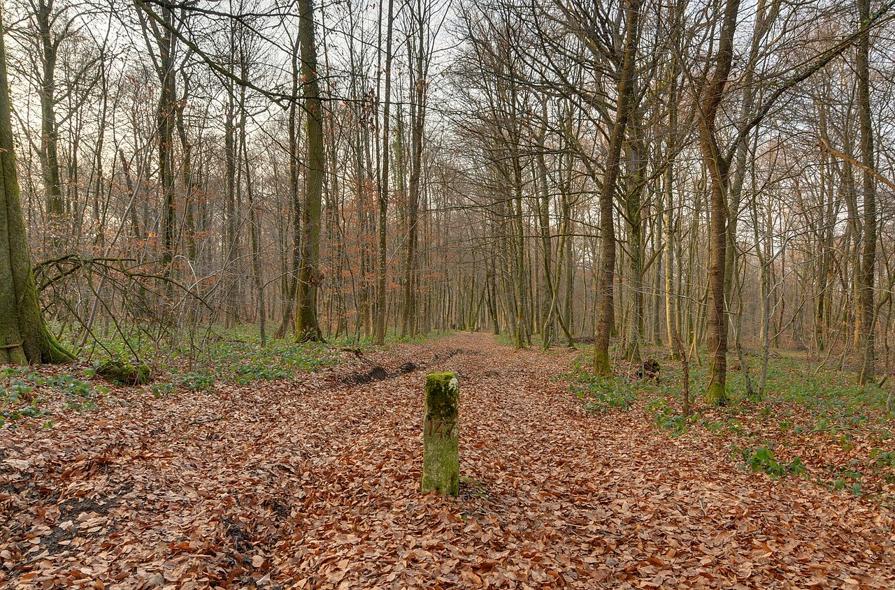
本文件使用Commonist. 该照片用Nikon D300拍摄 Deutsch: Die schweizerisch-französische Grenze zwischen dem Departement Territoire-de-Belfort, Frankreich, und dem Kanton Jura, Schweiz. Auf diesem Bild ist links die Schweiz und rechts Frankreich. Eine zweite Grenzmarkierung ist im Hintergrund sichtbar. Dieses Foto ist ein Hochkontrastbild (HDR). English: The Swiss-French border between the department of Territoire-de-Belfort, France, and the canton of Jura, Switzerland. It is visible in this picture (left Switzerland, right France) – the second boundary marker is visible in the background (HDR) Español: La frontera franco-suiza, entre el cantón del Jura (Suiza, a la izquierda) y el departamento del Territorio de Belfort (Francia, a la derecha). La materializan los dos hitos fronterizos visibles en la foto (el segundo hito es visible en el fondo). (Imagen de gama dinámica amplia) Français : La frontière franco-suisse entre le département du Territoire-de-Belfort, France, et le canton du Jura, Suisse. Elle est matérialisée via les deux bornes frontières visibles sur cette photo (la 2e borne est visible en arrière-plan) (image à grande gamme dynamique). |
||||||||||||||||||||||
| 日期 | |||||||||||||||||||||||
| 来源 | 自己的作品 | ||||||||||||||||||||||
| 作者 |
|
||||||||||||||||||||||

| 相机位置 | | 在以下服务上查看本图像和附近其他图像: OpenStreetMap |
|---|
许可协议[编辑]
本文件采用知识共享署名 3.0 未本地化版本许可协议授权。
- 您可以自由地:
- 共享 – 复制、发行并传播本作品
- 修改 – 改编作品
- 惟须遵守下列条件:
- 署名 – 您必须对作品进行署名,提供授权条款的链接,并说明是否对原始内容进行了更改。您可以用任何合理的方式来署名,但不得以任何方式表明许可人认可您或您的使用。
| 註解 | 該圖片含有註解:在維基媒體共享資源上查看註解 |
评价[编辑]
|
English: The Swiss-French border is visible in this picture (left Switzerland, right France) – the second boundary marker is visible in the background (HDR) 其他语言:
Deutsch: Die französisch-schweizerische Grenze ist auf diesem Bild zu sehen (links Schweiz, rechts Frankreich) – der zweite Grenzstein ist im Hintergrund erkennbar (Hochkontrastbild) Eesti: Prantsusmaa–Šveitsi piir (Šveits vasakul, Prantsusmaa paremal) English: The Swiss-French border is visible in this picture (left Switzerland, right France) – the second boundary marker is visible in the background (HDR) Español: La frontera francosuiza puede verse en esta imagen HDR (Suiza a la izquierda, Francia a la derecha). Un segundo mojón es visible al fondo. Français : La frontière franco-suisse est matérialisée via les deux bornes frontière visible sur cette photo (la 2e borne est visible en arrière-plan) (image à grande gamme dynamique). Italiano: In questa immagine è visibile il confine franco-svizzero, a sinistra la Svizzera a destra la Francia. Un secondo cippo di confine è visibile in lontananza. Nederlands: De te bezoeken grens tussen Zwitserland en Frankrijk (aan de linkerkant Zwitserland, aan de rechterkant Frankrijk). Op de voorgrond een grenspaal. Română: Granița franco-elvețiană se poate vedea în această imagine (stânga Elveția, dreapta Franța) – al doilea marcator de graniță este vizibil în fundal (HDR). Suomi: Sveitsin ja Ranskan välinen valtakunnanraja (vasemmalla Sveitsi, oikealla Ranska) – toinen rajamerkki on nähtävillä taustalla (HDR-kuva). Українська: Швейцарсько-французький кордон (зліва Швейцарія, справа Франція), наступний межевий стовбець видно глибоко на задньому плані (тоноване HDRI зображення). 中文: 瑞士和法国的边界,左边是瑞士,右边是法国。 |
文件历史
点击某个日期/时间查看对应时刻的文件。
| 日期/时间 | 缩略图 | 大小 | 用户 | 备注 | |
|---|---|---|---|---|---|
| 当前 | 2011年2月14日 (一) 17:35 | | 4,182 × 2,762(11.3 MB) | ComputerHotline(留言 | 贡献) |
您不可以覆盖此文件。
文件用途
以下47个页面使用本文件:
- User:ComputerHotline/Archive 4
- User:ComputerHotline/Other
- User:Samsara/POTY 2011 overview
- Commons:Featured picture candidates/File:2011-02-13-chemin.jpg
- Commons:Featured picture candidates/Log/March 2011
- Commons:Featured pictures/Objects
- Commons:Featured pictures/chronological/2011-A
- Commons:Picture of the Year/2011/Galleries/2011-A
- Commons:Picture of the Year/2011/Galleries/A
- Commons:Picture of the Year/2011/Galleries/A/table
- Commons:Picture of the Year/2011/Galleries/ALL
- Commons:Picture of the Year/2011/Galleries/Index/3
- Commons:Picture of the Year/2011/Galleries/Index/ALL
- Commons:Picture of the Year/2011/Galleries/Index/Objects and miscellaneous
- Commons:Picture of the Year/2011/Galleries/MAR
- Commons:Picture of the Year/2011/Galleries/Objects and miscellaneous
- Commons:Picture of the Year/2011/Galleries/Objects and miscellaneous/Large
- Commons:Picture of the Year/2011/Galleries/Objects and miscellaneous/Small
- Commons:Picture of the Year/2011/Galleries/table
- Commons:Picture of the Year/2011/R1/2011-02-13-chemin.jpg
- Commons:Picture of the Year/2011/Results/R1/ALL/table
- Commons:Picture of the Year/2011/Results/R1/Objects and miscellaneous
- Commons:Picture of the Year/2011/Results/R1/Objects and miscellaneous/table
- Commons:Potd/2011-09 (de)
- Commons:Potd/2011-09 (nl)
- Commons:Potd/2011-09 (pt)
- Commons:Quality images/Subject/Places/Mixed/Archive2
- Commons:Quality images candidates/Archives February 2011
- Commons talk:Picture of the Year/2011/Galleries
- Commons talk:Picture of the Year/2011/Results/R1/ALL/table
- Template:Potd/2011-09
- Template:Potd/2011-09-03
- Template:Potd/2011-09-03 (de)
- Template:Potd/2011-09-03 (en)
- Template:Potd/2011-09-03 (es)
- Template:Potd/2011-09-03 (et)
- Template:Potd/2011-09-03 (fi)
- Template:Potd/2011-09-03 (fr)
- Template:Potd/2011-09-03 (hu)
- Template:Potd/2011-09-03 (it)
- Template:Potd/2011-09-03 (ja)
- Template:Potd/2011-09-03 (nl)
- Template:Potd/2011-09-03 (ro)
- Template:Potd/2011-09-03 (ru)
- Template:Potd/2011-09-03 (uk)
- Template:Potd/2011-09-03 (zh-hans)
- Template:Potd/2011-09 (zh-hans)
全域文件用途
以下其他wiki使用此文件:
- ar.wikipedia.org上的用途
- ba.wikipedia.org上的用途
- be-tarask.wikipedia.org上的用途
- bn.wikipedia.org上的用途
- ca.wikipedia.org上的用途
- crh.wikipedia.org上的用途
- cv.wikipedia.org上的用途
- en.wikipedia.org上的用途
- fa.wikipedia.org上的用途
- hu.wikipedia.org上的用途
- kk.wikipedia.org上的用途
- ko.wikipedia.org上的用途
- lbe.wikipedia.org上的用途
- mg.wikipedia.org上的用途
- nn.wikipedia.org上的用途
- nn.wikiquote.org上的用途
- os.wikipedia.org上的用途
- pl.wikipedia.org上的用途
- pt.wikipedia.org上的用途
- rm.wikipedia.org上的用途
- ru.wikipedia.org上的用途
- ru.wikinews.org上的用途
- sah.wikipedia.org上的用途
- sv.wikipedia.org上的用途
- uk.wikipedia.org上的用途
- vi.wikipedia.org上的用途
- xal.wikipedia.org上的用途
- zh.wikipedia.org上的用途