File:2011 Census Scheduled Caste caste distribution map India by state and union territory.svg
Jump to navigation
Jump to search

Size of this PNG preview of this SVG file: 531 × 599 pixels. Other resolutions: 213 × 240 pixels | 425 × 480 pixels | 681 × 768 pixels | 907 × 1,024 pixels | 1,815 × 2,048 pixels | 1,650 × 1,862 pixels.
Original file (SVG file, nominally 1,650 × 1,862 pixels, file size: 1.44 MB)
Captions
Captions
Add a one-line explanation of what this file represents
Summary[edit]
| Description |
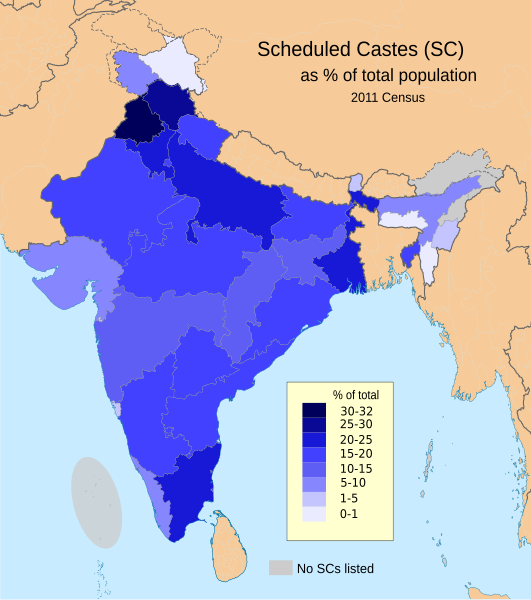
English: This demographic map shows Scheduled Castes (SC, Dalit) as a percent of each state and union territory's population per 2011 Census of India. Punjab had the highest percentage Dalit population in 2011 among all Indian states (31.9%), while Nagaland, Arunachal Pradesh, Andaman & Nicobar Islands and Lakshadweep had 0%.
Source: Census of India 2011, Primary Census Abstract - Scheduled castes and scheduled tribes, Office of the Registrar General & Census Commissioner, India (October 28 2013). The data can be viewed in a Powerpoint presentation on a Government of India Census website here. The disputed national borders SVG code in this map is a derivative work of File:India literacy rate map en.svg available on wikimedia commons. |
| Date | |
| Source | Own work |
| Author | M Tracy Hunter |
Licensing[edit]
I, the copyright holder of this work, hereby publish it under the following license:
This file is licensed under the Creative Commons Attribution-Share Alike 3.0 Unported license.
- You are free:
- to share – to copy, distribute and transmit the work
- to remix – to adapt the work
- Under the following conditions:
- attribution – You must give appropriate credit, provide a link to the license, and indicate if changes were made. You may do so in any reasonable manner, but not in any way that suggests the licensor endorses you or your use.
- share alike – If you remix, transform, or build upon the material, you must distribute your contributions under the same or compatible license as the original.
File history
Click on a date/time to view the file as it appeared at that time.
| Date/Time | Thumbnail | Dimensions | User | Comment | |
|---|---|---|---|---|---|
| current | 19:21, 8 March 2023 | | 1,650 × 1,862 (1.44 MB) | Aishik Rehman (talk | contribs) | File uploaded using svgtranslate tool (https://svgtranslate.toolforge.org/). Added translation for bn. |
| 19:19, 1 June 2020 |  | 1,650 × 1,862 (1.48 MB) | C1MM (talk | contribs) | Coloured island | |
| 19:16, 1 June 2020 |  | 1,650 × 1,862 (1.48 MB) | C1MM (talk | contribs) | Removed fills | |
| 00:03, 22 March 2020 |  | 1,650 × 1,859 (1.91 MB) | C1MM (talk | contribs) | Wording | |
| 00:02, 22 March 2020 |  | 1,650 × 1,859 (1.91 MB) | C1MM (talk | contribs) | Added no SC locations | |
| 22:17, 21 March 2020 |  | 1,650 × 1,859 (1.91 MB) | C1MM (talk | contribs) | Larger version of before file | |
| 22:14, 21 March 2020 |  | 1,650 × 1,859 (1.9 MB) | C1MM (talk | contribs) | Removed unnecessary names of states and capitals, used different map for the states and added Ladakh and J&K as separate UTs | |
| 23:11, 23 August 2015 |  | 1,650 × 1,859 (934 KB) | Utcursch (talk | contribs) | fix text flowing out of the image | |
| 22:54, 23 August 2015 |  | 1,578 × 1,738 (862 KB) | Utcursch (talk | contribs) | use the term used in the source; see en:Talk:Dalit#Image_Remove | |
| 11:49, 16 July 2014 |  | 1,578 × 1,738 (863 KB) | M Tracy Hunter (talk | contribs) | Caption |
You cannot overwrite this file.
File usage
The following 2 pages use this file:
Global file usage
The following other wikis use this file:
- Usage on as.wikipedia.org
- Usage on bh.wikipedia.org
- Usage on bn.wikipedia.org
- Usage on en.wikipedia.org
- Usage on eo.wikipedia.org
- Usage on es.wikipedia.org
- Usage on et.wikipedia.org
- Usage on he.wikipedia.org
- Usage on hi.wikipedia.org
- Usage on it.wikipedia.org
- Usage on lv.wikipedia.org
- Usage on ml.wikipedia.org
- Usage on mr.wikipedia.org
- Usage on ne.wikipedia.org
- Usage on nn.wikipedia.org
- Usage on pi.wikipedia.org
- Usage on ru.wikipedia.org
- Usage on sq.wikipedia.org
- Usage on ta.wikipedia.org
- Usage on th.wikipedia.org
- Usage on uk.wikipedia.org
- Usage on www.wikidata.org
- Usage on zh.wikipedia.org