File:2011 Census Scheduled Caste caste distribution map India by state and union territory de.svg
Jump to navigation
Jump to search

Size of this PNG preview of this SVG file: 532 × 599 pixels. Other resolutions: 213 × 240 pixels | 426 × 480 pixels | 682 × 768 pixels | 909 × 1,024 pixels | 1,819 × 2,048 pixels | 825 × 929 pixels.
Original file (SVG file, nominally 825 × 929 pixels, file size: 928 KB)
Captions
Captions
Add a one-line explanation of what this file represents
Summary
[edit]| Description |
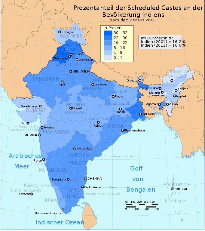
Deutsch: Anteil der Angehörigen gelisteter Kasten (scheduled castes) ander indischen Bevölkerung nach Bundesstaaten und Unionsterritorien und nach dem Zensus von 2011.
English: This demographic map shows Scheduled Castes (SC, Dalit) as a percent of each state and union territory's population per 2011 Census of India. Punjab had the highest percentage Dalit population in 2011 among all Indian states (31.9%), while Nagaland, Arunachal Pradesh, Andaman & Nicobar Islands and Lakshadweep had 0%. |
||
| Date | |||
| Source |
This file was derived from: 2011 Census Scheduled Caste caste distribution map India by state and union territory.svg
|
||
| Author | |||
| Permission (Reusing this file) |
I, the copyright holder of this work, hereby publish it under the following licenses:
This file is licensed under the Creative Commons Attribution-Share Alike 4.0 International license.
You may select the license of your choice. |
||
| Other versions |
|
||
| SVG development | This vector image was created with Adobe Illustrator. |


File history
Click on a date/time to view the file as it appeared at that time.
| Date/Time | Thumbnail | Dimensions | User | Comment | |
|---|---|---|---|---|---|
| current | 21:11, 28 September 2016 | | 825 × 929 (928 KB) | Furfur (talk | contribs) | Farbe des Meeres |
| 12:29, 25 September 2016 |  | 825 × 929 (897 KB) | Furfur (talk | contribs) | Detail | |
| 12:27, 25 September 2016 |  | 825 × 929 (893 KB) | Furfur (talk | contribs) | besser in Blau | |
| 00:09, 24 September 2016 |  | 660 × 746 (1.58 MB) | Furfur (talk | contribs) | Optimierte Version | |
| 07:23, 20 September 2016 |  | 660 × 746 (1.64 MB) | Furfur (talk | contribs) | nochmal | |
| 07:18, 20 September 2016 |  | 660 × 746 (1.64 MB) | Furfur (talk | contribs) | Nachbesserung | |
| 17:58, 18 September 2016 |  | 660 × 746 (1.66 MB) | Furfur (talk | contribs) | Reverted to version as of 11:27, 18 September 2016 (UTC) | |
| 17:56, 18 September 2016 |  | 528 × 597 (1.73 MB) | Furfur (talk | contribs) | ... nochmal | |
| 11:27, 18 September 2016 |  | 660 × 746 (1.66 MB) | Furfur (talk | contribs) | neuer Versuch ... | |
| 11:25, 18 September 2016 |  | 660 × 746 (1.65 MB) | Furfur (talk | contribs) | Bugscape ist eine Zumutung |
You cannot overwrite this file.
File usage on Commons
There are no pages that use this file.
File usage on other wikis
The following other wikis use this file:
- Usage on de.wikipedia.org