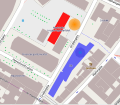
File:2011 Oslo attacks map.svg
来自Wikimedia Commons
跳转到导航
跳转到搜索

此SVG文件的PNG预览的大小:603 × 524像素。 其他分辨率:276 × 240像素 | 552 × 480像素 | 884 × 768像素 | 1,178 × 1,024像素 | 2,357 × 2,048像素。
原始文件 (SVG文件,尺寸为603 × 524像素,文件大小:516 KB)
文件信息
结构化数据
说明
说明
添加一行文字以描述该文件所表现的内容
摘要
[编辑]| 描述2011 Oslo attacks map.svg |
English: Map over the 2011 Oslo attacks.
Deutsch: Karte der Anschläge in Norwegen 2011.
Esperanto: Mapo de la Atakoj en Norvegio (2011).
Español: Mapa de los Ataques en Noruega de 2011.
Français : Carte des Attentats de 2011 en Norvège.
|
| 日期 | (UTC) |
| 来源 | |
| 作者 |
|
| 授权 (二次使用本文件) |
All OpenStreetMap data and maps are Creative Commons "CC-BY-SA 2.0" licensed 本文件采用知识共享署名-相同方式共享 2.0 通用许可协议授权。
|
| 其他版本 |
Derivative works of this file: |
原始上传日志
[编辑]This image is a derivative work of the following images:
- File:2011_Oslo_attacks_-_map1.jpg licensed with Cc-by-sa-3.0, GFDL
- 2011-07-22T19:54:18Z Abbedabb 401x346 (150983 Bytes) {{Information |Description ={{en|1=Map over the [[en:2011 Oslo attacks|2011 Oslo attacks]]. Red building: Government building. Orange area: Position of the remains of the exploaded car. Purple building: Oil Ministry buildi
Uploaded with derivativeFX
文件历史
点击某个日期/时间查看对应时刻的文件。
| 日期/时间 | 缩略图 | 大小 | 用户 | 备注 | |
|---|---|---|---|---|---|
| 当前 | 2011年7月23日 (六) 10:36 |  | 603 × 524(516 KB) | Beao(留言 | 贡献) | Minor positioning. |
| 2011年7月23日 (六) 10:34 |  | 603 × 524(516 KB) | Beao(留言 | 贡献) | {{Information |Description={{en|1=Map over the ''2011 Oslo attacks''. <br>''Red building'': Government building.<br>''Orange area'': Position of the remains of the exploded car.<br>''Blue building'': Oil Ministry building.}} |Source=*[[:File:2011_Oslo_att |
您不可以覆盖此文件。
文件用途
以下4个页面使用本文件:
全域文件用途
以下其他wiki使用此文件:
- be-tarask.wikipedia.org上的用途
- be.wikipedia.org上的用途
- bg.wikipedia.org上的用途
- bs.wikipedia.org上的用途
- ckb.wikipedia.org上的用途
- cs.wikipedia.org上的用途
- da.wikipedia.org上的用途
- eo.wikipedia.org上的用途
- eu.wikipedia.org上的用途
- fa.wikipedia.org上的用途
- fi.wikipedia.org上的用途
- fr.wikipedia.org上的用途
- hr.wikipedia.org上的用途
- hy.wikipedia.org上的用途
- it.wikipedia.org上的用途
- ja.wikipedia.org上的用途
- ko.wikipedia.org上的用途
- la.wikipedia.org上的用途
- mzn.wikipedia.org上的用途
- pl.wikipedia.org上的用途
- pt.wikipedia.org上的用途
- ru.wikipedia.org上的用途
- ru.wikinews.org上的用途
- simple.wikipedia.org上的用途
- sr.wikipedia.org上的用途
- th.wikipedia.org上的用途
- uk.wikipedia.org上的用途
- www.wikidata.org上的用途
- zh.wikipedia.org上的用途
元数据
此文件含有额外信息,这些信息可能是创建或数字化该文件时使用的数码相机或扫描仪所添加的。如果文件已从其原始状态修改,某些详细信息可能无法完全反映修改后的文件。
| 宽度 | 482pt |
|---|---|
| 高度 | 419pt |