File:2011 Syria protests.svg
跳转到导航
跳转到搜索

此SVG文件的PNG预览的大小:725 × 599像素。 其他分辨率:290 × 240像素 | 581 × 480像素 | 929 × 768像素 | 1,239 × 1,024像素 | 2,478 × 2,048像素 | 922 × 762像素。
原始文件 (SVG文件,尺寸为922 × 762像素,文件大小:287 KB)
说明
说明
添加一行文字以描述该文件所表现的内容
W3C-validity not checked.
摘要
[编辑]
| 描述 |
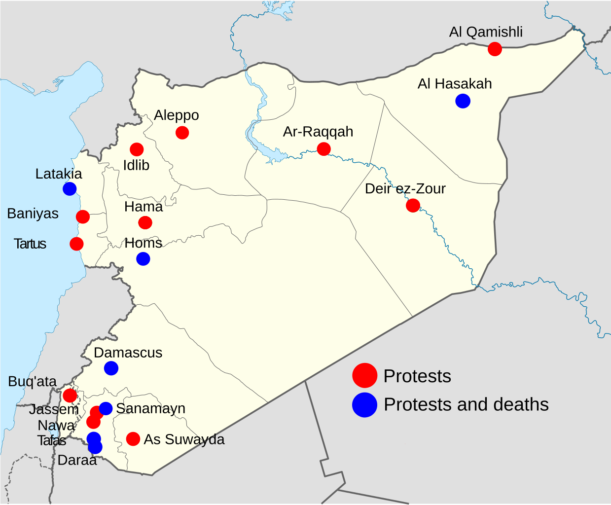
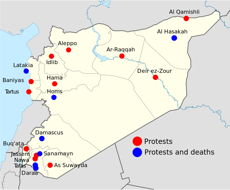
Note: This is an OUTDATED map that stopped being updated since 15 April 2011, protests and deaths has since then occurred in more towns, city's and villages, so this map shouldn't be used at any article. Deutsch: Statuskarte der syrischen Aufstände 2011 English: 2011 Syria protests status map. Français : Carte montrant le status des manifestations en Syrie 2011 Português: Mapa mostrando a situação dos protestos na Síria em 2011 Map is equirectangular projection, N/S stretching 115 %. Geographic limits of the map: * N: 37.6° N * S: 32.0° N * W: 34.9° E * E: 42.7° E |
| 日期 | (UTC) |
| 来源 | |
| 作者 |
|
| 其他版本 |
Derivative works of this file: |
| 这是一张修改过的图片,这意味着它已在原版本的基础上通过软件进行了编辑,改动内容:Made it into a map for 2011 Syrian protests。其原始版本为:Syria location map.svg。修改者:Supreme Deliciousness。
|
我,本作品著作权人,特此采用以下许可协议发表本作品:
本文件采用知识共享署名-相同方式共享 3.0 未本地化版本许可协议授权。
- 您可以自由地:
- 共享 – 复制、发行并传播本作品
- 修改 – 改编作品
- 惟须遵守下列条件:
- 署名 – 您必须对作品进行署名,提供授权条款的链接,并说明是否对原始内容进行了更改。您可以用任何合理的方式来署名,但不得以任何方式表明许可人认可您或您的使用。
- 相同方式共享 – 如果您再混合、转换或者基于本作品进行创作,您必须以与原先许可协议相同或相兼容的许可协议分发您贡献的作品。

|
已授权您依据自由软件基金会发行的无固定段落及封面封底文字(Invariant Sections, Front-Cover Texts, and Back-Cover Texts)的GNU自由文件许可协议1.2版或任意后续版本的条款,复制、传播和/或修改本文件。该协议的副本请见“GNU Free Documentation License”。 |
您可以选择您需要的许可协议。
原始上传日志
[编辑]
This image is a derivative work of the following images:
- File:Syria_location_map.svg licensed with Cc-by-sa-3.0, GFDL
- 2010-09-30T19:34:14Z NordNordWest 922x762 (250221 Bytes) Reverted to version as of 08:25, 29 September 2010: NO CHANGES WITHOUT DISCUSSION
- 2010-09-30T19:08:16Z Supreme Deliciousness 1000x827 (246114 Bytes) All sources on talkpage show with the same color
- 2010-09-29T08:25:21Z NordNordWest 922x762 (250221 Bytes) Reverted to version as of 18:29, 29 November 2008: no changes without discussion
- 2010-09-29T00:36:20Z Supreme Deliciousness 1000x827 (246114 Bytes) Reverted to version as of 18:38, 22 August 2008
- 2008-11-29T18:29:45Z NordNordWest 922x762 (250221 Bytes) '
- 2008-08-22T18:38:21Z NordNordWest 1000x827 (246114 Bytes) {{Information |Description= {{de|Positionskarte von [[:de:Syrien|Syrien]]}} Quadratische Plattkarte, N-S-Streckung 115 %. Geographische Begrenzung der Karte: * N: 37.6° N * S: 32.0° N * W: 34.9° O * O: 42.7° O {{en|Locati
Uploaded with derivativeFX
文件历史
点击某个日期/时间查看对应时刻的文件。
| 日期/时间 | 缩略图 | 大小 | 用户 | 备注 | |
|---|---|---|---|---|---|
| 当前 | 2011年11月12日 (六) 18:55 | | 922 × 762(287 KB) | Fred the Oyster(留言 | 贡献) | Optimise, change font to the more universal Arial |
| 2011年4月15日 (五) 09:48 |  | 922 × 762(424 KB) | Supreme Deliciousness(留言 | 贡献) | 14 April + As Suwayda | |
| 2011年4月9日 (六) 10:12 |  | 922 × 762(422 KB) | Supreme Deliciousness(留言 | 贡献) | April 8, + Tartus, Edlib | |
| 2011年4月2日 (六) 13:19 |  | 922 × 762(420 KB) | Supreme Deliciousness(留言 | 贡献) | Update April 1-2 Damascus death and Buq'ata. Sorry NikNaks93, cant edit your file, have to use mine. | |
| 2011年4月2日 (六) 11:38 |  | 600 × 496(598 KB) | FunkMonk(留言 | 贡献) | My mistake. | |
| 2011年4月2日 (六) 10:29 |  | 600 × 496(598 KB) | NikNaks(留言 | 贡献) | One last try with text as paths | |
| 2011年4月2日 (六) 10:27 |  | 600 × 496(481 KB) | NikNaks(留言 | 贡献) | Try again. | |
| 2011年4月2日 (六) 10:26 |  | 300 × 248(493 KB) | NikNaks(留言 | 贡献) | A little cleanup and normalisation to try to fix the text rendering | |
| 2011年3月26日 (六) 18:50 |  | 922 × 762(419 KB) | Supreme Deliciousness(留言 | 贡献) | Tafas | |
| 2011年3月26日 (六) 00:10 |  | 922 × 762(419 KB) | Supreme Deliciousness(留言 | 贡献) | Update, 25 March, Sanamayn, Homs, Latakia |
您不可以覆盖此文件。
文件用途
以下5个页面使用本文件:
全域文件用途
以下其他wiki使用此文件:
- ca.wikinews.org上的用途
- en.wikipedia.org上的用途
- fi.wikipedia.org上的用途
- hu.wikipedia.org上的用途
- it.wikipedia.org上的用途
- sh.wikipedia.org上的用途
- ta.wikipedia.org上的用途
- zh.wikipedia.org上的用途