File:2012-06 Jeszkotle 02.jpg
Jump to navigation
Jump to search

Size of this preview: 800 × 533 pixels. Other resolutions: 320 × 213 pixels | 640 × 427 pixels | 1,024 × 683 pixels | 1,280 × 853 pixels | 2,560 × 1,706 pixels | 3,671 × 2,447 pixels.
Original file (3,671 × 2,447 pixels, file size: 5.16 MB, MIME type: image/jpeg)
Captions
Captions
Add a one-line explanation of what this file represents
Summary
[edit]
| Description |
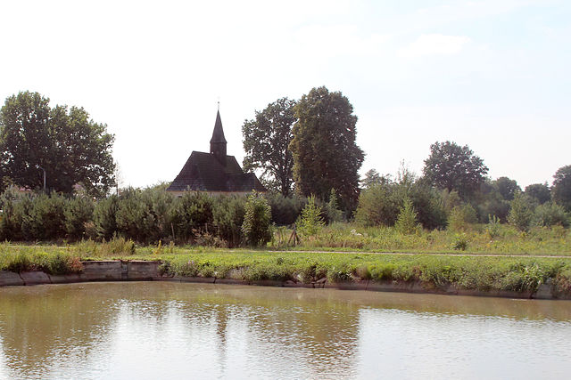
Polski: Jeszkotle -wieś w Polsce w województwie opolskim, w powiecie brzeskim w gminie Grodków.
Deutsch: Jeszkotle (Jäschkittel) ist ein Dorf in Polen in der Wojewodschaft Opole, Gemeinde Grodków.
|
| Date | |
| Source | Own work |
| Author | Ralf Lotys (Sicherlich) |
| Permission (Reusing this file) |
This file is licensed under the Creative Commons Attribution 4.0 International license. Attribution: Ralf Lotys (Sicherlich)
|
| Camera location | | View this and other nearby images on: OpenStreetMap |
|---|
File history
Click on a date/time to view the file as it appeared at that time.
| Date/Time | Thumbnail | Dimensions | User | Comment | |
|---|---|---|---|---|---|
| current | 16:43, 28 February 2015 | | 3,671 × 2,447 (5.16 MB) | Sicherlich (talk | contribs) |
You cannot overwrite this file.
File usage on Commons
The following page uses this file:
File usage on other wikis
The following other wikis use this file:
- Usage on de.wikipedia.org
Metadata
This file contains additional information such as Exif metadata which may have been added by the digital camera, scanner, or software program used to create or digitize it. If the file has been modified from its original state, some details such as the timestamp may not fully reflect those of the original file. The timestamp is only as accurate as the clock in the camera, and it may be completely wrong.
| Camera manufacturer | Canon |
|---|---|
| Camera model | Canon EOS 600D |
| Author | Ralf Lotys |
| Copyright holder | |
| Exposure time | 1/160 sec (0.00625) |
| F-number | f/11 |
| ISO speed rating | 100 |
| Date and time of data generation | 14:46, 4 August 2012 |
| Lens focal length | 31 mm |
| Latitude | 50° 42′ 42.26″ N |
| Longitude | 17° 14′ 33.62″ E |
| Altitude | 189.679 meters above sea level |
| Label | kościół fil. pw. św. Antoniego Padewskieg |
| Online copyright statement | https://creativecommons.org/licenses/by/4.0/deed.en |
| Image title |
|
| Short title | |
| Usage terms | |
| City shown | Jeszkotle |
| Horizontal resolution | 6,170 dpi |
| Vertical resolution | 6,170 dpi |
| Software used | Adobe Photoshop Lightroom 3.6 (Macintosh) |
| File change date and time | 17:04, 28 February 2015 |
| Exposure Program | Landscape mode (for landscape photos with the background in focus) |
| Exif version | 2.3 |
| Date and time of digitizing | 14:46, 4 August 2012 |
| APEX shutter speed | 7.321928 |
| APEX aperture | 6.918863 |
| APEX exposure bias | 0 |
| Maximum land aperture | 4.375 APEX (f/4.56) |
| Metering mode | Pattern |
| Flash | Flash did not fire, compulsory flash suppression |
| DateTimeOriginal subseconds | 37 |
| DateTimeDigitized subseconds | 37 |
| Focal plane X resolution | 5,728.1767955801 |
| Focal plane Y resolution | 5,808.4033613445 |
| Focal plane resolution unit | inches |
| Custom image processing | Normal process |
| Exposure mode | Auto exposure |
| White balance | Auto white balance |
| Scene capture type | Standard |
| GPS time (atomic clock) | 13:52 |
| Geodetic survey data used | WGS-84 |
| GPS date | 18 August 2012 |
| GPS tag version | 0.0.2.2 |
| Serial number of camera | 083063015325 |
| Lens used | EF-S18-55mm f/3.5-5.6 |
| Date metadata was last modified | 18:04, 28 February 2015 |
| Unique ID of original document | 1DFC520B0E99E03A2325385C1CC4847C |
| Copyright status | Copyrighted |
| Keywords |
|
| Country shown | Poland |
| Province or state shown | Województwo Dolnośląskie |
| Code for country shown | PL |
| IIM version | 4 |