File:2014 Russo-ukrainian-conflict map.svg
跳转到导航
跳转到搜索

此SVG文件的PNG预览的大小:552 × 599像素。 其他分辨率:221 × 240像素 | 442 × 480像素 | 707 × 768像素 | 943 × 1,024像素 | 1,886 × 2,048像素 | 4,126 × 4,480像素。
原始文件 (SVG文件,尺寸为4,126 × 4,480像素,文件大小:2.75 MB)
说明
说明
添加一行文字以描述该文件所表现的内容
摘要[编辑]
| 描述 |
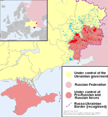
English: Map of the '2014 Russo-Ukrainian War', '2014 Russian invasion of Ukraine' or '2014 Russian military intervention in Ukraine'.
(Includes '2014 Crimean Crisis' and 'War in Donbass') |
| 日期 | |
| 来源 | 自己的作品 |
| 作者 | Niele |
| 其他版本 |
[]
|
| SVG开发 |


.png)


许可协议[编辑]
我,本作品著作权人,特此采用以下许可协议发表本作品:
本文件采用知识共享署名-相同方式共享 4.0 国际许可协议授权。
- 您可以自由地:
- 共享 – 复制、发行并传播本作品
- 修改 – 改编作品
- 惟须遵守下列条件:
- 署名 – 您必须对作品进行署名,提供授权条款的链接,并说明是否对原始内容进行了更改。您可以用任何合理的方式来署名,但不得以任何方式表明许可人认可您或您的使用。
- 相同方式共享 – 如果您再混合、转换或者基于本作品进行创作,您必须以与原先许可协议相同或相兼容的许可协议分发您贡献的作品。
文件历史
点击某个日期/时间查看对应时刻的文件。
| 日期/时间 | 缩略图 | 大小 | 用户 | 备注 | |
|---|---|---|---|---|---|
| 当前 | 2014年10月9日 (四) 16:03 | | 4,126 × 4,480(2.75 MB) | Mondolkiri1(留言 | 贡献) | Marinka and Novotroitske - http://militarymaps.info/ |
| 2014年10月9日 (四) 03:27 |  | 4,126 × 4,480(2.75 MB) | Mondolkiri1(留言 | 贡献) | Update according to http://militarymaps.info/ and other sources provided in File:East Ukraine Conflict.svg | |
| 2014年10月6日 (一) 23:30 |  | 4,126 × 4,480(2.74 MB) | Mondolkiri1(留言 | 贡献) | Corrected Zolote and added Novoslapa | |
| 2014年10月6日 (一) 23:20 |  | 4,126 × 4,480(2.74 MB) | Mondolkiri1(留言 | 贡献) | Update according to http://militarymaps.info/ , http://www.segodnya.ua/regions/donetsk/moskal-boeviki-obyavili-na-menya-ohotu-558223.html and other sources in my talk page | |
| 2014年10月5日 (日) 07:13 |  | 4,126 × 4,480(2.74 MB) | Mondolkiri1(留言 | 贡献) | Update Donbass according to File:East Ukraine Conflict.svg | |
| 2014年9月19日 (五) 17:50 |  | 4,126 × 4,480(2.73 MB) | Hanibal911(留言 | 贡献) | POV Vandalism I revert all unjustified changes which was made based unreliable sources | |
| 2014年9月19日 (五) 07:46 |  | 4,126 × 4,480(2.71 MB) | Niele~commonswiki(留言 | 贡献) | - Added Lutuhyne tot the red area as suggested by user Mondolkiri1 - Updated legenda and unclear/conflicting report-colours. This was a constructive way to prevent discussions, edit warring on basis of conflicting sources | |
| 2014年9月18日 (四) 13:26 |  | 4,126 × 4,480(2.73 MB) | Hanibal911(留言 | 贡献) | POV Pushing we not use this not correct maps which contradicts to many sources | |
| 2014年9月18日 (四) 13:01 |  | 4,126 × 4,480(2.7 MB) | Niele~commonswiki(留言 | 贡献) | Not true, http://mediarnbo.org/ is the official communication-website of Ukrainean Forces, while http://liveuamap.com is unofficial map hosted from the us.Reverted to version as of 12:40, 18 September 2014 | |
| 2014年9月18日 (四) 12:44 |  | 4,126 × 4,480(2.73 MB) | Mondolkiri1(留言 | 贡献) | Reverted to version as of 12:32, 18 September 2014 Sorry, but the http://liveuamap.com/ is the official Ukrainian ATO site, and as I said, Lutuhyne is in the pink area there, not in the foggy zone! |
您不可以覆盖此文件。
文件用途
以下页面使用本文件:
全域文件用途
以下其他wiki使用此文件:
- af.wikipedia.org上的用途
- bn.wikipedia.org上的用途
- cs.wikipedia.org上的用途
- de.wikipedia.org上的用途
- en.wikipedia.org上的用途
- fi.wikipedia.org上的用途
- he.wikipedia.org上的用途
- incubator.wikimedia.org上的用途
- it.wikiquote.org上的用途
- ja.wikipedia.org上的用途
- ka.wikipedia.org上的用途
- lv.wikipedia.org上的用途
- mk.wikipedia.org上的用途
- ne.wikipedia.org上的用途
- nl.wikipedia.org上的用途
- pt.wikipedia.org上的用途
- ru.wikinews.org上的用途
- ru.wikiquote.org上的用途
- sd.wikipedia.org上的用途
- te.wikipedia.org上的用途
- uk.wikipedia.org上的用途
- uk.wikiquote.org上的用途
- vi.wikipedia.org上的用途
元数据
分类: