File:2016 Oregon Ballot Measure 100 results map by county.svg
Jump to navigation
Jump to search

Size of this PNG preview of this SVG file: 744 × 565 pixels. Other resolutions: 316 × 240 pixels | 632 × 480 pixels | 1,011 × 768 pixels | 1,280 × 972 pixels | 2,560 × 1,944 pixels.
Original file (SVG file, nominally 744 × 565 pixels, file size: 237 KB)
Captions
Captions
Add a one-line explanation of what this file represents
| Description |
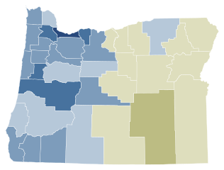
English: Results by county of Oregon Ballot Measure 100 (2016). Green indicates a "yes" vote, and red indicates a "no" vote.
Support 90%–100% 80%–90% 70%–80% 60%–70% 50%–60%
Tie Exact tie
Oppose 50%–60% 60%–70% 70%–80% 80%–90% 90%–100% |
||
| Date | |||
| Source | Own work | ||
| Author | Kingofthedead | ||
| Permission (Reusing this file) |
|

File history
Click on a date/time to view the file as it appeared at that time.
| Date/Time | Thumbnail | Dimensions | User | Comment | |
|---|---|---|---|---|---|
| current | 20:54, 29 June 2022 | | 744 × 565 (237 KB) | WikiBunny2K1 (talk | contribs) | Colorblind-friendly shape |
| 05:00, 20 January 2019 |  | 248 × 188 (34 KB) | Kingofthedead (talk | contribs) | shade | |
| 05:29, 12 November 2016 |  | 806 × 601 (105 KB) | Kingofthedead (talk | contribs) | {{Information |Description = {{en|1=Results by county of Oregon Ballot Measure 100 (2016). Green indicates a "yes" vote, and red indicates a "no" vote.}} |Source = {{own}} |Author = [[User:MB298... |
You cannot overwrite this file.
File usage on Commons
The following 4 pages use this file:
File usage on other wikis
The following other wikis use this file:
- Usage on en.wikipedia.org