File:2017 UK local elections - Ward and Council Control.svg
Jump to navigation
Jump to search

Size of this PNG preview of this SVG file: 706 × 599 pixels. Other resolutions: 283 × 240 pixels | 565 × 480 pixels | 905 × 768 pixels | 1,206 × 1,024 pixels | 2,412 × 2,048 pixels | 967 × 821 pixels.
Original file (SVG file, nominally 967 × 821 pixels, file size: 13.23 MB)
Captions
Captions
Add a one-line explanation of what this file represents
Summary[edit]
| Description |
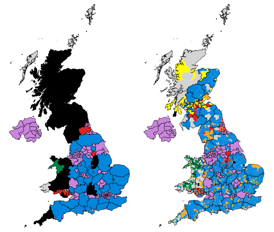
English: Map of the results of the 2017 UK local elections, showing party control by council (left), and the most popular party by ward (right). |
| Date | |
| Source | Own work. Map made utilising data from the Ordnance Survey & Local Government Boundary Commission in Scotland. Council control based on information from the BBC - Scotland, England, Wales. Ward results are from individual councils. |
| Author | MrPenguin20 |
Licensing[edit]
I, the copyright holder of this work, hereby publish it under the following license:
This file is licensed under the Creative Commons Attribution-Share Alike 4.0 International license.
- You are free:
- to share – to copy, distribute and transmit the work
- to remix – to adapt the work
- Under the following conditions:
- attribution – You must give appropriate credit, provide a link to the license, and indicate if changes were made. You may do so in any reasonable manner, but not in any way that suggests the licensor endorses you or your use.
- share alike – If you remix, transform, or build upon the material, you must distribute your contributions under the same or compatible license as the original.
This file is licensed by the Ordnance Survey of the United Kingdom under their OS OpenData License
In short: you are free to distribute and modify the file as long as you attribute (including year), the Ordnance Survey. Attribution: Contains Ordnance Survey data © Crown copyright and database right (year) Note: Derivative works can be licensed under any Creative Commons Attribution 3.0 Licence. |
.svg)
|
This file is licensed under the United Kingdom Open Government Licence v3.0. |
See also: Meta for information on usage on Wikimedia wikis.
|
File history
Click on a date/time to view the file as it appeared at that time.
| Date/Time | Thumbnail | Dimensions | User | Comment | |
|---|---|---|---|---|---|
| current | 22:23, 29 January 2018 | | 967 × 821 (13.23 MB) | MrPenguin20 (talk | contribs) | Completed last several councils. |
| 18:17, 10 November 2017 |  | 967 × 821 (13.22 MB) | Into oblivion (talk | contribs) | Added 'West Sussex' and 'Wiltshire' areas | |
| 22:10, 9 May 2017 |  | 967 × 821 (13.22 MB) | Renamed user OCfxJKu7j2 (talk | contribs) | Scottish results | |
| 18:36, 9 May 2017 |  | 967 × 821 (13.22 MB) | MrPenguin20 (talk | contribs) | Updated Wales. | |
| 10:16, 7 May 2017 |  | 967 × 821 (13.21 MB) | MrPenguin20 (talk | contribs) | Durham - although will have to double check voter figures for some wards with split representation. | |
| 02:09, 7 May 2017 |  | 967 × 821 (13.21 MB) | Into oblivion (talk | contribs) | Added 'East Sussex' and 'Cardiff' areas | |
| 20:21, 6 May 2017 |  | 967 × 821 (13.19 MB) | MrPenguin20 (talk | contribs) | More results. | |
| 18:30, 6 May 2017 |  | 967 × 821 (13.18 MB) | MrPenguin20 (talk | contribs) | More results. | |
| 23:33, 5 May 2017 |  | 967 × 821 (13.18 MB) | MrPenguin20 (talk | contribs) | More ward results. | |
| 23:06, 5 May 2017 |  | 967 × 821 (13.17 MB) | MrPenguin20 (talk | contribs) | Updates. |
You cannot overwrite this file.
File usage on Commons
There are no pages that use this file.
File usage on other wikis
The following other wikis use this file:
- Usage on cy.wikipedia.org
- Usage on en.wikipedia.org
- Usage on fr.wikipedia.org
- Usage on zh.wikipedia.org