File:2017 ischia earthquake shakemap.jpg
Jump to navigation
Jump to search

Size of this preview: 491 × 600 pixels. Other resolutions: 196 × 240 pixels | 393 × 480 pixels | 629 × 768 pixels | 838 × 1,024 pixels | 2,048 × 2,502 pixels.
Original file (2,048 × 2,502 pixels, file size: 447 KB, MIME type: image/jpeg)
Captions
Captions
Add a one-line explanation of what this file represents
Summary
[edit]
| Description |
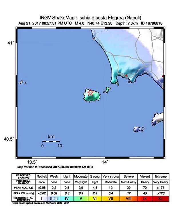
English: Shake map of the Ischia Mw 4.0 earthquake of 2017-08-21 18:57:51 UTC
Italiano: Mappa di scuotimento del terremoto Mw 4.0 che ha colpito l'isola di Ischia il 2017-08-21 18:57:51 UTC |
| Date | |
| Source | https://ingvterremoti.wordpress.com/2017/09/14/il-terremoto-di-casamicciola-del-21-agosto-2017-osservazioni-sul-moto-del-suolo/ |
| Author | Istituto Nazionale di Geofisica e Vulcanologia |
Licensing
[edit]
This file is licensed under the Creative Commons Attribution 4.0 International license.
- You are free:
- to share – to copy, distribute and transmit the work
- to remix – to adapt the work
- Under the following conditions:
- attribution – You must give appropriate credit, provide a link to the license, and indicate if changes were made. You may do so in any reasonable manner, but not in any way that suggests the licensor endorses you or your use.
File history
Click on a date/time to view the file as it appeared at that time.
| Date/Time | Thumbnail | Dimensions | User | Comment | |
|---|---|---|---|---|---|
| current | 16:57, 18 April 2019 | | 2,048 × 2,502 (447 KB) | Lrt000 (talk | contribs) | {{Information |description ={{en|1=Shake map of the Ischia Mw 4.0 earthquake of 2017-08-21 18:57:51 UTC}} {{it|1=Mappa di scuotimento del terremoto Mw 4.0 che ha colpito l'isola di Ischia il 2017-08-21 18:57:51 UTC}} |date =2019-04-18 |source =https://ingvterremoti.wordpress.com/2017/09/14/il-terremoto-di-casamicciola-del-21-agosto-2017-osservazioni-sul-moto-del-suolo/ |author =Istituto Nazionale di Geofisica e Vulcanologia }} |
You cannot overwrite this file.
File usage on Commons
There are no pages that use this file.
File usage on other wikis
The following other wikis use this file:
- Usage on it.wikipedia.org