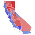
File:2022 United States Senate election in California results map by county.svg
出自Wikimedia Commons
跳至導覽
跳至搜尋

此 SVG 檔案的 PNG 預覽的大小:600 × 600 像素。 其他解析度:240 × 240 像素 | 480 × 480 像素 | 768 × 768 像素 | 1,024 × 1,024 像素 | 2,048 × 2,048 像素 | 810 × 810 像素。
原始檔案 (SVG 檔案,表面大小:810 × 810 像素,檔案大小:63 KB)
檔案資訊
結構化資料
說明
說明
添加單行說明來描述出檔案所代表的內容
摘要
[編輯]| 描述2022 United States Senate election in California results map by county.svg |
English: Results of the 2022 United States Senate election in California by county. |
| 日期 | |
| 來源 | 自己的作品 |
| 作者 | Elli |
| This file has been created using a standardized map of a state's counties: California county map, cb 500k.svg. A full list of available maps exists at Category:Standardized SVG county maps of US states. |
 |
授權條款
[編輯]我,本作品的著作權持有者,決定用以下授權條款發佈本作品:
| 此檔案在創用CC CC0 1.0 通用公有領域貢獻宣告之下分發。 | |
| 在此宣告之下分發本作品者,已依據各國著作權法,在全世界放棄其對本作品所擁有的著作權及所有相關相似的法律權利,從而將本作品貢獻至公有領域。您可以複製、修改、分發和演示該作品,用於任何商業用途,所有這些都不需要請求授權。
http://creativecommons.org/publicdomain/zero/1.0/deed.enCC0Creative Commons Zero, Public Domain Dedicationfalsefalse |
檔案歷史
點選日期/時間以檢視該時間的檔案版本。
| 日期/時間 | 縮圖 | 尺寸 | 用戶 | 備註 | |
|---|---|---|---|---|---|
| 目前 | 2024年1月24日 (三) 07:45 |  | 810 × 810(63 KB) | Putitonamap98(對話 | 貢獻) | shapes |
| 2023年6月5日 (一) 23:16 |  | 744 × 744(596 KB) | Wei-On Yeo(對話 | 貢獻) | Reverted to version as of 23:35, 9 May 2023 (UTC). Sacramento County is just below 60%, still meaning it's in the 50-60% range. | |
| 2023年6月1日 (四) 01:11 |  | 744 × 744(596 KB) | Kart2401real(對話 | 貢獻) | Fixed Saacramento | |
| 2023年5月9日 (二) 23:35 |  | 744 × 744(596 KB) | Wei-On Yeo(對話 | 貢獻) | Fixed ocean border for Santa Barabra County | |
| 2023年5月9日 (二) 23:05 |  | 744 × 744(611 KB) | Wei-On Yeo(對話 | 貢獻) | updated final | |
| 2022年11月23日 (三) 11:42 |  | 744 × 744(595 KB) | Elli(對話 | 貢獻) | Uploaded own work with UploadWizard |
無法覆蓋此檔案。
檔案用途
下列4個頁面有用到此檔案:
全域檔案使用狀況
以下其他 wiki 使用了這個檔案:
- de.wikipedia.org 的使用狀況
- en.wikipedia.org 的使用狀況
- ja.wikipedia.org 的使用狀況
- ru.wikipedia.org 的使用狀況
- zh.wikipedia.org 的使用狀況
詮釋資料
此檔案中包含其他資訊,這些資訊可能是由數位相機或掃描器在建立或數位化過程中所新增的。若檔案自原始狀態已被修改,一些詳細資料可能無法完整反映出已修改的檔案。
| 寬度 | 810 |
|---|---|
| 高度 | 810 |