File:2023 CWB 蘇拉 forecast map (zh-TW).png
Jump to navigation
Jump to search

Size of this preview: 800 × 586 pixels. Other resolutions: 320 × 234 pixels | 640 × 469 pixels | 956 × 700 pixels.
Original file (956 × 700 pixels, file size: 76 KB, MIME type: image/png)
Captions
Captions
Add a one-line explanation of what this file represents
Summary
[edit]| Description |
|
| Date | |
| Source | https://www.cwb.gov.tw/Data/typhoon/TY_NEWS/Download_PTA_202309021800_TD10_zhtw.png |
| Author | Central Weather Administration |
| Other versions |
English: .png) |

.png&action=edit§ion=1)
Licensing
[edit].png&action=edit§ion=2)

|
The copyright holder of this file, Central Weather Administration, allows anyone to use it for any purpose, provided that the copyright holder is properly attributed. Redistribution, derivative work, commercial use, and all other use is permitted. |
Attribution:
|
|
|
This file is licensed under the Government Website Open Information Announcement.
Information on Related Items:
|
 |
|
|
File history
Click on a date/time to view the file as it appeared at that time.
.png&dir=prev)
.png&offset=20230901020804)
.png&offset=&limit=20)
.png&offset=&limit=50)
.png&offset=&limit=100)
.png&offset=&limit=250)
.png&offset=&limit=500)
| Date/Time | Thumbnail | Dimensions | User | Comment | |
|---|---|---|---|---|---|
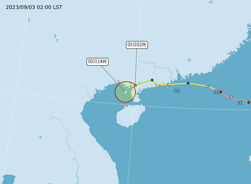
| current | 19:32, 2 September 2023 | | 956 × 700 (76 KB) | Cewbot (talk | contribs) | Import CWB tropical cyclone forecast map of Northwest Pacific 熱帶性低氣壓蘇拉: 3日2時的中心位置在北緯 21.6 度,東經 110.0 度,以每小時9公里速度,向西南西進行。中心氣壓1000百帕,近中心最大風速每秒15公尺,瞬間最大陣風每秒 23 公尺。 https://www.cwb.gov.tw/Data/typhoon/TY_NEWS/Download_PTA_202309021800_TD10_zhtw.png (2023-09-02 18:00 UTC) |
| 13:32, 2 September 2023 |  | 956 × 700 (91 KB) | Cewbot (talk | contribs) | Import CWB tropical cyclone forecast map of Northwest Pacific 輕度颱風蘇拉: 2日20時的中心位置在北緯 22.1 度,東經 111.4 度,以每小時13公里速度,向西南西進行。中心氣壓995百帕,近中心最大風速每秒20公尺,瞬間最大陣風每秒 28 公尺,七級風平均暴風半徑 80 公里(西北側 80 公里、東北側 80 公里、西南側 80 公里、東南側 80 公里),十級風平均暴風半徑 - 公里。 https://www.cwb.gov.tw/Data/typhoon/TY_NEWS/Download_PTA_202309021200_SAOLA_zhtw.png (2023-09-02 12:00 UTC) | |
| 08:07, 2 September 2023 |  | 956 × 700 (101 KB) | Cewbot (talk | contribs) | Import CWB tropical cyclone forecast map of Northwest Pacific 輕度颱風蘇拉: 2日14時的中心位置在北緯 21.8 度,東經 111.8 度,以每小時13公里速度,向西南西進行。中心氣壓975百帕,近中心最大風速每秒30公尺,瞬間最大陣風每秒 38 公尺,七級風平均暴風半徑 100 公里(西北側 70 公里、東北側 120 公里、西南側 100 公里、東南側 120 公里),十級風平均暴風半徑 50 公里(西北側 50 公里、東北側 50 公里、西南側 50 公里、東南側 50 公里)。 https://www.cwb.gov.tw/Data/typhoon/TY_NEWS/Download_PTA_202309020600_SAOLA_zhtw.png (2023-09-02 06:00 UTC) | |
| 01:32, 2 September 2023 |  | 956 × 700 (109 KB) | Cewbot (talk | contribs) | Import CWB tropical cyclone forecast map of Northwest Pacific 中度颱風蘇拉: 2日8時的中心位置在北緯 21.8 度,東經 112.8 度,以每小時14公里速度,向西南西進行。中心氣壓970百帕,近中心最大風速每秒33公尺,瞬間最大陣風每秒 43 公尺,七級風平均暴風半徑 150 公里(西北側 120 公里、東北側 170 公里、西南側 150 公里、東南側 170 公里),十級風平均暴風半徑 50 公里(西北側 50 公里、東北側 50 公里、西南側 50 公里、東南側 50 公里)。 https://www.cwb.gov.tw/Data/typhoon/TY_NEWS/Download_PTA_202309020000_SAOLA_zhtw.png (2023-09-02 00:00 UTC) | |
| 20:07, 1 September 2023 |  | 956 × 700 (110 KB) | Cewbot (talk | contribs) | Import CWB tropical cyclone forecast map of Northwest Pacific 中度颱風蘇拉: 2日2時的中心位置在北緯 21.9 度,東經 113.5 度,以每小時13公里速度,向西南西進行。中心氣壓965百帕,近中心最大風速每秒35公尺,瞬間最大陣風每秒 45 公尺,七級風平均暴風半徑 150 公里(西北側 120 公里、東北側 170 公里、西南側 150 公里、東南側 170 公里),十級風平均暴風半徑 50 公里(西北側 50 公里、東北側 50 公里、西南側 50 公里、東南側 50 公里)。 https://www.cwb.gov.tw/Data/typhoon/TY_NEWS/Download_PTA_202309011800_SAOLA_zhtw.png (2023-09-01 18:00 UTC) | |
| 14:32, 1 September 2023 |  | 956 × 700 (118 KB) | Cewbot (talk | contribs) | Import CWB tropical cyclone forecast map of Northwest Pacific 中度颱風蘇拉: 1日20時的中心位置在北緯 22.0 度,東經 114.5 度,以每小時13公里速度,向西南西進行。中心氣壓945百帕,近中心最大風速每秒43公尺,瞬間最大陣風每秒 53 公尺,七級風平均暴風半徑 150 公里(西北側 120 公里、東北側 150 公里、西南側 170 公里、東南側 140 公里),十級風平均暴風半徑 50 公里(西北側 40 公里、東北側 50 公里、西南側 60 公里、東南側 50 公里)。 https://www.cwb.gov.tw/Data/typhoon/TY_NEWS/Download_PTA_202309011200_SAOLA_zhtw.png (2023-09-01 12:00 UTC) | |
| 14:07, 1 September 2023 |  | 956 × 700 (115 KB) | Cewbot (talk | contribs) | Import CWB tropical cyclone forecast map of Northwest Pacific 中度颱風蘇拉: 1日20時的中心位置在北緯 22.0 度,東經 114.5 度,以每小時13公里速度,向西南西進行。中心氣壓940百帕,近中心最大風速每秒45公尺,瞬間最大陣風每秒 55 公尺,七級風平均暴風半徑 150 公里(西北側 120 公里、東北側 150 公里、西南側 170 公里、東南側 140 公里),十級風平均暴風半徑 50 公里(西北側 40 公里、東北側 50 公里、西南側 60 公里、東南側 50 公里)。 https://www.cwb.gov.tw/Data/typhoon/TY_NEWS/Download_PTA_202309011200_SAOLA_zhtw.png (2023-09-01 12:00 UTC) | |
| 08:07, 1 September 2023 |  | 956 × 700 (123 KB) | Cewbot (talk | contribs) | Import CWB tropical cyclone forecast map of Northwest Pacific 中度颱風蘇拉: 1日14時的中心位置在北緯 21.9 度,東經 115.5 度,以每小時12公里速度,向西進行。中心氣壓940百帕,近中心最大風速每秒45公尺,瞬間最大陣風每秒 55 公尺,七級風平均暴風半徑 150 公里(西北側 160 公里、東北側 160 公里、西南側 150 公里、東南側 130 公里),十級風平均暴風半徑 50 公里(西北側 50 公里、東北側 50 公里、西南側 50 公里、東南側 40 公里)。 https://www.cwb.gov.tw/Data/typhoon/TY_NEWS/Download_PTA_202309010600_SAOLA_zhtw.png (2023-09-01 06:00 UTC) | |
| 07:33, 1 September 2023 |  | 956 × 700 (123 KB) | Cewbot (talk | contribs) | Import CWB tropical cyclone forecast map of Northwest Pacific 中度颱風蘇拉: 1日14時的中心位置在北緯 21.9 度,東經 115.5 度,以每小時12公里速度,向西進行。中心氣壓940百帕,近中心最大風速每秒45公尺,瞬間最大陣風每秒 55 公尺,七級風平均暴風半徑 150 公里(西北側 160 公里、東北側 160 公里、西南側 150 公里、東南側 130 公里),十級風平均暴風半徑 50 公里(西北側 50 公里、東北側 50 公里、西南側 50 公里、東南側 40 公里)。 https://www.cwb.gov.tw/Data/typhoon/TY_NEWS/Download_PTA_202309010600_SAOLA_zhtw.png (2023-09-01 06:00 UTC) | |
| 02:08, 1 September 2023 |  | 956 × 700 (115 KB) | Cewbot (talk | contribs) | Import CWB tropical cyclone forecast map of Northwest Pacific 中度颱風蘇拉: 1日8時的中心位置在北緯 21.8 度,東經 116.2 度,以每小時13公里速度,向西北西進行。中心氣壓930百帕,近中心最大風速每秒48公尺,瞬間最大陣風每秒 58 公尺,七級風平均暴風半徑 150 公里(西北側 150 公里、東北側 210 公里、西南側 120 公里、東南側 120 公里),十級風平均暴風半徑 70 公里(西北側 70 公里、東北側 70 公里、西南側 70 公里、東南側 70 公里)。 https://www.cwb.gov.tw/Data/typhoon/TY_NEWS/Download_PTA_202309010000_SAOLA_zhtw.png (2023-09-01 00:00 UTC) |
You cannot overwrite this file.
File usage on Commons
The following page uses this file:
File usage on other wikis
The following other wikis use this file:
- Usage on pt.wikinews.org
- Usage on www.wikidata.org
.png&oldid=797895318)