File:669px DEMBauges titrage.png
Jump to navigation
Jump to search
No higher resolution available.
669px_DEMBauges_titrage.png (631 × 571 pixels, file size: 675 KB, MIME type: image/png)
Captions
Captions
Add a one-line explanation of what this file represents
Summary
[edit]
| Description |
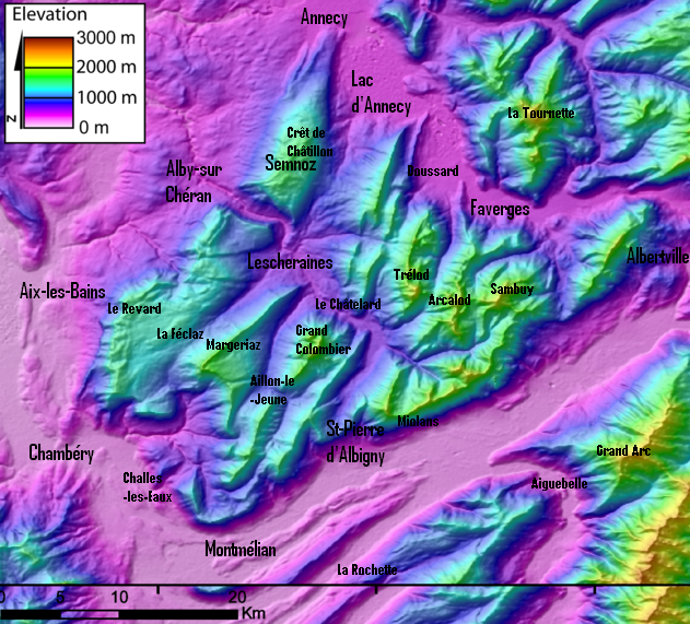
Français : DEM of the Bauges massifs (french Alps) created by Jide from the 90m pixel size SRTM dataset. The massif is located between the Bourget Lake (to the West) and the Annecy Lake (to the NE). The ENE-WSW valley to the South is the Isere valley downstrem to the West). The Cheran river cut the massif from the SE to the NW.
Modifié par Semnoz pour mettre les titres. -Semnoz 25 février 2006 à 19:34 (CET) |
| Date | 25 February 2006 (original upload date) |
| Source | Transferred from fr.wikipedia to Commons. |
| Author | Semnoz at French Wikipedia |
Licensing
[edit]
| This work has been released into the public domain by its author, Semnoz at French Wikipedia. This applies worldwide. In some countries this may not be legally possible; if so: Semnoz grants anyone the right to use this work for any purpose, without any conditions, unless such conditions are required by law. |
Original upload log
[edit]
The original description page was here. All following user names refer to fr.wikipedia.
- 2006-02-25 18:34 Semnoz 669×599× (1003038 bytes) == Summary == DEM of the Bauges massifs (french Alps) created by Jide from the 90m pixel size SRTM dataset. The massif is located between the Bourget Lake (to the West) and the Annecy Lake (to the NE). The ENE-WSW valley to the South is the Isere valley d
File history
Click on a date/time to view the file as it appeared at that time.
| Date/Time | Thumbnail | Dimensions | User | Comment | |
|---|---|---|---|---|---|
| current | 20:57, 17 February 2024 | | 631 × 571 (675 KB) | Rémih (talk | contribs) | Cropped 6 % horizontally, 5 % vertically using CropTool with precise mode. |
| 20:00, 20 September 2009 |  | 669 × 599 (980 KB) | Francofranco56 (talk | contribs) | {{Information |Description={{fr|DEM of the Bauges massifs (french Alps) created by Jide from the 90m pixel size SRTM dataset. The massif is located between the Bourget Lake (to the West) and the Annecy Lake (to the NE). The ENE-WSW valley to the South is |
You cannot overwrite this file.
File usage on Commons
There are no pages that use this file.