File:6I8A8337-HDR-Edit (36780705736).jpg

Original file (5,519 × 3,679 pixels, file size: 16.53 MB, MIME type: image/jpeg)
Captions
Captions
Summary
[edit].jpg&action=edit§ion=1)
| Description |
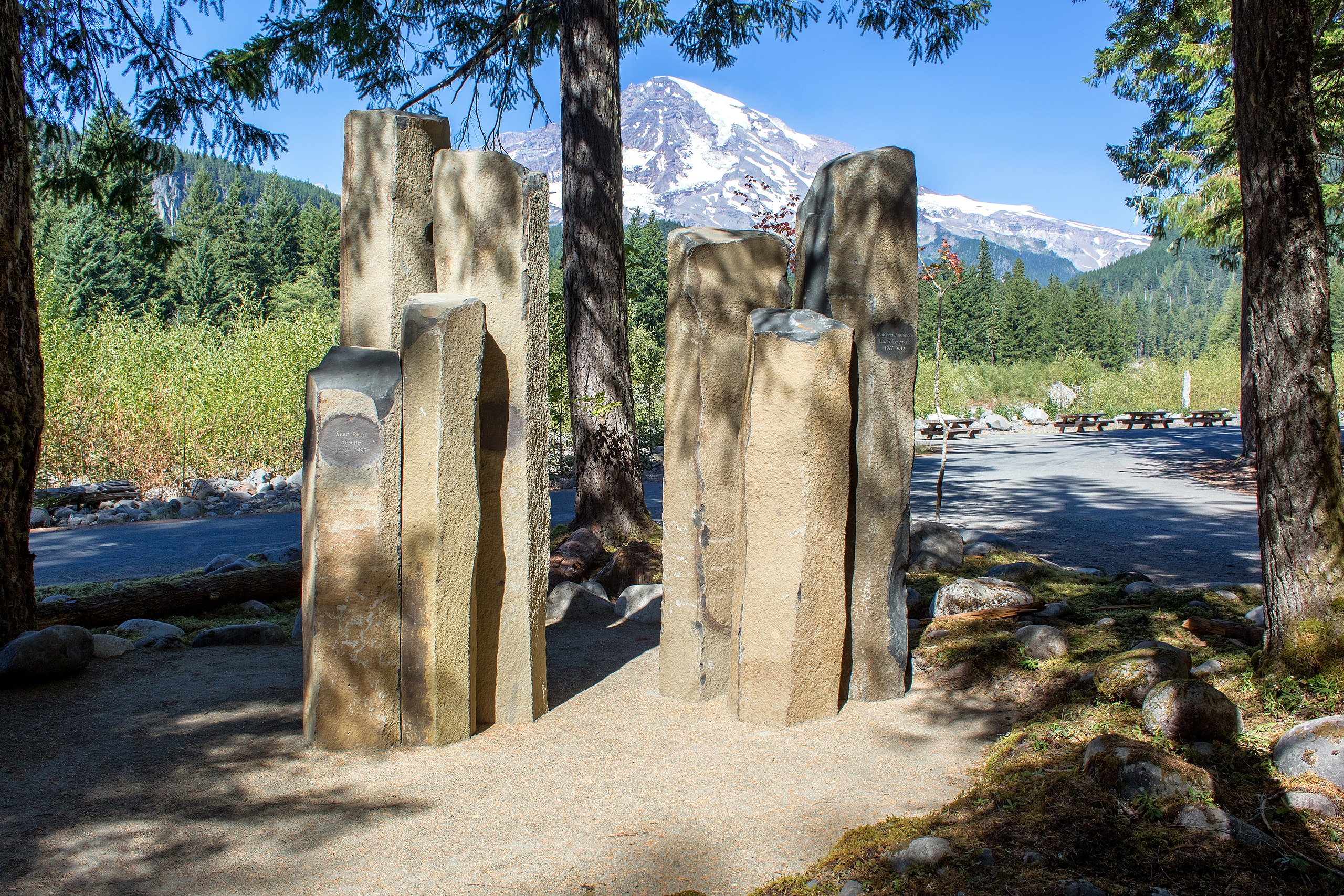
A new memorial was dedicated at Mount Rainier National Park on Friday, August 25, 2017- the 101st anniversary of the National Park Service. The memorial honors four people who lost their lives in the park while in the act of saving or rescuing others. United States Congressman Dave Reichert, Superintendent Randy King and Deputy Superintendent Tracy Swartout spoke at the ceremony. More than 150 friends, family, and park staff attended a dedication ceremony for the Mount Rainier National Park Valor Memorial on Friday, August 25. The memorial was constructed adjacent to the Longmire Community Building this summer. It honors Park Ranger Sean Ryan and Student Conservation Association Volunteer Ranger Phil Otis, who died together during a high-mountain rescue on August 12, 1995. The Valor Memorial also honors Park Ranger Margaret Anderson, who was shot and killed by a heavily armed gunman when she prevented him from traveling into the crowded Paradise area on January 1, 2012, and Park Ranger Nick Hall, who died on June 21, 2012 during the rescue of four injured climbers on the upper mountain. The memorial was designed and installed by park staff, with the engraving and delivery completed by Marenakos Rock Center of Issaquah, WA. Funding for the memorial was provided by donations from the State of Washington and the Redmond Cycling Club, with the assistance of Washington’s National Park Fund. Superintendent Randy King stated, “This memorial serves as a place to permanently honor and remember those who have lost their lives in the act of saving others at Mount Rainier National Park. It also reminds us of the selfless work that continues each day, and the risks faced, by those who serve in our National Parks as they protect park resources for the future, provide a way for visitors to connect with those resources, and work to keep people safe.” |
| Date | |
| Source | 6I8A8337-HDR-Edit |
| Author | Mount Rainier National Park from Ashford, WA, United States |
| Camera location | | View this and other nearby images on: OpenStreetMap |
|---|
.jpg¶ms=046.746481_N_-121.811213_E_globe:Earth_type:camera_source:Flickr_&language=en)
Licensing
[edit].jpg&action=edit§ion=2)
- You are free:
- to share – to copy, distribute and transmit the work
- to remix – to adapt the work
- Under the following conditions:
- attribution – You must give appropriate credit, provide a link to the license, and indicate if changes were made. You may do so in any reasonable manner, but not in any way that suggests the licensor endorses you or your use.
| This image was originally posted to Flickr by Mount Rainier NPS at https://flickr.com/photos/78037339@N03/36780705736 (archive). It was reviewed on 4 July 2018 by FlickreviewR 2 and was confirmed to be licensed under the terms of the cc-by-2.0. |
File history
Click on a date/time to view the file as it appeared at that time.
| Date/Time | Thumbnail | Dimensions | User | Comment | |
|---|---|---|---|---|---|
| current | 00:37, 4 July 2018 | | 5,519 × 3,679 (16.53 MB) | Ser Amantio di Nicolao (talk | contribs) | Transferred from Flickr via #flickr2commons |
You cannot overwrite this file.
File usage on Commons
There are no pages that use this file.
.jpg&oldid=885725439)