File:AKMap-doton-RaspberryIsland.png
AKMap-doton-RaspberryIsland.png (300 × 186像素,文件大小:6 KB,MIME类型:image/png)
说明
说明

|
此locator map图片可使用矢量图形重新创建为SVG文件。这具有很多好处;更多信息请参见共享资源:待清理媒体。如果存在此图片的SVG格式,请将其上传,然后将此模板替换为
{{vector version available|新图片名称}}。
建议您将SVG命名为“AKMap-doton-RaspberryIsland.svg”,这样在使用Vector version available(或Vva)模板时就不需要填写新图片名称参数。 |
| 描述 |
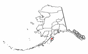
Map showing the location of Alaska's Raspberry Island. |
|||
| 日期 | ||||
| 来源 | Based on image Image:Map of Alaska.png, and modified by Kralizec!. | |||
| 作者 | (c) 2007 Dustin M. Ramsey (Kralizec!) | |||
| 授权 (二次使用本文件) |
You may NOT use this image on your own web site or anywhere else unless you release this image and any derivative works (e.g. your web site) by following the terms of one of the following licenses. Any other use will be considered a breach of copyright and I reserve the right of legal action. If you have not read the terms of these licenses or do not understand them, then do not use this image. If you would like special permission to use, license, or purchase this image or prints of this image for use in any other fashion or would simply like a copy of the original file, please contact me or email me first to ask. Note: While you are not required to do so by the license, please consider letting me know when you reuse one of my images, as a courtesy. 我,本作品著作权人,特此采用以下许可协议发表本作品:
您可以选择您需要的许可协议。 |

文件历史
点击某个日期/时间查看对应时刻的文件。
| 日期/时间 | 缩略图 | 大小 | 用户 | 备注 | |
|---|---|---|---|---|---|
| 当前 | 2007年10月27日 (六) 20:32 | | 300 × 186(6 KB) | Kralizec!(留言 | 贡献) | {{Information |Description = Map showing the location of Alaska's Raspberry Island. ---- {{Created with GIMP}} |Source = Based on image Image:Map of Alaska.png, and modified by Kralizec!. |Date |
您不可以覆盖此文件。
文件用途
没有页面使用本文件。
全域文件用途
以下其他wiki使用此文件:
- en.wikipedia.org上的用途
- zh.wikipedia.org上的用途