File:AMH-2554-NA Map of Robben Island.jpg
Jump to navigation
Jump to search

Size of this preview: 800 × 564 pixels. Other resolutions: 320 × 226 pixels | 640 × 451 pixels | 1,024 × 722 pixels | 1,280 × 903 pixels | 2,400 × 1,693 pixels.
Original file (2,400 × 1,693 pixels, file size: 525 KB, MIME type: image/jpeg)
Captions
Captions
Add a one-line explanation of what this file represents
Summary
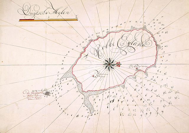
[edit]Nederlands: Kaart van Robbeneiland
English: Map of Robben Island( |
||||||||||||||||||||||||
|---|---|---|---|---|---|---|---|---|---|---|---|---|---|---|---|---|---|---|---|---|---|---|---|---|
| Author |
Nederlands: Anoniem / Anonymous
English: Anoniem / Anonymous |
|||||||||||||||||||||||
| Title |
Nederlands: Kaart van Robbeneiland
English: Map of Robben Island |
|||||||||||||||||||||||
| Description |
Nederlands: Titel in catalogus Leupe (NA): Kaart van het Robben Eyland met opgave der dieptens enz.. Aangeduid is de plaats waar het schip 'De Walvis' is vergaan": "De Walvisch / Alhier heeft men / tegens de Walvisch / 4 vadems waters" (vadem = 1,83 m, 4 vadems = 7,32 m diep). Termen aangeduid op de kaart: t Robbe Eijland, D'baas zijn woning, Vlaggemans Huijsje en Duijtsche Mijlen (7407,41 meter, schaal is 1/2 DM, dus 3704 m).
English: According to the Leupe catalogue (NA), the original title reads: Kaart van het Robben Eyland met opgave der dieptens enz. (Map of Seal Island with specification of the depths etc.). The chart marks the location where the ship 'De Walvis' (The Whale) sank, at a depth of 7.3 m. Terms indicated on the chart: t Robbe Eijland (Seal Island), D'baas zijn woning (House of the Boss), Vlaggemans Huijsje (Small house of the man with the flag) and Duijtsche Mijlen (German miles, 7407.41 meter, the scale bar indicates 1/2 DM = 3704 m). |
|||||||||||||||||||||||
| Date | circa 1731 | |||||||||||||||||||||||
| Medium |
Nederlands: ingekleurde tekening op papier
English: coloured drawing on paper |
|||||||||||||||||||||||
| Dimensions | height: 740 mm (29.13 in); width: 535 mm (21.06 in) | |||||||||||||||||||||||
| Collection |
|
|||||||||||||||||||||||
| Accession number |
NL-HaNA_4.VEL_194 (old number: VEL0194) |
|||||||||||||||||||||||
| Inscriptions |
Robbe Eyland
|
|||||||||||||||||||||||
| Notes |
English: Subjects: chart / map / plan, house, ship / vessel, compass / dial
Nederlands: Onderwerpen: plattegrond / kaart, huis / woonhuis, schip / vaartuig, kompas / windroos
English: Post: this image is related to a VOC trading post called Robbeneiland |
|||||||||||||||||||||||
| Source/Photographer |
|
|||||||||||||||||||||||

Licensing
[edit]
|
This is a faithful photographic reproduction of a two-dimensional, public domain work of art. The work of art itself is in the public domain for the following reason:
The official position taken by the Wikimedia Foundation is that "faithful reproductions of two-dimensional public domain works of art are public domain".
This photographic reproduction is therefore also considered to be in the public domain in the United States. In other jurisdictions, re-use of this content may be restricted; see Reuse of PD-Art photographs for details. | ||||
| Object location | | View this and other nearby images on: OpenStreetMap |
|---|
File history
Click on a date/time to view the file as it appeared at that time.
| Date/Time | Thumbnail | Dimensions | User | Comment | |
|---|---|---|---|---|---|
| current | 15:57, 10 June 2014 | | 2,400 × 1,693 (525 KB) | HuskyBot (talk | contribs) | == {{int:filedesc}} == {{Artwork |title = {{nl|1=Kaart van Robbeneiland}} {{en|1=Map of Robben Island}} |description = {{nl|1=Titel in catalogus Leupe (NA): ''Kaart van het Robben Eyland met opgave der dieptens... |
You cannot overwrite this file.
File usage on Commons
The following 2 pages use this file:
File usage on other wikis
The following other wikis use this file:
- Usage on avk.wikipedia.org
- Usage on en.wikipedia.org
- Usage on fr.wikipedia.org
- Usage on mt.wikipedia.org