File:AMH-2598-NA Map of Cochin.jpg
Original file (2,400 × 2,198 pixels, file size: 907 KB, MIME type: image/jpeg)
Captions
Captions
Summary[edit]
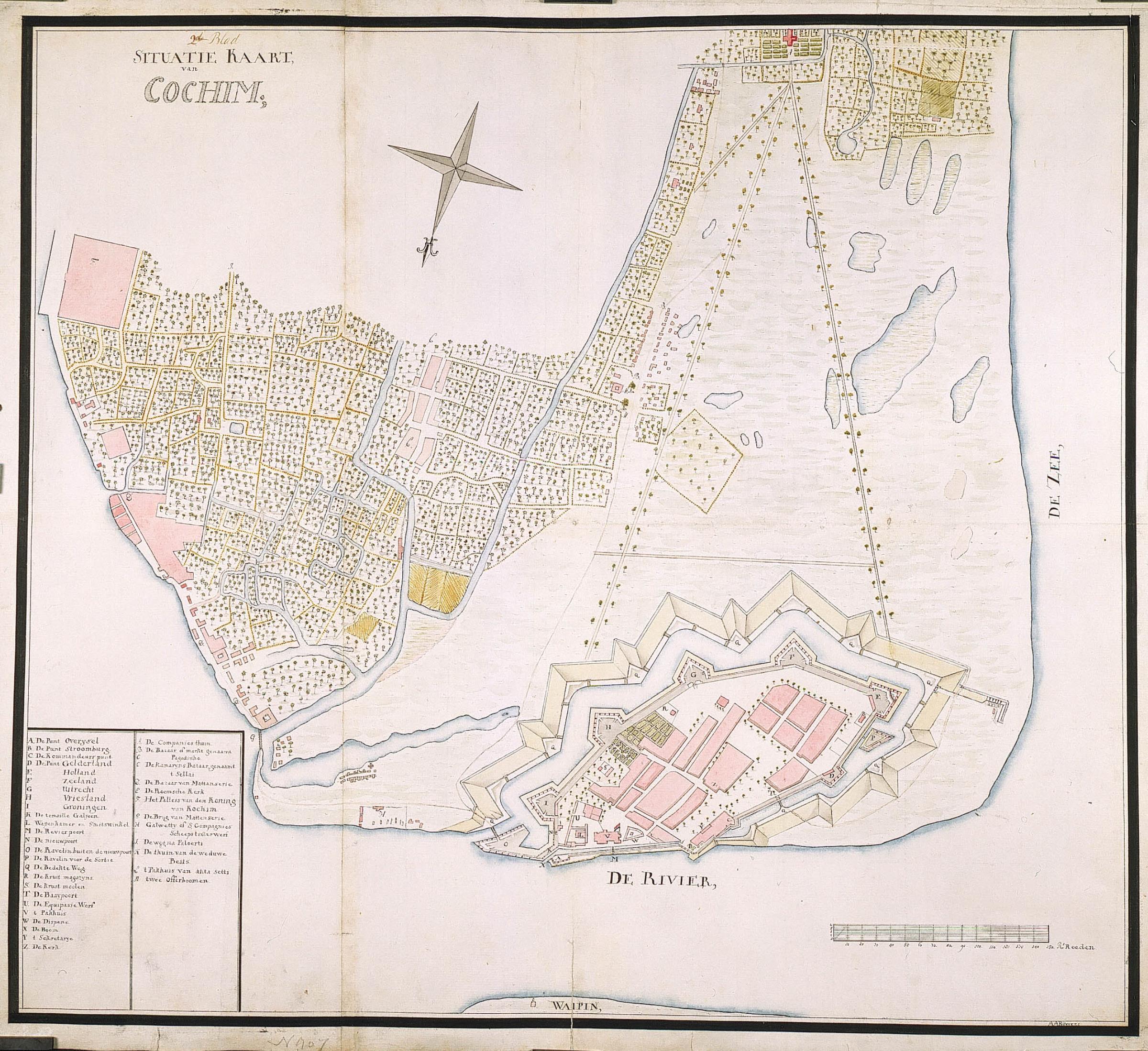
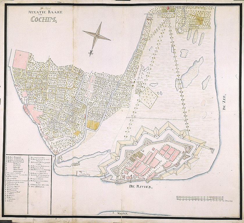
Nederlands: Kaart van Cochin
English: Map of Cochin( |
||||||||||||||||||||||||
|---|---|---|---|---|---|---|---|---|---|---|---|---|---|---|---|---|---|---|---|---|---|---|---|---|
| Author |
Nederlands: A.A. Buijskes (landmeter / kaartenmaker), I.O. Vaillant (opdrachtgever), C.A. Verhuell (opdrachtgever), J.F.L van Gravestein (opdrachtgever)
English: A.A. Buijskes (land surveyor / mapmaker), I.O. Vaillant (patron), C.A. Verhuell (patron), J.F.L van Gravestein (patron) |
|||||||||||||||||||||||
| Title |
Nederlands: Kaart van Cochin
English: Map of Cochin |
|||||||||||||||||||||||
| Description |
Nederlands: Titel catalogus Leupe (NA): Situatie Kaart van Cochim.
Legenda: A-Z; A-M Bijschrift in catalogus Leupe: Behoort bij de rapporten van de militaire commissie naar de Oost 1789-1792, o.l.v. J.O. Vaillant, C.A. Verhuell en J.F.L. van Gravenstein. Zie NA Staatssecretarie inv. nr. 1910-1932; Collectie Verhuell nrs. 7-45. Links boven de titel: 2de blad. Notities verso: Cochin nr. 2; [Gedrukt etiket] nr. 507. Topografische namen vermeld op deze kaart: punt Overysel, punt Stroomburg, Kommandeurspunt, punt Gelderland, Punt Holland, punt Zeeland, punt Uitrecht, punt Vriesland, punt Groningen, Galwetty of S Compagnies scheepstimmerwerf.English: According to catalogue Leupe (NA) the original title reads: Situatie Kaart van Cochim.
Key: A-Z; A-M Caption in Leupe catalogue: Behoort bij de rapporten van de militaire commissie naar de Oost 1789-1792, o.l.v. J.O. Vaillant, C.A. Verhuell en J.F.L. van Gravenstein. Zie NA Staatssecretarie inv. nr. 1910-1932; Collectie Verhuell nrs. 7-45. Left above title: 2de blad. Notes on reverse: Cochin nr. 2; [Printed label] nr. 507. Topographical names mentioned on this chart: punt Overysel, punt Stroomburg, Kommandeurspunt, punt Gelderland, Punt Holland, punt Zeeland, punt Uitrecht, punt Vriesland, punt Groningen, Galwetty of S Compagnies scheepstimmerwerf. |
|||||||||||||||||||||||
| Date | between 1700 and 1800 | |||||||||||||||||||||||
| Medium |
Nederlands: ingekleurde tekening op papier
English: coloured drawing on paper |
|||||||||||||||||||||||
| Dimensions | height: 73 cm (28.7 in); width: 65 cm (25.5 in) | |||||||||||||||||||||||
| Collection |
|
|||||||||||||||||||||||
| Accession number |
NL-HaNA_4.VEL_907 (old number: VEL0907) |
|||||||||||||||||||||||
| Inscriptions |
Situatie Kaart van Cochim;
author: A.A. Buijskes |
|||||||||||||||||||||||
| Notes |
English: Subjects: chart / map / plan, bird's-eye view / elevation, elevation / bird's-eye view, church / parsonage, garden / ornamental garden, warehouse, shipyard, bazaar / market, compass / dial, banderole / cartouche / ornamentation
Nederlands: Onderwerpen: plattegrond / kaart, vogelvlucht / opstand, opstand / vogelvlucht, kerk / pastorie, tuin / siertuin, pakhuis, scheeps- / timmerwerf, bazaar / markt, kompas / windroos, banderol / cartouche / versiering
English: Post: this image is related to a VOC trading post called Cochin |
|||||||||||||||||||||||
| Source/Photographer |
|
|||||||||||||||||||||||
| Permission (Reusing this file) |
|
|||||||||||||||||||||||
._Commissaris-generaal_(1816-19)_Rijksmuseum_SK-A-3794.jpeg)

| Object location | | View this and other nearby images on: OpenStreetMap |
|---|
File history
Click on a date/time to view the file as it appeared at that time.
| Date/Time | Thumbnail | Dimensions | User | Comment | |
|---|---|---|---|---|---|
| current | 16:05, 10 June 2014 | | 2,400 × 2,198 (907 KB) | HuskyBot (talk | contribs) | == {{int:filedesc}} == {{Artwork |title = {{nl|1=Kaart van Cochin}} {{en|1=Map of Cochin}} |description = {{nl|1=Titel catalogus Leupe (NA): ''Situatie Kaart van Cochim''. Legenda: A-Z; A-M Bijschrift in cata... |
You cannot overwrite this file.
File usage on Commons
The following page uses this file:
File usage on other wikis
The following other wikis use this file:
- Usage on nl.wikipedia.org