File:AMH-4664-NA Map of the city and fort at Japara.jpg
Original file (2,400 × 1,743 pixels, file size: 530 KB, MIME type: image/jpeg)
Captions
Captions
Summary
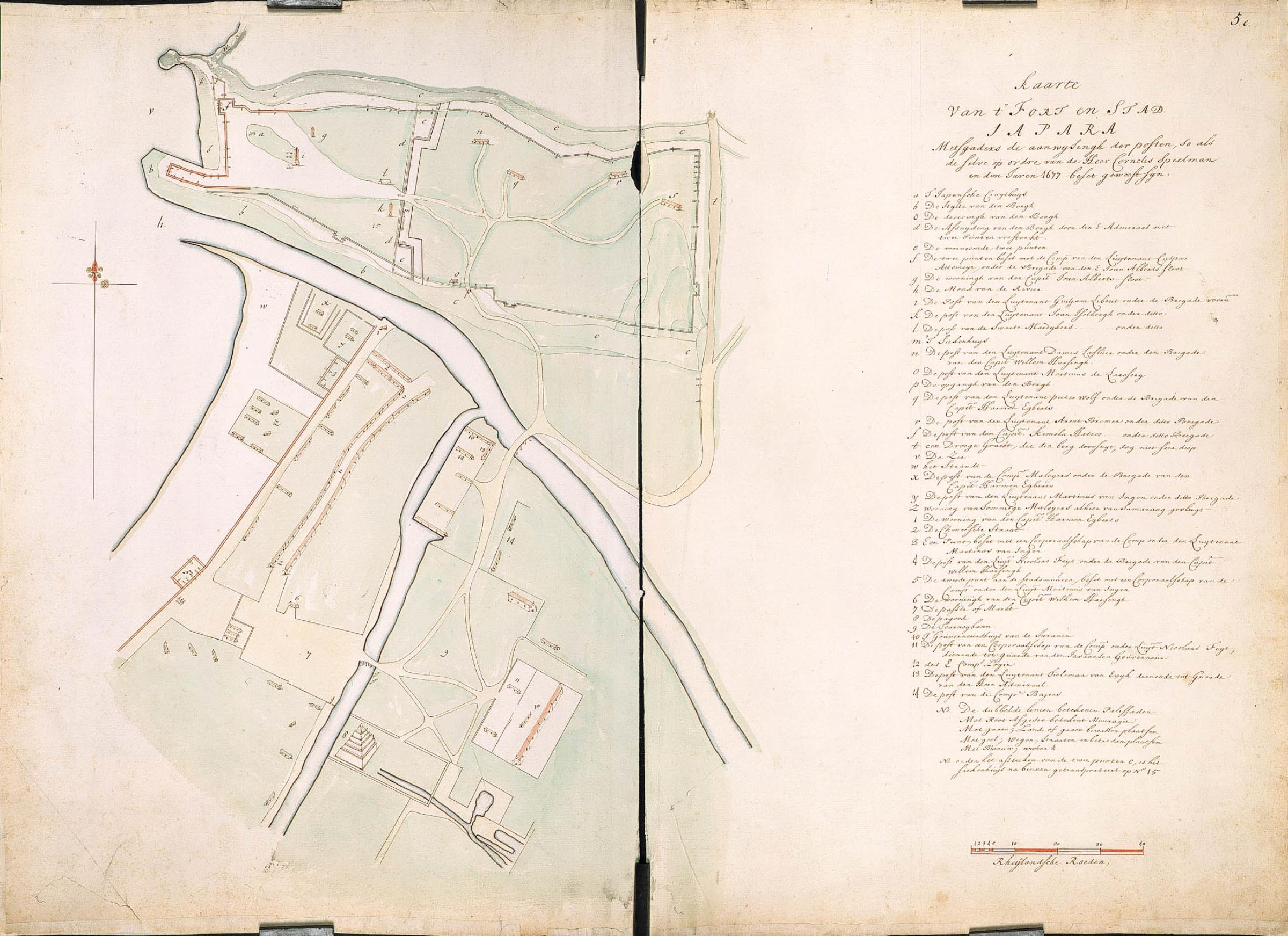
[edit]Nederlands: Kaart van de stad en het fort van Japara
                     English:  Map of the city and fort at Japara
                     Bahasa Indonesia:  Peta kota dan benteng di Jepara
( |
||||||||||||||||||||||||||
|---|---|---|---|---|---|---|---|---|---|---|---|---|---|---|---|---|---|---|---|---|---|---|---|---|---|---|
| Author |
Nederlands: Isaac de Graaff (landmeter / kaartenmaker)
English: Isaac de Graaff (land surveyor / mapmaker) |
|||||||||||||||||||||||||
| Title |
Nederlands: Kaart van de stad en het fort van Japara
English: Map of the city and fort at Japara
Bahasa Indonesia: Peta kota dan benteng di Jepara |
|||||||||||||||||||||||||
| Description |
Nederlands: Titel catalogus Leupe (NA): Kaarte van 't Fort en stad Japara, mitsgaders de aanwysing der posten, so als deselve op ordre van de heer Cornelis Speelman in den Jare 1677 beset geweest zyn.
Datering van de situatie betreft 1677. Op de middenvouw zijn beide helften aan elkaar geplakt geweest, maar weer losgeraakt zodat de kaart uit twee stukken bestaat. Rechtsboven genummerd: 5.e.English: According to the Leupe catalogue (NA), the original title reads: Kaarte van 't Fort en stad Japara, mitsgaders de aanwysing der posten, so als deselve op ordre van de heer Cornelis Speelman in den Jare 1677 beset geweest zyn.
The state of affairs is dated 1677. Along the centre fold the two halves were stuck together, but since then they have come unstuck so that the map consists of two pieces. Numbered top right: 5.e.Bahasa Indonesia: Menurut katalog Leupe (NA), judul aslinya berbunyi: Kaarte van 't Fort en stad Japara, mitsgaders de aanwysing der posten, so als deselve op ordre van de heer Cornelis Speelman in den Jare 1677 beset geweest zyn.
Tertulis tahun 1677. Sepanjang lipatan tengah, kedua bagian itu saling menempel. Tetapi dari sejak itu, mereka terlepas sehingga peta terdiri dari dua bagian. Diberi nomor di kanan atas: 5.e. |
|||||||||||||||||||||||||
| Date | between 1690 and 1705 | |||||||||||||||||||||||||
| Medium |
Nederlands: ingekleurde tekening op papier
English: coloured drawing on paper
Bahasa Indonesia: gambar berwarna di atas kertas |
|||||||||||||||||||||||||
| Dimensions | height: 75 cm (29.5 in); width: 53 cm (20.8 in) | |||||||||||||||||||||||||
| Collection |
|
|||||||||||||||||||||||||
| Accession number |
NL-HaNA_4.VEL_1271 (old number: VEL1271) |
|||||||||||||||||||||||||
| Inscriptions |
Kaarte van 't Fort en stad Japara
|
|||||||||||||||||||||||||
| Notes |
English: Subjects: key, chart / map / plan, fortification
Nederlands: Onderwerpen: legenda, plattegrond / kaart, vesting
English: Post: this image is related to a VOC trading post called Jepara |
|||||||||||||||||||||||||
| Source/Photographer |
|
|||||||||||||||||||||||||
| Permission (Reusing this file) |
|
|||||||||||||||||||||||||

| Object location | | View this and other nearby images on: OpenStreetMap |
|---|
File history
Click on a date/time to view the file as it appeared at that time.
| Date/Time | Thumbnail | Dimensions | User | Comment | |
|---|---|---|---|---|---|
| current | 16:56, 10 June 2014 | | 2,400 × 1,743 (530 KB) | HuskyBot (talk | contribs) | == {{int:filedesc}} == {{Artwork |title = {{nl|1=Kaart van de stad en het fort van Japara}} {{en|1=Map of the city and fort at Japara}} |description = {{nl|1=Titel catalogus Leupe (NA): ''Kaarte van 't Fort en... |
You cannot overwrite this file.
File usage on Commons
The following page uses this file:
File usage on other wikis
The following other wikis use this file:
- Usage on nl.wikipedia.org