File:AMH-5617-NA Map of the Priang lands, that is, part of the northern coast of Java.jpg

Original file (1,708 × 2,400 pixels, file size: 784 KB, MIME type: image/jpeg)
Captions
Captions
Summary
[edit]| Author |
Nederlands: Anoniem / Anonymous (landmeter / kaartenmaker)
English: Anoniem / Anonymous (land surveyor / mapmaker) |
|||||||||||||||||||||||
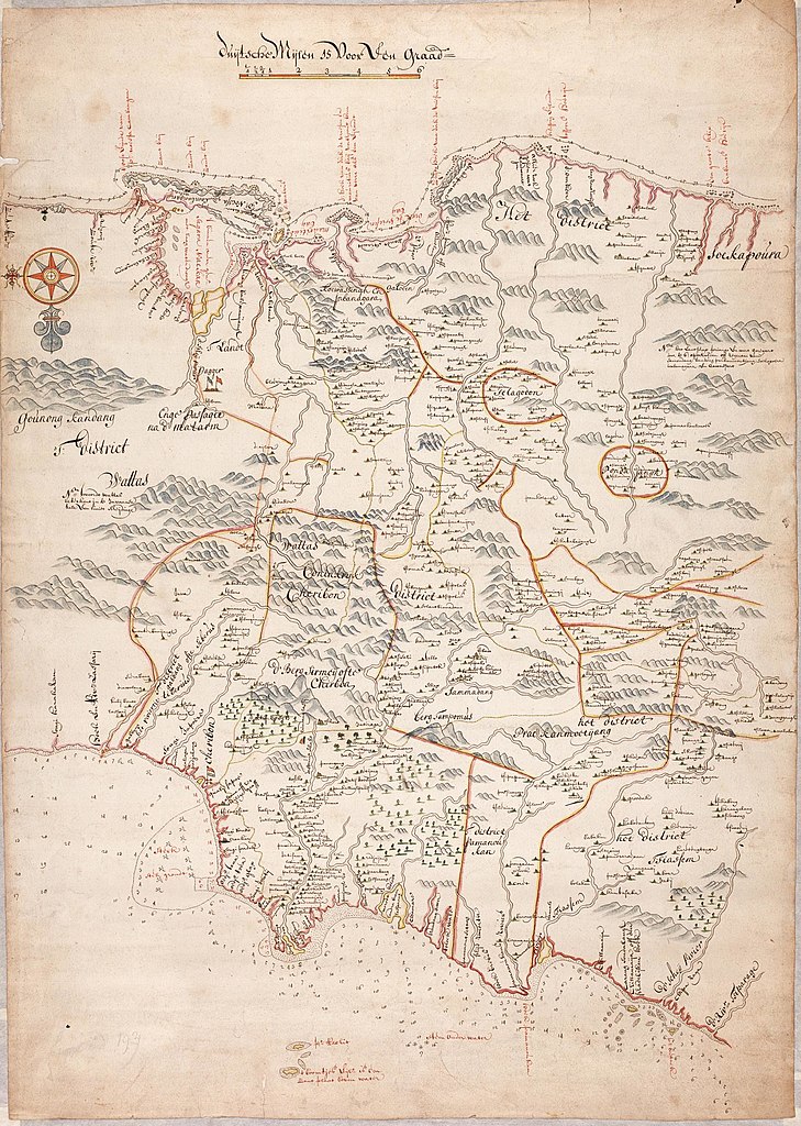
| Title |
Nederlands: Kaart van de Priangse landen ofwel een gedeelte van de noordkust van Java
English: Map of the Priang lands, that is, part of the northern coast of Java
Bahasa Indonesia: Peta tanah Priangan, yaitu bagian dari pantai utara Jawa |
|||||||||||||||||||||||
| Description |
Nederlands: Titel catalogus Leupe (NA): Kaart van "de Priangse landen".
Bijzonderheden: het formaat is exclusief een strook aangeplakt Japans papier. Notities verso: No. 20 De Priangse Landen / 113 [op een klein rond etiketje] / No. 3: / 39. [in potlood] / 1190 [in potlood] / 1720 [in potlood, staat onder 1190 geschreven].English: Title in the Leupe catalogue (NA): Kaart van "de Priangse landen".
Particulars: the measurements of the map exclude a strip of Japanese paper that has been pasted on. Notes on reverse: No. 20 De Priangse Landen / 113 [on a small round label] / No. 3: / 39. [in pencil] / 1190 [in pencil] / 1720 [in pencil, written below 1190].Bahasa Indonesia: Judul dalam katalog Leupe (AN): Kaart van "de Priangse landen".
Terkhusus: ukuran peta tidak termasuk secarik kertas Jepang yang telah ditempel. Catatan di belakang: No. 20 De Priangse Landen / 113 [dalam label bulat kecil] / No. 3: / 39. [dengan pensil] / 1190 [dengan pensil] / 1720 [dengan pensil, ditulis di bawah angka 1190]. |
|||||||||||||||||||||||
| Date | between 1650 and 1750 | |||||||||||||||||||||||
| Medium |
Nederlands: ingekleurde tekening op papier
English: coloured drawing on paper
Bahasa Indonesia: gambar berwarna di atas kertas |
|||||||||||||||||||||||
| Dimensions | height: 52 cm (20.4 in); width: 73 cm (28.7 in) | |||||||||||||||||||||||
| Collection |
|
|||||||||||||||||||||||
| Accession number |
NL-HaNA_4.VELH_481 (old number: VELH0481) |
|||||||||||||||||||||||
| Inscriptions |
-
|
|||||||||||||||||||||||
| Notes |
English: Subjects: chart / map / plan, compass / dial
Nederlands: Onderwerpen: plattegrond / kaart, kompas / windroos
English: Post: this image is related to a VOC trading post called Cirebon |
|||||||||||||||||||||||
| Source/Photographer |
|
|||||||||||||||||||||||
| Permission (Reusing this file) |
|
|||||||||||||||||||||||

| Object location | | View this and other nearby images on: OpenStreetMap |
|---|
File history
Click on a date/time to view the file as it appeared at that time.
| Date/Time | Thumbnail | Dimensions | User | Comment | |
|---|---|---|---|---|---|
| current | 08:43, 11 June 2014 | | 1,708 × 2,400 (784 KB) | HuskyBot (talk | contribs) | == {{int:filedesc}} == {{Artwork |title = {{nl|1=Kaart van de Priangse landen ofwel een gedeelte van de noordkust van Java}} {{en|1=Map of the Priang lands, that is, part of the northern coast of Java}} |description... |
You cannot overwrite this file.
File usage on Commons
The following page uses this file: