File:AMH-6062-NA Map of the Persian Gulf.jpg
Original file (2,400 × 1,699 pixels, file size: 460 KB, MIME type: image/jpeg)
Captions
Captions
Summary[edit]
Nederlands: Kaart van Persische Golf
English: Map of the Persian Gulf( |
||||||||||||||||||||||||||
|---|---|---|---|---|---|---|---|---|---|---|---|---|---|---|---|---|---|---|---|---|---|---|---|---|---|---|
| Author |
Nederlands: Isaac de Graaff (landmeter / kaartenmaker)
English: Isaac de Graaff (land surveyor / mapmaker) |
|||||||||||||||||||||||||
| Title |
Nederlands: Kaart van Persische Golf
English: Map of the Persian Gulf |
|||||||||||||||||||||||||
| Description |
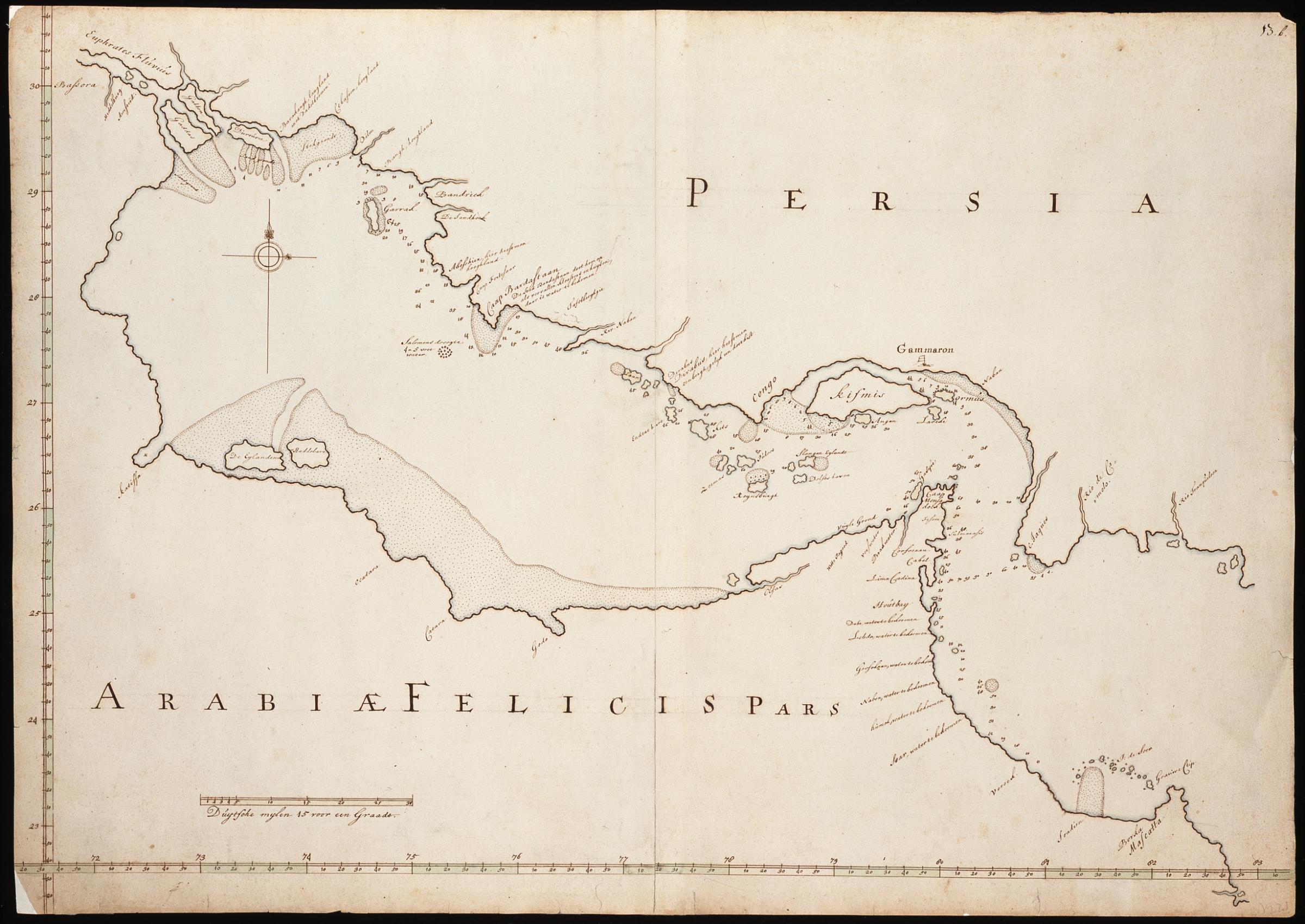
Nederlands: Titel catalogus Leupe (NA): Kaart van een gedeelte van den Persische Golf, van Mascate tot Bassora en van den Euphraat tot Rio Tranqueloca.
Rechtsboven genummerd 13.b.. Notities verso: 20 [met potlood in rechterbovenhoek] . De kaart toont Persia, Arabia Felicis Pars en de golf van Persie met eilandnamen en plaatsnamen, zoals Euphrates Fluvius, Bafsora, Salomond droogte 4 a 5 voet water, De Eijlanden,Congo, Gammaron, Kifmis, Borka, Mascatta. Bij Gammaron is een vlag getekend. Linksonder is de schaalverdeling Duytsche mylen 15 voor een Graadt.English: Title in the Leupe catalogue (NA): Kaart van een gedeelte van den Persische Golf, van Mascate tot Bassora en van den Euphraat tot Rio Tranqueloca.
Numbered top right 13.b.. Notes on reverse: 20 [in pencil, in the upper right corner] . The map shows Persia, Arabia Felicis Pars and the Persian Gulf with the names of islands and places such as Euphrates Fluvius, Bafsora, Salomond droogte 4 a 5 voet water, De Eijlanden,Congo, Gammaron, Kifmis, Borka, Mascatta. A flag has been drawn at Gammaron. Bottom left is the scale Duytsche mylen 15 voor een Graadt. |
|||||||||||||||||||||||||
| Date | between 1690 and 1743 | |||||||||||||||||||||||||
| Medium |
Nederlands: pen en penseel op papier
English: pen and brush on paper |
|||||||||||||||||||||||||
| Dimensions | height: 74.5 cm (29.3 in); width: 52.5 cm (20.6 in) | |||||||||||||||||||||||||
| Collection |
|
|||||||||||||||||||||||||
| Accession number |
NL-HaNA_4.VEL_221 (old number: VEL0221) |
|||||||||||||||||||||||||
| Inscriptions |
Persia / Arabiae Felicis Pars
|
|||||||||||||||||||||||||
| Notes |
English: Subjects: flora, fortification, chart / map / plan, compass / dial
Nederlands: Onderwerpen: flora, vesting, plattegrond / kaart, kompas / windroos
English: Post: this image is related to a VOC trading post called Hormoz |
|||||||||||||||||||||||||
| Source/Photographer |
|
|||||||||||||||||||||||||
| Permission (Reusing this file) |
|
|||||||||||||||||||||||||

| Object location | | View this and other nearby images on: OpenStreetMap |
|---|
File history
Click on a date/time to view the file as it appeared at that time.
| Date/Time | Thumbnail | Dimensions | User | Comment | |
|---|---|---|---|---|---|
| current | 08:52, 11 June 2014 | | 2,400 × 1,699 (460 KB) | HuskyBot (talk | contribs) | == {{int:filedesc}} == {{Artwork |title = {{nl|1=Kaart van Persische Golf}} {{en|1=Map of the Persian Gulf}} |description = {{nl|1=Titel catalogus Leupe (NA): ''Kaart van een gedeelte van den Persische Golf, va... |
You cannot overwrite this file.
File usage on Commons
The following page uses this file: