File:AMH-6596-NA Map of Candia and environs.jpg
Jump to navigation
Jump to search

Size of this preview: 800 × 564 pixels. Other resolutions: 320 × 226 pixels | 640 × 451 pixels | 1,024 × 722 pixels | 1,280 × 902 pixels | 2,560 × 1,805 pixels | 6,538 × 4,609 pixels.
Original file (6,538 × 4,609 pixels, file size: 5.85 MB, MIME type: image/jpeg)
Captions
Captions
Add a one-line explanation of what this file represents
Summary[edit]
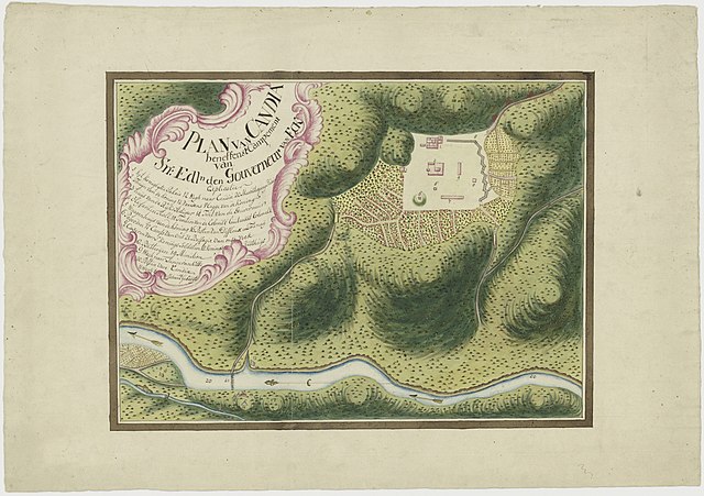
Nederlands: Plattegrond van Candia en omgeving
English: Map of Candia and environs( |
||||||||||||||||||||||||
|---|---|---|---|---|---|---|---|---|---|---|---|---|---|---|---|---|---|---|---|---|---|---|---|---|
| Author |
Nederlands: Anoniem / Anonymous (tekenaar)
English: Anoniem / Anonymous (draughtsman) |
|||||||||||||||||||||||
| Title |
Nederlands: Plattegrond van Candia en omgeving
English: Map of Candia and environs |
|||||||||||||||||||||||
| Description |
Nederlands: Titel catalogus Leupe (NA): Plan van Candia beneffens 't Campement van S:n Edln den Gouverneur van Eck.
Notities verso: 32 [in potlood]. Legenda: 1-19English: Title in the Leupe catalogue (NA): Plan van Candia beneffens 't Campement van S:n Edln den Gouverneur van Eck.
Notes on reverse: 32 [in pencil]. Key: 1-19 |
|||||||||||||||||||||||
| Date | circa 1765 | |||||||||||||||||||||||
| Medium |
Nederlands: ingekleurde tekening op papier
English: coloured drawing on paper |
|||||||||||||||||||||||
| Dimensions | height: 54.5 cm (21.4 in); width: 38 cm (14.9 in) | |||||||||||||||||||||||
| Collection |
|
|||||||||||||||||||||||
| Accession number |
NL-HaNA_4.VELH_346 (old number: VELH0346) |
|||||||||||||||||||||||
| Inscriptions |
Plan van Candia beneffens 't Campement van S:n Edln den Gouverneur van Eck
|
|||||||||||||||||||||||
| Notes |
English: Subjects: palace, banderole / cartouche / ornamentation, pagoda / temple, survey / view, key, chart / map / plan, menagerie / stable
Nederlands: Onderwerpen: paleis, banderol / cartouche / versiering, pagode / tempel, overzicht / aanzicht, legenda, plattegrond / kaart, menagerie / stal
English: Post: this image is related to a VOC trading post called Kandy |
|||||||||||||||||||||||
| Source/Photographer |
|
|||||||||||||||||||||||
| Permission (Reusing this file) |
|
|||||||||||||||||||||||

| Object location | | View this and other nearby images on: OpenStreetMap |
|---|
File history
Click on a date/time to view the file as it appeared at that time.
| Date/Time | Thumbnail | Dimensions | User | Comment | |
|---|---|---|---|---|---|
| current | 13:11, 21 July 2015 | | 6,538 × 4,609 (5.85 MB) | Timmietovenaar (talk | contribs) | Higher resolution image, without an upload error the last image had |
| 09:36, 11 June 2014 |  | 2,400 × 1,803 (616 KB) | HuskyBot (talk | contribs) | == {{int:filedesc}} == {{Artwork |title = {{nl|1=Plattegrond van Candia en omgeving}} {{en|1=Map of Candia and environs}} |description = {{nl|1=Titel catalogus Leupe (NA): ''Plan van Candia beneffens 't Campeme... |
You cannot overwrite this file.
File usage on Commons
The following page uses this file:
File usage on other wikis
The following other wikis use this file:
- Usage on ca.wikipedia.org
- Usage on en.wikipedia.org
- Usage on nl.wikipedia.org
- Usage on sl.wikipedia.org