File:AMH-6741-NA Map of Anjouan.jpg
Original file (2,400 × 1,560 pixels, file size: 729 KB, MIME type: image/jpeg)
Captions
Captions
Summary
[edit]| Nederlands: Kaart van Anjouan
English: Map of Anjouan ( |
||||||||||||||||||||||||
|---|---|---|---|---|---|---|---|---|---|---|---|---|---|---|---|---|---|---|---|---|---|---|---|---|
| Author |
Nederlands: Anoniem / Anonymous (landmeter / kaartenmaker)
English: Anoniem / Anonymous (land surveyor / mapmaker) |
|||||||||||||||||||||||
| Title |
Nederlands: Kaart van Anjouan
English: Map of Anjouan |
|||||||||||||||||||||||
| Description |
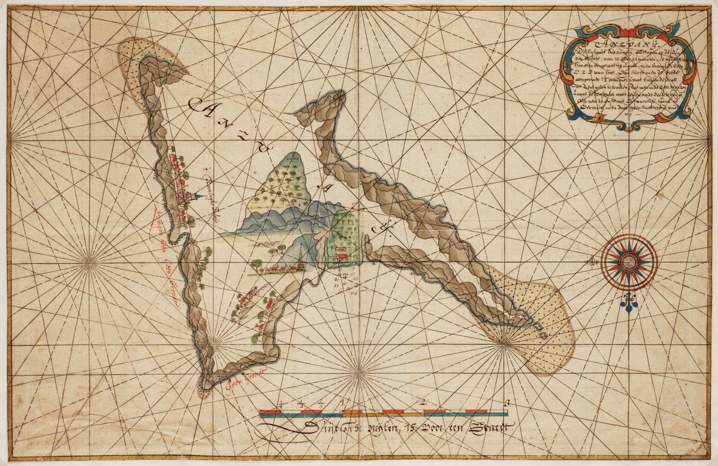
Nederlands: Titel catalogus Leupe (NA): Kaart van de kusten van het ieland "Anzuany" of Anjoan in de Comoren. Met loodingen.
Dit Eylandt Anzuanij, Gelegen op de Zuyder breete, van 12. Gr. 24 minuten Is Redelyk hooch en berghachtig Landt, men brengt De Berg O.Z.O van sich, dan heeft men de Rede [?] 1 1/2 musquetschoot buiten de wall voor dien gelett te worden, dat men in de Z.O.O. [?] lou langs de [?] moet zeijlen, om de Reede te krijge: Also aan de Oostkant Beswaerlijk kant is [?] men daer geen Anckergrond vindt etc. Deze afbeelding komt overeen met de kaart bij Valentijn, Oud en Nieuw Oost-Indien, deel V, tweede stuk, pagina 149. Kaart van Anjouan. Anzuanij. Bijzonderheden: de kaart maakt deel uit van de Atlas Vingboons.English: Title in the Leupe catalogue (NA): Kaart van de kusten van het ieland "Anzuany" of Anjoan in de Comoren. Met loodingen.
Dit Eylandt Anzuanij, Gelegen op de Zuyder breete, van 12. Gr. 24 minuten Is Redelyk hooch en berghachtig Landt, men brengt De Berg O.Z.O van sich, dan heeft men de Rede [?] 1 1/2 musquetschoot buiten de wall voor dien gelett te worden, dat men in de Z.O.O. [?] lou langs de [?] moet zeijlen, om de Reede te krijge: Also aan de Oostkant Beswaerlijk kant is [?] men daer geen Anckergrond vindt etc. This image corresponds to the map accompanying Valentijn, Oud en Nieuw Oost-Indien, volume V, second part, page 149. Map of Anjouan. Anzuanij. Remarks: the map is contained in the Vingboons Atlas. |
|||||||||||||||||||||||
| Date | circa 1665 | |||||||||||||||||||||||
| Medium |
Nederlands: aquarel/waterverf op papier
English: watercolour on paper |
|||||||||||||||||||||||
| Dimensions | height: 32.5 cm (12.7 in); width: 49.5 cm (19.4 in) | |||||||||||||||||||||||
| Collection |
|
|||||||||||||||||||||||
| Accession number |
NL-HaNA_4.VELH_619.15 (old number: VELH0619.15) |
|||||||||||||||||||||||
| Inscriptions |
Anzuanij
|
|||||||||||||||||||||||
| Notes |
English: Subjects: banderole / cartouche / ornamentation, compass / dial, palace, house, building, chart / map / plan, mosque
Nederlands: Onderwerpen: banderol / cartouche / versiering, kompas / windroos, paleis, huis / woonhuis, gebouw, plattegrond / kaart, moskee
English: Post: this image is related to a VOC trading post called Nzwani |
|||||||||||||||||||||||
| Source/Photographer |
|
|||||||||||||||||||||||
| Permission (Reusing this file) |
|
|||||||||||||||||||||||

| Object location | | View this and other nearby images on: OpenStreetMap |
|---|
File history
Click on a date/time to view the file as it appeared at that time.
| Date/Time | Thumbnail | Dimensions | User | Comment | |
|---|---|---|---|---|---|
| current | 09:43, 11 June 2014 | | 2,400 × 1,560 (729 KB) | HuskyBot (talk | contribs) | == {{int:filedesc}} == {{Artwork |title = {{nl|1=Kaart van Anjouan}} {{en|1=Map of Anjouan}} |description = {{nl|1=Titel catalogus Leupe (NA): ''Kaart van de kusten van het ieland "Anzuany" of Anjoan in de Como... |
You cannot overwrite this file.
File usage on Commons
The following page uses this file: