File:AMH-7705-NA Floor plan of the Vredenburg fort at Komenda.jpg

Original file (2,400 × 1,886 pixels, file size: 291 KB, MIME type: image/jpeg)
Captions
Captions
Summary
[edit]Nederlands: Plattegrond van het fort Vredenburg te Komenda
English: Floor plan of the Vredenburg fort at Komenda( |
||||||||||||||||||||||||
|---|---|---|---|---|---|---|---|---|---|---|---|---|---|---|---|---|---|---|---|---|---|---|---|---|
| Author |
Nederlands: Anoniem / Anonymous (landmeter / kaartenmaker)
English: Anoniem / Anonymous (land surveyor / mapmaker) |
|||||||||||||||||||||||
| Title |
Nederlands: Plattegrond van het fort Vredenburg te Komenda
English: Floor plan of the Vredenburg fort at Komenda |
|||||||||||||||||||||||
| Description |
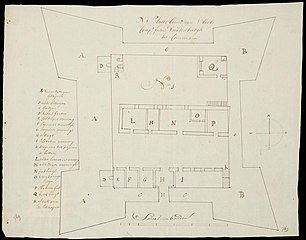
Nederlands: Plattegrond van het fort Vredenburg te Komenda.
Er is geen titel in de catalogus Leupe (NA). N:1 Platte Grond van S: Edele Comp: fortres Vreedenburgh tot Commanij. Legenda A tot en met R. Linksonder en rechtsonder: 769 [in potlood]. Deze kaart maakt deel uit van een serie aanzichten en plattegronden van fort Vredenburg te Komenda in het Nationaal Archief in Den Haag. Tot de serie behoren de inventarisnummers VEL0679, VEL0679A, VEL0679B, VEL0679C en VEL0679D.English: Floor plan of the Vredenburg fort at Komenda.
No title is given in the Leupe catalogue (NA). N:1 Platte Grond van S: Edele Comp: fortres Vreedenburgh tot Commanij. Key A through R. Bottom left and bottom right: 769 [in pencil]. This item forms part of a series of views and floor plans of the Vredenburg fort at Komenda held by the National Archives in The Hague. The series comprises the inventory numbers VEL0679, VEL0679A, VEL0679B, VEL0679C and VEL0679D. |
|||||||||||||||||||||||
| Date | between 1700 and 1800 | |||||||||||||||||||||||
| Medium |
Nederlands: pen op papier
English: pen on paper |
|||||||||||||||||||||||
| Dimensions | height: 48.5 cm (19 in); width: 38 cm (14.9 in) | |||||||||||||||||||||||
| Collection |
|
|||||||||||||||||||||||
| Accession number |
NL-HaNA_4.VEL_769C (old number: VEL0769C) |
|||||||||||||||||||||||
| Inscriptions |
N:1 Platte Grond van S: Edele Comp: fortres Vreedenburgh tot Commanij
|
|||||||||||||||||||||||
| Notes |
English: Subjects: chart / map / plan, fortification, building, key, compass / dial
Nederlands: Onderwerpen: plattegrond / kaart, vesting, gebouw, legenda, kompas / windroos
English: Post: this image is related to a WIC trading post called Komenda |
|||||||||||||||||||||||
| Source/Photographer |
|
|||||||||||||||||||||||
| Permission (Reusing this file) |
|
|||||||||||||||||||||||

| Object location | | View this and other nearby images on: OpenStreetMap |
|---|
File history
Click on a date/time to view the file as it appeared at that time.
| Date/Time | Thumbnail | Dimensions | User | Comment | |
|---|---|---|---|---|---|
| current | 10:11, 11 June 2014 | | 2,400 × 1,886 (291 KB) | HuskyBot (talk | contribs) | == {{int:filedesc}} == {{Artwork |title = {{nl|1=Plattegrond van het fort Vredenburg te Komenda}} {{en|1=Floor plan of the Vredenburg fort at Komenda}} |description = {{nl|1=Plattegrond van het fort Vredenburg... |
You cannot overwrite this file.
File usage on Commons
The following page uses this file: