File:ATE-network 3.svg
Jump to navigation
Jump to search

Size of this PNG preview of this SVG file: 445 × 599 pixels. Other resolutions: 178 × 240 pixels | 356 × 480 pixels | 570 × 768 pixels | 760 × 1,024 pixels | 1,520 × 2,048 pixels | 1,063 × 1,432 pixels.
Original file (SVG file, nominally 1,063 × 1,432 pixels, file size: 369 KB)
Captions
Captions
Add a one-line explanation of what this file represents
Summary
[edit]
| Description |
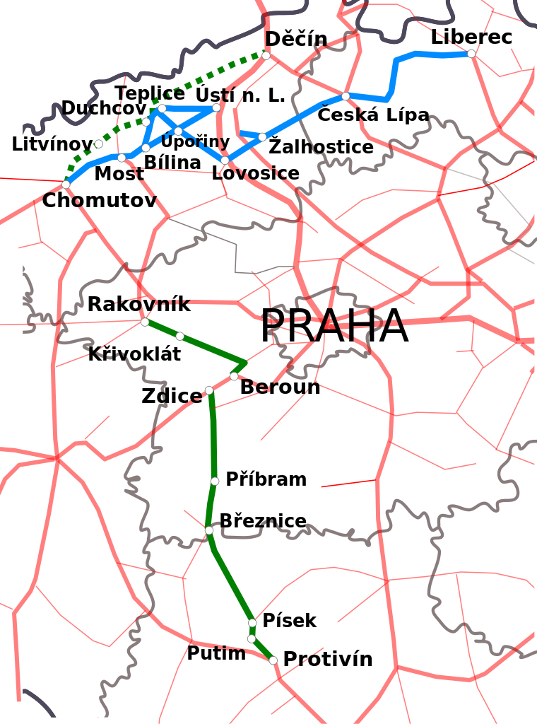
Čeština: Síť železničních tratí společnosti Aussig-Teplitzer Eisenbahn (ATE). Modře tratě postavené a provozované společností ATE, zeleně státní tratě provozované společností ATE, červeně ostatní. |
| Date | |
| Source |
This file was derived from: Railway network Czech Republic.svg: |
| Author |
|
| This is a retouched picture, which means that it has been digitally altered from its original version. Modifications: Vyznačení tratí postavených a provozovaných společností Aussig-Teplitzer Eisenbahn (ATE). The original can be viewed here: Railway network Czech Republic.svg:
|
Licensing
[edit]
I, the copyright holder of this work, hereby publish it under the following licenses:

|
Permission is granted to copy, distribute and/or modify this document under the terms of the GNU Free Documentation License, Version 1.2 or any later version published by the Free Software Foundation; with no Invariant Sections, no Front-Cover Texts, and no Back-Cover Texts. A copy of the license is included in the section entitled GNU Free Documentation License. |
This file is licensed under the Creative Commons Attribution 4.0 International license.
- You are free:
- to share – to copy, distribute and transmit the work
- to remix – to adapt the work
- Under the following conditions:
- attribution – You must give appropriate credit, provide a link to the license, and indicate if changes were made. You may do so in any reasonable manner, but not in any way that suggests the licensor endorses you or your use.
You may select the license of your choice.
File history
Click on a date/time to view the file as it appeared at that time.
| Date/Time | Thumbnail | Dimensions | User | Comment | |
|---|---|---|---|---|---|
| current | 12:50, 24 January 2017 | | 1,063 × 1,432 (369 KB) | Jann (talk | contribs) | Vyznačena trať Děčín - Duchcov - Chomutov |
| 21:43, 23 January 2017 |  | 1,063 × 1,432 (432 KB) | Jann (talk | contribs) | {{Information |Description ={{cs|1=Síť železničních tratí společnosti Aussig-Teplitzer Eisenbahn (ATE). Modře tratě postavené a provozované společností ATE, zeleně státní tratě provozované společností ATE, červeně ostatní.}} |... |
You cannot overwrite this file.
File usage on Commons
The following 6 pages use this file:
- User:Chumwa/OgreBot/Potential transport maps/2017 January 21-31
- User:Chumwa/OgreBot/Public transport information/2017 January 21-31
- User:Chumwa/OgreBot/Transport Maps/2017 January 21-31
- User:Chumwa/OgreBot/Travel and communication maps/2017 January 21-31
- File:Tratě.svg (file redirect)
- Category:Aussig-Teplitzer Eisenbahn
File usage on other wikis
The following other wikis use this file:
- Usage on cs.wikipedia.org
- Usage on www.wikidata.org