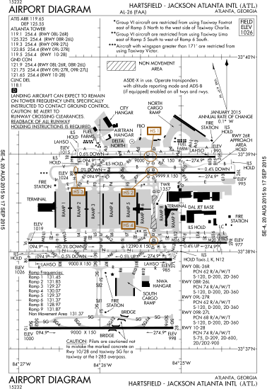
File:ATL Airport Diagram.svg
Une page de Wikimedia Commons, la médiathèque libre.
Aller à la navigation
Aller à la recherche
- Fichier
- Historique du fichier
- Utilisations locales du fichier
- Utilisations du fichier sur d’autres wikis
- Métadonnées

Taille de cet aperçu PNG pour ce fichier SVG : 378 × 548 pixels. Autres résolutions : 165 × 240 pixels | 331 × 480 pixels | 530 × 768 pixels | 706 × 1 024 pixels | 1 413 × 2 048 pixels.
Fichier d’origine (Fichier SVG, nominalement de 378 × 548 pixels, taille : 1,88 Mio)
Informations sur le fichier
Données structurées
Légendes
Légendes
Ajoutez en une ligne la description de ce que représente ce fichier
Description[modifier]
| DescriptionATL Airport Diagram.svg |
English: FAA Airport Diagram of Hartsfield-Jackson Atlanta International Airport. |
| Date | |
| Source |
FAA Airport Diagrams; note that these change every 28 days. Taken from PDF on FAA site and converted to SVG using en:Wikipedia:How to draw SVG circuits using Xcircuit. |
| Auteur | Produced by the National Aeronautical Charting Office (NACO), a department of the United States en:Federal Aviation Administration. |
Conditions d’utilisation[modifier]
| Public domainPublic domainfalsefalse |
This image or file is a work of a Federal Aviation Administration employee, taken or made as part of that person's official duties. As a work of the U.S. federal government, the image is in the public domain in the United States.
English | italiano | македонски | മലയാളം | Nederlands | русский | sicilianu | українська | 中文 | +/− |
 |
| Lieu de la prise de vue | 33° 38′ 12″ N, 84° 25′ 41″ O | Voir cet endroit et d’autres images sur : OpenStreetMap |
|---|
Historique du fichier
Cliquer sur une date et heure pour voir le fichier tel qu'il était à ce moment-là.
| Date et heure | Vignette | Dimensions | Utilisateur | Commentaire | |
|---|---|---|---|---|---|
| actuel | 26 août 2015 à 01:27 |  | 378 × 548 (1,88 Mio) | Grendelkhan (d | contributions) | Update to August 2015 version. |
| 1 mai 2013 à 20:31 |  | 378 × 548 (1,86 Mio) | Grendelkhan (d | contributions) | SVG version of FAA's PDF diagram. |
Vous ne pouvez pas remplacer ce fichier.
Utilisations locales du fichier
Les 6 pages suivantes utilisent ce fichier :
Utilisations du fichier sur d’autres wikis
Les autres wikis suivants utilisent ce fichier :
- Utilisation sur bn.wikipedia.org
- Utilisation sur ca.wikipedia.org
- Utilisation sur de.wikipedia.org
- Utilisation sur en.wikipedia.org
- Utilisation sur es.wikipedia.org
- Utilisation sur fa.wikipedia.org
- Utilisation sur fi.wikipedia.org
- Utilisation sur fr.wikipedia.org
- Utilisation sur gl.wikipedia.org
- Utilisation sur he.wikipedia.org
- Utilisation sur id.wikipedia.org
- Utilisation sur ja.wikipedia.org
- Utilisation sur ml.wikipedia.org
- Utilisation sur sco.wikipedia.org
- Utilisation sur simple.wikipedia.org
- Utilisation sur sr.wikipedia.org
- Utilisation sur ta.wikipedia.org
- Utilisation sur th.wikipedia.org
- Utilisation sur ur.wikipedia.org
- Utilisation sur zh.wikipedia.org
Métadonnées
Ce fichier contient des informations supplémentaires, probablement ajoutées par l'appareil photo numérique ou le numériseur utilisé pour le créer.
Si le fichier a été modifié depuis son état original, certains détails peuvent ne pas refléter entièrement l'image modifiée.
| Largeur | 377.513 |
|---|---|
| Hauteur | 547.93 |