File:A GOES-12 (Geostationary Satellite Server) Satellite infrared image provided by the US Naval Research Laboratory, Monterey, California (CA), shows the status of Hurricane Rita at 3- - DPLA - 6cac2c4c7b549fef4382c18a160ecb01.jpeg
Jump to navigation
Jump to search
Size of this preview: 800 × 492 pixels. Other resolutions: 320 × 197 pixels | 640 × 394 pixels | 1,024 × 630 pixels | 1,300 × 800 pixels.
Original file (1,300 × 800 pixels, file size: 640 KB, MIME type: image/jpeg)
Captions
Captions
Add a one-line explanation of what this file represents
Summary[edit]
| Creator | Department of Defense. American Forces Information Service. Defense Visual Information Center. 1994 | |||||||||||||||||||
| Title |
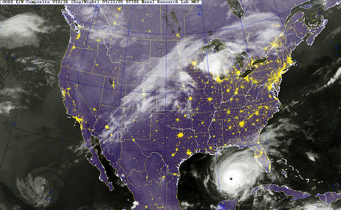
A GOES-12 (Geostationary Satellite Server) Satellite infrared image provided by the US Naval Research Laboratory, Monterey, California (CA), shows the status of Hurricane Rita at 3:30 AM EST. Rita, currently 490 miles southeast of Galveston, Texas (TX), upgraded to a Category 5 storm late Wednesday, September 21, 2005, with 170 mph winds, sparking an order for mandatory evacuations in New Orleans, Louisiana (LA), and Galveston, Texas (TX) |
|||||||||||||||||||
| Description |
The original finding aid described this photograph as: Country: United States Of America (USA) Scene Major Command Shown: U.S. NAVAL RESEARCH LABORATORY Scene Camera Operator: US Naval Research Laboratory Release Status: Released to Public |
|||||||||||||||||||
| Date | 22 September 2005 | |||||||||||||||||||
| Collection |
|
|||||||||||||||||||
| Source/Photographer |
|
|||||||||||||||||||
| Permission (Reusing this file) |
|
|||||||||||||||||||
| Standardized rights statement |
|
|||||||||||||||||||

_Satellite_infrared_image_provided_by_the_US_Naval_Research_Laboratory,_Monterey,_California_(CA),_shows_the_status_of_Hurricane_Rita_at_3-_-_DPLA_-_6cac2c4c7b549fef4382c18a160ecb01.jpeg&action=edit§ion=1)
File history
Click on a date/time to view the file as it appeared at that time.
| Date/Time | Thumbnail | Dimensions | User | Comment | |
|---|---|---|---|---|---|
| current | 20:58, 19 November 2020 | | 1,300 × 800 (640 KB) | DPLA bot (talk | contribs) | Uploading DPLA ID 6cac2c4c7b549fef4382c18a160ecb01 |
You cannot overwrite this file.
File usage on Commons
The following page uses this file:
_Satellite_infrared_image_provided_by_the_US_Naval_Research_Laboratory,_Monterey,_California_(CA),_shows_the_status_of_Hurricane_Rita_at_3-_-_DPLA_-_6cac2c4c7b549fef4382c18a160ecb01.jpeg)
_Satellite_infrared_image_provided_by_the_US_Naval_Research_Laboratory,_Monterey,_California_(CA),_shows_the_status_of_Hurricane_Rita_at_3-_-_DPLA_-_6cac2c4c7b549fef4382c18a160ecb01.jpeg&oldid=870816577)