File:A Map of the Country Inhabited by the Marattas, with the Dominions of Angria (BM 1875,0109.109).jpg

Original file (1,742 × 2,500 pixels, file size: 949 KB, MIME type: image/jpeg)
Captions
Captions
Summary[edit]
.jpg&action=edit§ion=1)
| A Map of the Country Inhabited by the Marattas, with the Dominions of Angria
( |
||||||||||||||||||||||||
|---|---|---|---|---|---|---|---|---|---|---|---|---|---|---|---|---|---|---|---|---|---|---|---|---|
| Title |
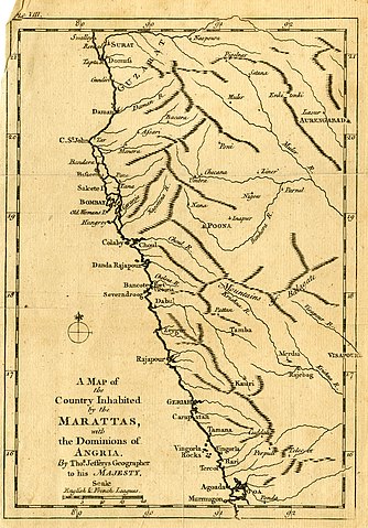
A Map of the Country Inhabited by the Marattas, with the Dominions of Angria |
|||||||||||||||||||||||
| Description |
English: Map of the West Indian Coast, from Surat in the North to Goa in the South; illustration to an unidentified publication.
Engraving |
|||||||||||||||||||||||
| Date | between 1734 and 1771 | |||||||||||||||||||||||
| Medium | paper | |||||||||||||||||||||||
| Dimensions |
|
|||||||||||||||||||||||
| Collection |
|
|||||||||||||||||||||||
| Current location |
Prints and Drawings |
|||||||||||||||||||||||
| Accession number |
1875,0109.109 |
|||||||||||||||||||||||
| Source/Photographer | https://www.britishmuseum.org/collection/object/P_1875-0109-109 | |||||||||||||||||||||||
| Permission (Reusing this file) |
© The Trustees of the British Museum, released as CC BY-NC-SA 4.0 | |||||||||||||||||||||||
Licensing[edit]
.jpg&action=edit§ion=2)
This image is in the public domain because it is a mere mechanical scan or photocopy of a public domain original, or – from the available evidence – is so similar to such a scan or photocopy that no copyright protection can be expected to arise. The original itself is in the public domain for the following reason:
This tag is designed for use where there may be a need to assert that any enhancements (eg brightness, contrast, colour-matching, sharpening) are in themselves insufficiently creative to generate a new copyright. It can be used where it is unknown whether any enhancements have been made, as well as when the enhancements are clear but insufficient. For known raw unenhanced scans you can use an appropriate {{PD-old}} tag instead. For usage, see Commons:When to use the PD-scan tag.  | ||||
File history
Click on a date/time to view the file as it appeared at that time.
| Date/Time | Thumbnail | Dimensions | User | Comment | |
|---|---|---|---|---|---|
| current | 17:23, 15 May 2020 | | 1,742 × 2,500 (949 KB) | Copyfraud (talk | contribs) | British Museum public domain uploads (Copyfraud/BM) Maps in the British Museum 1734 #50/703 |
You cannot overwrite this file.
File usage on Commons
The following page uses this file:
.jpg)
.jpg&oldid=848749524)