File:A map of the king of Great Britain's dominions in Europe, Africa and America.jpg

Original file (3,000 × 2,433 pixels, file size: 1.58 MB, MIME type: image/jpeg)
Captions
Captions
Summary
[edit]
| Description |
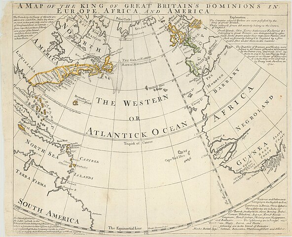
English: The map depicts the Atlantic basin, including the western portions of Europe and Africa, eastern North America, and the Caribbean. A combination of coloring and underlining are used to indicate British possessions, both present and “ancient.” Extensive notes in the spandrels provide details on territorial claims in Newfoundland, St. Helena, and Germany, as well as English “factories and settlements” in Asia. A comparison with old-color examples suggests that on this impression a modern colorist has erroneously added color to Cape Breton Island and Portugal. The map is undated, but has been assigned various dates of 1740 (American Antiquarian Society), 1752 (John Carter Brown), and even “1759-1763?” (Wisconsin Historical Society). The conservative coloring in North America, confining British territory east of the Appalachians, certainly allows us to date it to before the 1763 Treaty of Paris. It is also possible that the map could be more tightly dated by closer review of the Asian factories and settlements listed at lower right. |
| Date | Somewhere between 1740 and 1763 |
| Source | https://bostonraremaps.com/wp-content/uploads/2015/08/brm2067-bowen-kings-dominions-ca-1740-3000x2433.jpg |
| Author | Emanuel Bowen |
Licensing
[edit]
|
This work is in the public domain in its country of origin and other countries and areas where the copyright term is the author's life plus 70 years or fewer.
| |
| This file has been identified as being free of known restrictions under copyright law, including all related and neighboring rights. | |
This work is in the public domain in the United States because it was published (or registered with the U.S. Copyright Office) before January 1, 1929.
Public domain works must be out of copyright in both the United States and in the source country of the work in order to be hosted on the Commons. If the work is not a U.S. work, the file must have an additional copyright tag indicating the copyright status in the source country.
Note: This tag should not be used for sound recordings. |
File history
Click on a date/time to view the file as it appeared at that time.
| Date/Time | Thumbnail | Dimensions | User | Comment | |
|---|---|---|---|---|---|
| current | 18:39, 14 September 2022 | | 3,000 × 2,433 (1.58 MB) | Universalis (talk | contribs) | Uploaded a work by Emanuel Bowen from https://bostonraremaps.com/wp-content/uploads/2015/08/brm2067-bowen-kings-dominions-ca-1740-3000x2433.jpg with UploadWizard |
You cannot overwrite this file.
File usage on Commons
There are no pages that use this file.