File:A new map of Virginia, Maryland, and the improved parts of Pennsylvania & New Jersey. LOC 2005630923 (cropped).jpg
Jump to navigation
Jump to search
Size of this preview: 683 × 600 pixels. Other resolutions: 273 × 240 pixels | 547 × 480 pixels | 875 × 768 pixels | 1,167 × 1,024 pixels | 2,333 × 2,048 pixels | 6,709 × 5,889 pixels.
Original file (6,709 × 5,889 pixels, file size: 6.75 MB, MIME type: image/jpeg)
Captions
Captions
Add a one-line explanation of what this file represents
Summary[edit]
| Description |
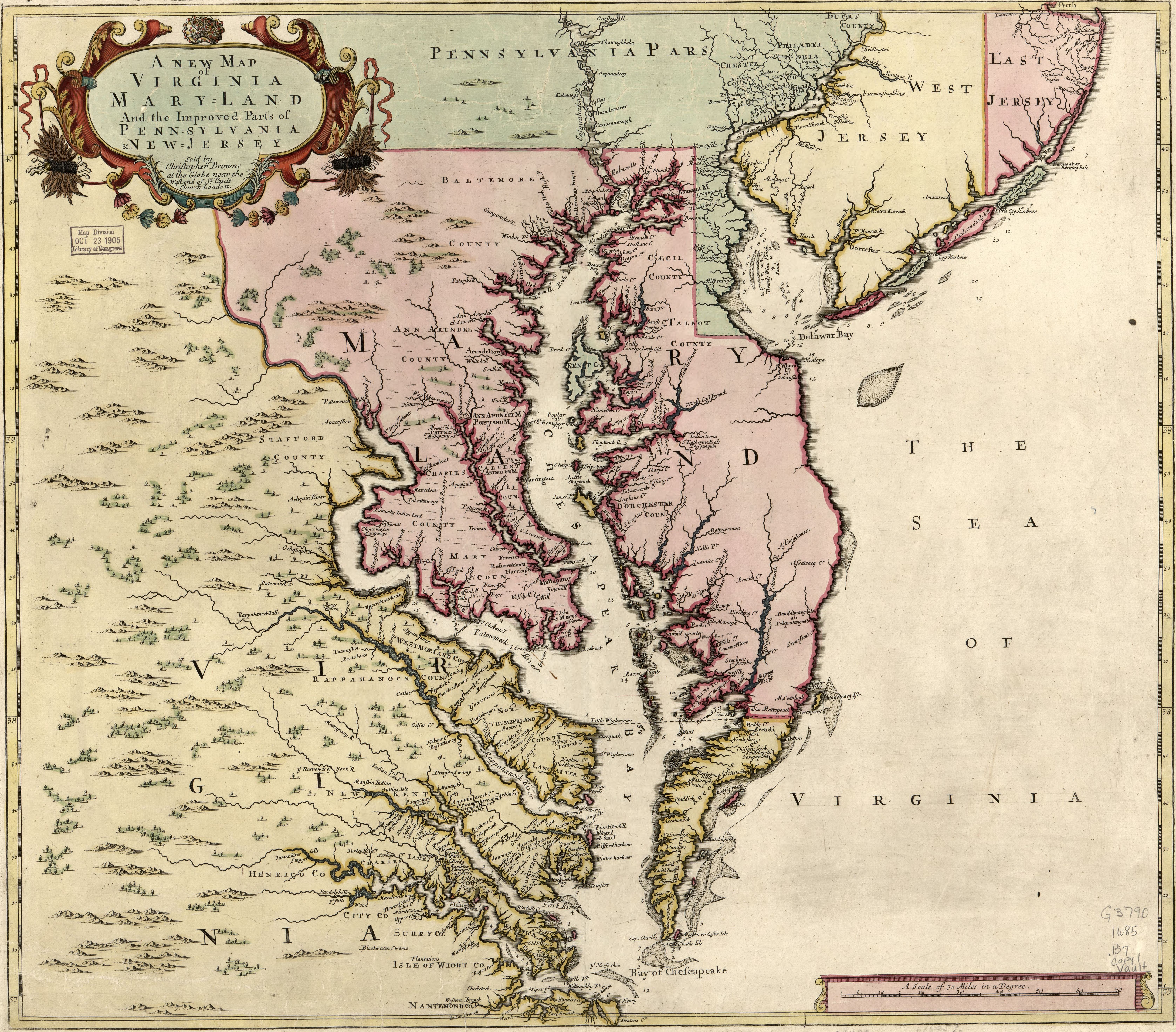
English: Relief shown pictorially. Depths shown by soundings. Date and attribution from On the Map, 1983 (Figure 24). First state of map published originally in 1685 by Christopher Browne with the imprint in the cartouche under the title. No longitude lines are given. Available also through the Library of Congress Web site as a raster image. LC copy annotated with pencil in bottom margin. Stamped and annotated in blue ink on verso: 24. LC copy imperfect: Loose binding along bottom margin. |
||
| Title | A new map of Virginia, Maryland, and the improved parts of Pennsylvania & New Jersey |
||
| Shelf ID | G3790 1685 .B7 | ||
| Date | |||
| Source | https://www.loc.gov/item/2005630923/ | ||
| Author | Browne, Christopher | ||
| Permission (Reusing this file) |
|
||
| Other versions |
|
||
| Location | Pennsylvania · Virginia · United States · New Jersey · Middle Atlantic States · Maryland | ||
| Part of | American Memory · General Maps · Catalog · Geography And Map Division | ||
| Subject | Pennsylvania · Virginia · New Jersey · United States · Maps · Early Works To 1800 · Middle Atlantic States · Maryland |

_in_A_new_map_of_Virginia,_Maryland,_and_the_improved_parts_of_Pennsylvania_%26_New_Jersey._LOC_2005630923_(cropped)_(cropped).jpg)

.jpg)
.jpg&action=edit§ion=1)
Licensing[edit]
.jpg&action=edit§ion=2)
|
This is a faithful photographic reproduction of a two-dimensional, public domain work of art. The work of art itself is in the public domain for the following reason:
The official position taken by the Wikimedia Foundation is that "faithful reproductions of two-dimensional public domain works of art are public domain".
This photographic reproduction is therefore also considered to be in the public domain in the United States. In other jurisdictions, re-use of this content may be restricted; see Reuse of PD-Art photographs for details. | ||||
File history
Click on a date/time to view the file as it appeared at that time.
| Date/Time | Thumbnail | Dimensions | User | Comment | |
|---|---|---|---|---|---|
| current | 17:33, 15 August 2019 | | 6,709 × 5,889 (6.75 MB) | Zeete (talk | contribs) | File:A new map of Virginia, Maryland, and the improved parts of Pennsylvania & New Jersey. LOC 2005630923.jpg cropped 3 % horizontally, 4 % vertically using CropTool with precise mode. |
You cannot overwrite this file.
File usage on Commons
The following 5 pages use this file:
- File:A new map of Virginia, Maryland, and the improved parts of Pennsylvania & New Jersey. LOC 2005630923.jpg
- File:A new map of Virginia, Maryland and the improved parts of Pennsylvania & New Jersey. LOC 2007625604 (cropped).jpg
- File:Cartouche in a Virginia by Senex.jpg
- File:The lower Potomac (Patowmeck) in A new map of Virginia, Maryland, and the improved parts of Pennsylvania & New Jersey. LOC 2005630923 (cropped) (cropped).jpg
- Category:A new map of Virginia, Maryland, and the improved parts of Pennsylvania & New Jersey by Christopher Browne
File usage on other wikis
The following other wikis use this file:
- Usage on ast.wikipedia.org
- Usage on en.wikipedia.org
- Usage on mt.wikipedia.org
- Usage on ru.wikipedia.org
- Usage on uk.wikipedia.org
- Usage on www.wikidata.org
.jpg&oldid=778613817)