File:A portion of Fort Leaton, a Texas State Historic Site, on the edge of Presidio, along the Rio Grande River in Brewster County, Texas LCCN2014630294.tif
Zur Navigation springen
Zur Suche springen

Größe der JPG-Vorschau dieser TIF-Datei: 800 × 534 Pixel. Weitere Auflösungen: 320 × 214 Pixel | 640 × 427 Pixel | 1.024 × 683 Pixel | 1.280 × 854 Pixel | 2.560 × 1.709 Pixel | 7.360 × 4.912 Pixel.
Originaldatei (7.360 × 4.912 Pixel, Dateigröße: 206,9 MB, MIME-Typ: image/tiff)
Bildtexte
Kurzbeschreibungen
Ergänze eine einzeilige Erklärung, was diese Datei darstellt.
Beschreibung[Bearbeiten]
| Beschreibung |
English: Title: A portion of Fort Leaton, a Texas State Historic Site, on the edge of Presidio, along the Rio Grande River in Brewster County, Texas
Physical description: 1 photograph : digital, tiff file, color. Notes: Title, date, and keywords based on information provided by the photographer.; Gift; The Lyda Hill Foundation; 2014; (DLC/PP-2014:054).; The adobe structure, which now serves as the western-side visitor center for BIg Bend Ranch State Park, was built in the 1830s and purchased by a prominent Anglo-American landholder, Ben Leaton, who expanded it into fortress dimensions and made it his home. What came to be called "Fort Leaton," though, contrary to erroneous local lore, it was never a Spanish fortification, was also Presidio County's first seat of government.; Forms part of: Lyda Hill Texas Collection of Photographs in Carol M. Highsmith's America Project in the Carol M. Highsmith Archive.; Credit line: The Lyda Hill Texas Collection of Photographs in Carol M. Highsmith's America Project, Library of Congress, Prints and Photographs Division. |
||||||||||||||||||||||||||
| Datum | Aufgenommen am 17. März 2014, 17:53 (gemäß Exif-Daten) | ||||||||||||||||||||||||||
| Quelle |
Library of Congress
|
||||||||||||||||||||||||||
| Urheber |
|
||||||||||||||||||||||||||
| Genehmigung (Weiternutzung dieser Datei) |
No known restrictions on publication.
|
||||||||||||||||||||||||||


| Kameraposition | | Dieses und weitere Bilder auf OpenStreetMap |
|---|
Lizenz[Bearbeiten]
| Dieses Werk stammt aus der Carol M. Highsmith Archive-Sammlung der Library of Congress. Laut der Bibliothek gibt es keine bekannten Copyright-Einschränkungen in der Verwendung dieses Werkes. Carol M. Highsmith has stipulated that her photographs are in the public domain. Photographs of sculpture or other works of art may be restricted by the copyright of the artist. |
 |
Dateiversionen
Klicke auf einen Zeitpunkt, um diese Version zu laden.
| Version vom | Vorschaubild | Maße | Benutzer | Kommentar | |
|---|---|---|---|---|---|
| aktuell | 16:32, 5. Sep. 2016 |  | 7.360 × 4.912 (206,9 MB) | Fæ (Diskussion | Beiträge) | LOC 2014630294, Carol M. Highsmith collection. P41.10360 TIFF (206.9mb) |
| 16:32, 5. Sep. 2016 | 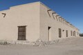 | 7.360 × 4.912 (206,9 MB) | Fæ (Diskussion | Beiträge) | LOC 2014630294, Carol M. Highsmith collection. P41.10360 TIFF (206.9mb) |
Du kannst diese Datei nicht überschreiben.
Dateiverwendung
Die folgende Seite verwendet diese Datei:
Globale Dateiverwendung
Die nachfolgenden anderen Wikis verwenden diese Datei:
- Verwendung auf ceb.wikipedia.org
- Verwendung auf de.wikipedia.org
- Verwendung auf en.wikipedia.org
- Verwendung auf en.wikivoyage.org
- Verwendung auf fr.wikipedia.org
- Verwendung auf www.wikidata.org