File:A sonda MOR e a acao de seus instrumentos.jpg

原始檔案 (4,000 × 2,944 像素,檔案大小:832 KB,MIME 類型:image/jpeg)
說明
說明
摘要
[編輯]
| 描述 |
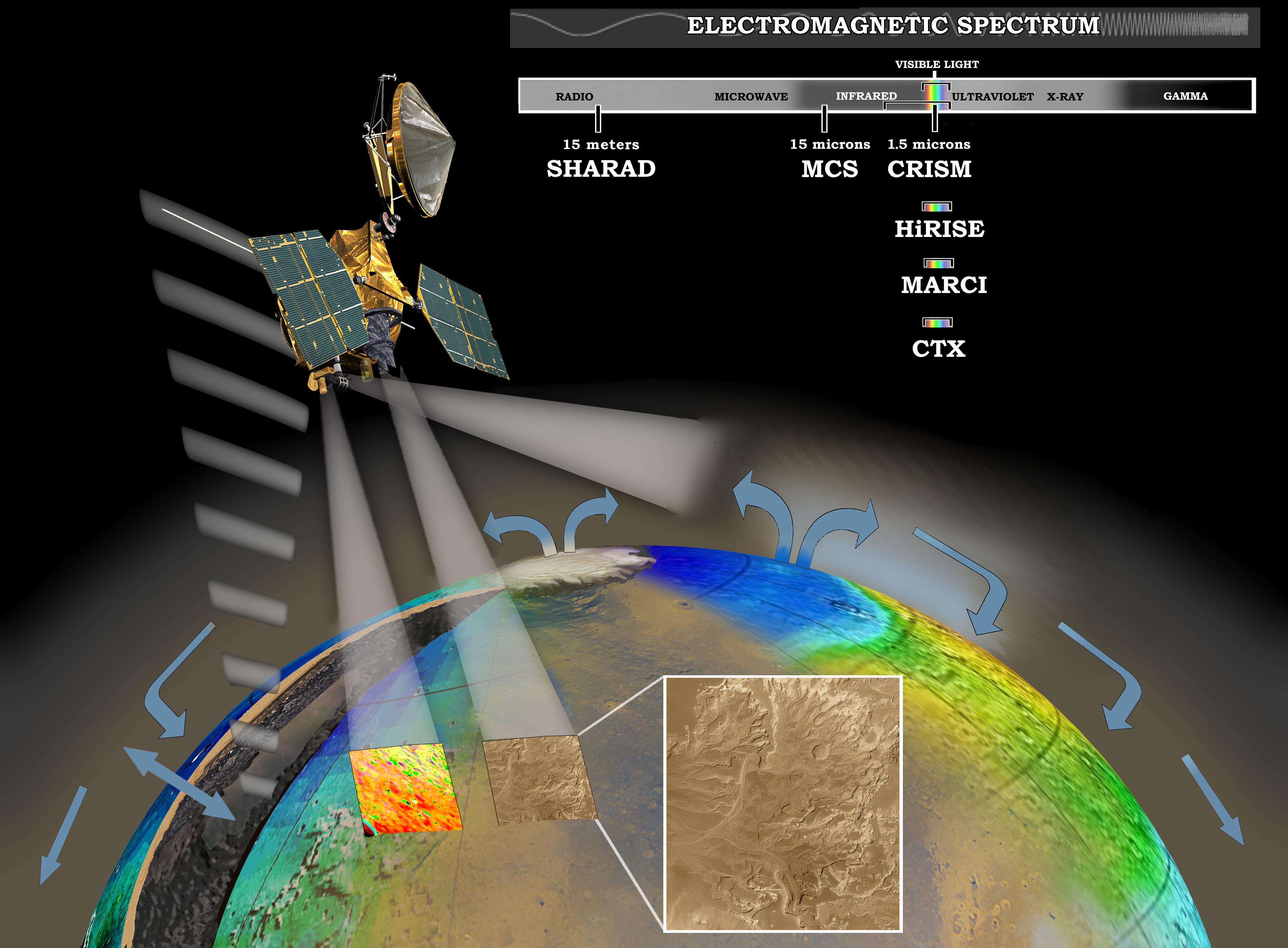
English: MRO investigating Martian water cycle - This artist's concept represents the "Follow the Water" theme of NASA's Mars Reconnaissance Orbiter mission. The orbiter's science instruments monitor the present water cycle in the Mars atmosphere and the associated deposition and sublimation of water ice on the surface, while probing the subsurface to see how deep the water-ice reservoir detected by Mars Odyssey extends. At the same time, Mars Reconnaissance Orbiter will search for surface features and minerals (such as carbonates and sulfates) that record the extended presence of liquid water on the surface earlier in the planet's history. The instruments involved are the Shallow Subsurface Radar, the Compact Reconnaissance Imaging Spectrometer for Mars, the Mars Color Imager, the High Resolution Imaging Science Experiment, the Context Camera and the Mars Climate Sounder.
To the far left, the radar antenna beams down and "sees" into the first few hundred feet (up to 1 kilometer) of Mars' crust. Just to the right of that, the next beam highlights the data received from the imaging spectrometer, which identifies minerals on the surface. The next beam represents the high-resolution camera, which can "zoom in" on local targets, providing the highest-resolution orbital images yet of features such as craters and gullies and rocks. The beam that shines almost horizontally is that of the Mars Climate Sounder. This instrument is critical to analyzing the current climate of Mars since it observes the temperature, humidity, and dust content of the martian atmosphere, and their seasonal and year-to-year variations. Meanwhile, the Mars Color Imager observes ice clouds, dust clouds and hazes, and the ozone distribution, producing daily global maps in multiple colors to monitor daily weather and seasonal changes. The electromagnetic spectrum is represented on the top right and individual instruments are placed where their capability lies.Русский: Шкала работы приборов MRO в электромагнитном спектре частот. |
| 日期 | |
| 來源 | http://photojournal.jpl.nasa.gov/catalog/PIA07241 (image link) |
| 作者 | NASA/JPL/Corby Waste |
| 此標籤不表示文件的著作權狀態。任何文件在附有此標籤的同時還需要一個有效的著作權標籤。請參閱許可協議說明頁面以了解更多資訊。 其他語言:
|
授權條款
[編輯]
| 本作品由NASA創作,屬於公有領域。根據NASA的版權政策:“NASA的創作除非另有聲明否則不受版權保護。”(參見:Template:PD-USGov/zh,NASA版權政策或JPL圖像使用政策) | ||
 |
警告:
|
檔案歷史
點選日期/時間以檢視該時間的檔案版本。
| 日期/時間 | 縮圖 | 尺寸 | 用戶 | 備註 | |
|---|---|---|---|---|---|
| 目前 | 2014年2月16日 (日) 20:38 | | 4,000 × 2,944(832 KB) | Huntster(對話 | 貢獻) | Updated version of image. SHARAD operates at 15 meters, not 15 cm. |
| 2005年10月16日 (日) 22:26 |  | 4,000 × 2,944(829 KB) | OS2Warp(對話 | 貢獻) | Artist's rendering of a Mars Reconnaissance Orbiter. Image by National Aeonautics and Space Asministration Source: http://photojournal.jpl.nasa.gov/ category:Mars (planet) Category:Mars Reconnaissance Orbiter category:Computer graphics [[p |
無法覆蓋此檔案。
檔案用途
沒有使用此檔案的頁面。
全域檔案使用狀況
以下其他 wiki 使用了這個檔案:
- ar.wikipedia.org 的使用狀況
- de.wikipedia.org 的使用狀況
- es.wikipedia.org 的使用狀況
- fi.wikipedia.org 的使用狀況
- he.wikipedia.org 的使用狀況
- id.wikipedia.org 的使用狀況
- it.wikipedia.org 的使用狀況
- ja.wikipedia.org 的使用狀況
- lb.wikipedia.org 的使用狀況
- no.wikipedia.org 的使用狀況
- pt.wikipedia.org 的使用狀況
- ro.wikipedia.org 的使用狀況
- ru.wikipedia.org 的使用狀況
- sh.wikipedia.org 的使用狀況
- sr.wikipedia.org 的使用狀況
- www.wikidata.org 的使用狀況
- zh.wikipedia.org 的使用狀況