File:Adashino Nenbutsu-ji - Flickr - mendhak.jpg
Jump to navigation
Jump to search

Size of this preview: 800 × 532 pixels. Other resolutions: 320 × 213 pixels | 640 × 425 pixels | 1,024 × 680 pixels | 1,280 × 851 pixels | 2,560 × 1,701 pixels | 6,000 × 3,987 pixels.
Original file (6,000 × 3,987 pixels, file size: 23.72 MB, MIME type: image/jpeg)
Captions
Captions
Add a one-line explanation of what this file represents
Summary
[edit]
| Description |
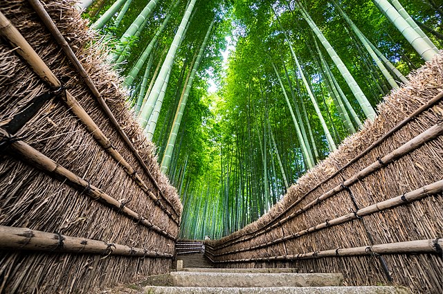
The bamboo path photo is a popular one and indeed this is what we did on the first day. It's known as the Arashiyama Bamboo Grove. What's not known is that there are two places to take the 'bamboo shot' from. The first is Arashiyama itself, but it's usually crowded and you have to be patient to get a solitary shot. The other is further along the trail, about 30 minutes walking at the Adashino Nenbutsu-ji temple. Towards the back are a set of stairs where you can take your time with these photos. |
| Date | Taken on 31 October 2016, 01:42 |
| Source | Adashino Nenbutsu-ji |
| Author | mendhak |
| Flickr tags | adashino nenbutsu-ji, sel1018, sony 10-18 mm f/4-5.6, a6300, arashiyama, bamboo, forest, kyoto, private, 化野念仏寺, 嵐山, kyōto-shi, kyōto-fu, japan, exif:lens=e 10-18mm f4 oss, camera:make=sony, geo:city=kyōto-shi, exif:make=sony, geo:country=japan, exif:model=ilce-6300, geo:state=kyōto-fu, exif:aperture=ƒ / 5.6, camera:model=ilce-6300, geo:lon=135.664501, exif:focal_length=10 mm, geo:location=トロッコ嵯峨駅, exif:iso_speed=400, geo:lat=35.0266266, wallpaper, mendhakwallpaper |
| Camera location | | View this and other nearby images on: OpenStreetMap |
|---|
Licensing
[edit]
This file is licensed under the Creative Commons Attribution-Share Alike 2.0 Generic license.
- You are free:
- to share – to copy, distribute and transmit the work
- to remix – to adapt the work
- Under the following conditions:
- attribution – You must give appropriate credit, provide a link to the license, and indicate if changes were made. You may do so in any reasonable manner, but not in any way that suggests the licensor endorses you or your use.
- share alike – If you remix, transform, or build upon the material, you must distribute your contributions under the same or compatible license as the original.
| This image was originally posted to Flickr by mendhak at https://flickr.com/photos/69135870@N00/30950626024. It was reviewed on 7 August 2020 by FlickreviewR 2 and was confirmed to be licensed under the terms of the cc-by-sa-2.0. |
File history
Click on a date/time to view the file as it appeared at that time.
| Date/Time | Thumbnail | Dimensions | User | Comment | |
|---|---|---|---|---|---|
| current | 00:35, 7 August 2020 | | 6,000 × 3,987 (23.72 MB) | Red panda bot (talk | contribs) | In Flickr Explore: 2016-12-21 |
You cannot overwrite this file.
File usage on Commons
There are no pages that use this file.
File usage on other wikis
The following other wikis use this file:
- Usage on es.wikipedia.org