File:Aerial View - Landschaft Markgräflerland1.jpg

原始檔案 (3,252 × 2,154 像素,檔案大小:6.77 MB,MIME 類型:image/jpeg)
說明
說明
摘要
[編輯]
| 描述 |
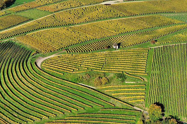
English: Aerial view of vineyards at Markgräflerland
Deutsch: Luftbild einer Weinbergfläche im Markgräflerland |
||
| 日期 | 攝於2012年十月21日 | ||
| 來源 | 自己的作品 | ||
| 作者 | Taxiarchos228 | ||
| 授權許可 (重用此檔案) |
|
||
| 其他版本 | Derivative works of this file: Aerial View - Landschaft Markgräflerland (crop).jpg |
.jpg)
| 目標地點 | | 位於此地的本圖片與其他圖片: OpenStreetMap |
|---|
評價
[編輯]
|
This image was selected as picture of the day on Wikimedia Commons for 10 February 2014. It was captioned as follows: English: Aerial view of vineyards at Markgräflerland Other languages:
Bosanski: Panoramski pogled na vinograde u oblasti Markgräflerland, Baden-Württemberg Deutsch: Luftbild einer Weinbergfläche im Markgräflerland English: Aerial view of vineyards at Markgräflerland Magyar: Markgräflerlandi szőlőültetvények légifelvételen (Németország, Baden-Württemberg) Nederlands: Luchtfoto van de wijngaarden van Markgräflerland, een streek in het zuidwesten van Duitsland in de deelstaat Baden-Württemberg. 中文: 鸟瞰德国马克格雷夫莱兰德的葡萄园。 |
授權條款
[編輯]

|
已授權您依據自由軟體基金會發行的無固定段落、封面文字和封底文字GNU自由文件授權條款1.2版或任意後續版本,對本檔進行複製、傳播和/或修改。該協議的副本列在GNU自由文件授權條款中。 |
- 您可以自由:
- 分享 – 複製、發佈和傳播本作品
- 重新修改 – 創作演繹作品
- 惟需遵照下列條件:
- 姓名標示 – 您必須指名出正確的製作者,和提供授權條款的連結,以及表示是否有對內容上做出變更。您可以用任何合理的方式來行動,但不得以任何方式表明授權條款是對您許可或是由您所使用。
 Bilder des zentralen Medienarchivs Wikimedia Commons, unterstehen einer Freien Lizenz. Diese Freiheit bedeutet nicht, dass dadurch das Urheberrecht entfällt. Ganz im Gegenteil: Als Gegenleistung für die kostenlose (nichtgewerbliche) Nutzung muss der Weiternutzer nur die Lizenzbedingungen einhalten und den Fotografen (meinen vollständigen Klarnamen Wladyslaw Sojka sowie die verlinkte Website www.sojka.photo) als Urheber nennen. Juristisch ist die unterlassene Namensnennung eine Urheberrechtsverletzung bzw. eine Verletzung der Urheberpersönlichkeitsrechte. Als Urheber kann ich mich gegen Bilderklau wehren, in dem ich einen Strafantrag stelle oder unmittelbar einen Rechtsanwalt beauftrage. Die Folge ist eine Abmahnung und die Aufforderung, eine strafbewehrte Unterlassungserklärung abzugeben. So weit sollte es nicht kommen. Bitte achten Sie auf diese Regeln oder kontaktieren Sie mich im Zweifelsfall. Sollten Abweichungen von den hier angegebenen Regeln erwünscht sein, dann bedarf es auf jeden Fall einer ausdrücklichen Genehmigung von mir als Urheber des jeweiligen Bildes. Kontaktmöglichkeiten: über Wikimedia Commons oder über www.sojka.photo. |
檔案歷史
點選日期/時間以檢視該時間的檔案版本。
| 日期/時間 | 縮圖 | 尺寸 | 用戶 | 備註 | |
|---|---|---|---|---|---|
| 目前 | 2012年11月5日 (一) 05:53 | | 3,252 × 2,154(6.77 MB) | Taxiarchos228(對話 | 貢獻) | {{Information |Description ={{en|1=Aerial view of vineyards at Markgräflerland}} {{de|1=Luftbild vom von einer Weinbergregion im Markgräflerland}} |Source ={{own}} |Author =Taxiarchos228 |Date =2012... |
無法覆蓋此檔案。
檔案用途
下列35個頁面有用到此檔案:
- Landscape
- User:Taxiarchos228/Pics/Germany
- User:Taxiarchos228/QICpromoted/Part 4
- User:Taxiarchos228/featured picture
- User:Ö/Best/2012
- Commons:Featured picture candidates/File:Aerial View - Landschaft Markgräflerland1.jpg
- Commons:Featured picture candidates/Log/November 2012
- Commons:Featured pictures/Places/Agriculture
- Commons:Featured pictures/chronological/2012-B
- Commons:Files used on the OpenStreetMap Wiki/2
- Commons:Picture of the Year/2012/Galleries/2012-B
- Commons:Picture of the Year/2012/Galleries/ALL
- Commons:Picture of the Year/2012/Galleries/Index/16
- Commons:Picture of the Year/2012/Galleries/NOV
- Commons:Picture of the Year/2012/Galleries/Nature views
- Commons:Picture of the Year/2012/R1/Aerial View - Landschaft Markgräflerland1.jpg
- Commons:Picture of the Year/2012/Results/R1/ALL
- Commons:Picture of the Year/2012/Results/R1/ALL/gallery
- Commons:Picture of the Year/2012/Results/R1/ALL/thumbnailtable
- Commons:Picture of the Year/2012/Results/R1/Nature views
- Commons:Quality images/Subject/Places/Mixed/Archive2
- Commons:Quality images candidates/Archives November 2012
- File:Aerial View - Landschaft Markgräflerland (crop).jpg
- Template:Potd/2014-02
- Template:Potd/2014-02-10
- Template:Potd/2014-02-10 (bs)
- Template:Potd/2014-02-10 (cs)
- Template:Potd/2014-02-10 (de)
- Template:Potd/2014-02-10 (en)
- Template:Potd/2014-02-10 (hu)
- Template:Potd/2014-02-10 (it)
- Template:Potd/2014-02-10 (nl)
- Template:Potd/2014-02-10 (ru)
- Template:Potd/2014-02-10 (zh-hans)
- Template:Potd/2014-02 (zh-hans)
全域檔案使用狀況
以下其他 wiki 使用了這個檔案:
- ar.wikipedia.org 的使用狀況
- be-tarask.wikipedia.org 的使用狀況
- bn.wikipedia.org 的使用狀況
- crh.wikipedia.org 的使用狀況
- cv.wikipedia.org 的使用狀況
- de.wikipedia.org 的使用狀況
- diq.wiktionary.org 的使用狀況
- dsb.wikipedia.org 的使用狀況
- en.wikipedia.org 的使用狀況
- en.wikivoyage.org 的使用狀況
- fa.wikipedia.org 的使用狀況
- fa.wikivoyage.org 的使用狀況
- fr.wikipedia.org 的使用狀況
- fr.wikiquote.org 的使用狀況
- fy.wikipedia.org 的使用狀況
- gom.wikipedia.org 的使用狀況
- hi.wikipedia.org 的使用狀況
- hsb.wikipedia.org 的使用狀況
- hu.wikipedia.org 的使用狀況
- id.wikipedia.org 的使用狀況
- incubator.wikimedia.org 的使用狀況
- it.wikipedia.org 的使用狀況
- ka.wikipedia.org 的使用狀況
- ko.wikipedia.org 的使用狀況
- krc.wikipedia.org 的使用狀況
- lbe.wikipedia.org 的使用狀況
- lb.wikipedia.org 的使用狀況
- nl.wikipedia.org 的使用狀況
- os.wikipedia.org 的使用狀況
- pl.wikipedia.org 的使用狀況
- pt.wikipedia.org 的使用狀況
- ru.wikipedia.org 的使用狀況
- ru.wikinews.org 的使用狀況
檢視此檔案的更多全域使用狀況。