File:Aerial photo of Hirizo Beach coastal area taken on August 11, 2013.jpg
Jump to navigation
Jump to search

Size of this preview: 480 × 600 pixels. Other resolutions: 192 × 240 pixels | 384 × 480 pixels | 614 × 768 pixels | 819 × 1,024 pixels | 2,363 × 2,953 pixels.
Original file (2,363 × 2,953 pixels, file size: 6.22 MB, MIME type: image/jpeg)
Captions
Captions
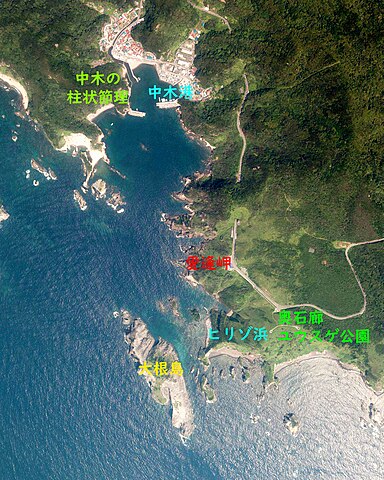
Aerial photo of Hirizo Beach coastal area taken on August 11, 2013.
Summary
[edit]
| Description |
日本語: ヒリゾ浜と周辺沿岸の空中写真(静岡県賀茂郡南伊豆町)CCB20133-C9-8を使用作成。
English: Aerial photo of Hirizo Beach coastal area taken on August 11, 2013. |
| Date | |
| Source | 国土情報ウェブマッピングシステム |
| Author | 国土地理院 |
Licensing
[edit]

|
The copyright holder of this file, the Ministry of Land, Infrastructure, Transport and Tourism of Japan, allows anyone to use it for any purpose, provided that the copyright holder is properly attributed. Redistribution, derivative work, commercial use, and all other use is permitted. |
Attribution:
Copyright © National Land Image Information (Color Aerial Photographs), Ministry of Land, Infrastructure, Transport and Tourism
|
 |
This image is copyrighted by the Ministry of Land, Infrastructure, Transport and Tourism of Japan. For terms of use, see the stipulation to use of National Land Information (in Japanese) and message from MLIT (in Japanese and English). When you display this image on an article, include the following phrase in the description: "Made based on National Land Image Information (Color Aerial Photographs), Ministry of Land, Infrastructure, Transport and Tourism".
|
File history
Click on a date/time to view the file as it appeared at that time.
| Date/Time | Thumbnail | Dimensions | User | Comment | |
|---|---|---|---|---|---|
| current | 05:37, 4 January 2024 | | 2,363 × 2,953 (6.22 MB) | さかおり (talk | contribs) | Add place name |
| 06:06, 17 October 2023 |  | 2,387 × 2,984 (8.25 MB) | さかおり (talk | contribs) | Uploaded a work by 国土地理院 from 国土情報ウェブマッピングシステム with UploadWizard |
You cannot overwrite this file.
File usage on Commons
The following page uses this file:
File usage on other wikis
The following other wikis use this file: