File:Aerial view of the Goose Village neighbourhood (1947-1949).jpg
Jump to navigation
Jump to search

Size of this preview: 590 × 600 pixels. Other resolutions: 236 × 240 pixels | 472 × 480 pixels | 755 × 768 pixels | 1,007 × 1,024 pixels | 2,014 × 2,048 pixels | 3,246 × 3,300 pixels.
Original file (3,246 × 3,300 pixels, file size: 3.19 MB, MIME type: image/jpeg)
Captions
Captions
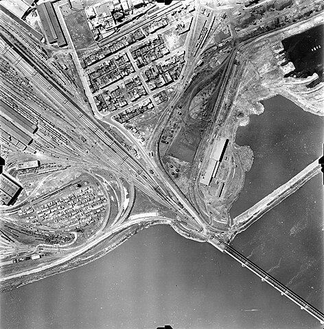
Aerial view of the Goose Village neighbourhood in Montreal, taken between 1947 and 1949 (Archives de la Ville de Montréal)
Summary
[edit].jpg&action=edit§ion=1)
| Description |
English: A black-and-white photograph showing an aerial view of a city. The lower half of the image is water and the upper half is land. A railroad cuts through the image diagonally. A small neighbourhood of buildings lies just above the railroad. |
| Date | |
| Source | https://archivesdemontreal.com/greffe/vues-aeriennes-archives/jpeg/VM97-3_7P4-22.jpg |
| Author | Archives de la Ville de Montréal |
| Camera location | | View this and other nearby images on: OpenStreetMap |
|---|
.jpg¶ms=045.486992_N_-073.545070_E_globe:Earth_type:camera__&language=en)
Licensing
[edit].jpg&action=edit§ion=2)
This file is licensed under the Creative Commons Attribution 4.0 International license.
- You are free:
- to share – to copy, distribute and transmit the work
- to remix – to adapt the work
- Under the following conditions:
- attribution – You must give appropriate credit, provide a link to the license, and indicate if changes were made. You may do so in any reasonable manner, but not in any way that suggests the licensor endorses you or your use.
File history
Click on a date/time to view the file as it appeared at that time.
| Date/Time | Thumbnail | Dimensions | User | Comment | |
|---|---|---|---|---|---|
| current | 01:09, 22 March 2023 | | 3,246 × 3,300 (3.19 MB) | RacingThoughts (talk | contribs) | Uploaded a work by Archives de la Ville de Montréal from https://archivesdemontreal.com/greffe/vues-aeriennes-archives/jpeg/VM97-3_7P4-22.jpg with UploadWizard |
You cannot overwrite this file.
File usage on Commons
There are no pages that use this file.
File usage on other wikis
The following other wikis use this file:
- Usage on en.wikipedia.org
.jpg&oldid=785730170)