File:Africa-regions.png
跳转到导航
跳转到搜索
没有更高的分辨率。
Africa-regions.png (360 × 392像素,文件大小:8 KB,MIME类型:image/png)
说明
说明
添加一行文字以描述该文件所表现的内容
摘要[编辑]
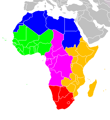
Africa: subregions as delineated by United Nations geographic classification scheme:
许可协议[编辑]
我,本作品著作权人,特此采用以下许可协议发表本作品:

|
已授权您依据自由软件基金会发行的无固定段落及封面封底文字(Invariant Sections, Front-Cover Texts, and Back-Cover Texts)的GNU自由文件许可协议1.2版或任意后续版本的条款,复制、传播和/或修改本文件。该协议的副本请见“GNU Free Documentation License”。 |
| 本文件采用知识共享署名-相同方式共享 3.0 未本地化版本许可协议授权。 | ||
| ||
| 本许可协议标签作为GFDL许可协议更新的组成部分被添加至本文件。 |
- 您可以自由地:
- 共享 – 复制、发行并传播本作品
- 修改 – 改编作品
- 惟须遵守下列条件:
- 署名 – 您必须对作品进行署名,提供授权条款的链接,并说明是否对原始内容进行了更改。您可以用任何合理的方式来署名,但不得以任何方式表明许可人认可您或您的使用。
- 相同方式共享 – 如果您再混合、转换或者基于本作品进行创作,您必须以与原先许可协议相同或相兼容的许可协议分发您贡献的作品。
您可以选择您需要的许可协议。

|
File:Africa map regions.svg是此文件的矢量版本。 如果此文件质量不低于原点阵图,就应该将这个PNG格式文件替换为此文件。
File:Africa-regions.png → File:Africa map regions.svg
更多信息请参阅Help:SVG/zh。 |
 |
文件历史
点击某个日期/时间查看对应时刻的文件。
| 日期/时间 | 缩略图 | 大小 | 用户 | 备注 | |
|---|---|---|---|---|---|
| 当前 | 2018年6月1日 (五) 02:02 | | 360 × 392(8 KB) | Vesperius(留言 | 贡献) | Reverted to version as of 18:36, 28 May 2018 (UTC) (Most definitions of the regions include the Horn of Africa as part of East Africa, so I'm reverting this back) |
| 2018年5月28日 (一) 18:37 |  | 360 × 392(10 KB) | Vesperius(留言 | 贡献) | Reverted to version as of 18:25, 28 May 2018 (UTC) (Messed up, the purple indicating the Horn of Africa didn't show up for me) | |
| 2018年5月28日 (一) 18:36 |  | 360 × 392(8 KB) | Vesperius(留言 | 贡献) | Reverted to version as of 01:04, 16 May 2018 (UTC) | |
| 2018年5月28日 (一) 18:25 |  | 360 × 392(10 KB) | Vesperius(留言 | 贡献) | Reverted to version as of 18:57, 17 March 2018 (UTC) | |
| 2018年5月16日 (三) 01:04 |  | 360 × 392(8 KB) | Dwo(留言 | 贡献) | Reverted to version as of 08:22, 30 August 2015 (UTC) | |
| 2018年3月17日 (六) 18:57 |  | 360 × 392(10 KB) | Maphobbyist(留言 | 贡献) | Montenegro border | |
| 2015年8月30日 (日) 08:22 |  | 360 × 392(8 KB) | Wiki-Zyron(留言 | 贡献) | Reverted to version as of 00:23, 20 December 2012 - Reverted to the last version before someone inexplicably moved Zimbabwe to Southern Africa. Eastern Africa is the correct region - [http://unstats.un.org/unsd/methods/m49/m49regin.htm#africa] | |
| 2015年4月21日 (二) 05:04 |  | 360 × 392(16 KB) | TAKASUGI Shinji(留言 | 贡献) | Corrected the color of Zimbabwe | |
| 2014年12月18日 (四) 15:16 |  | 360 × 392(17 KB) | Hybscher(留言 | 贡献) | wrong colors | |
| 2014年11月22日 (六) 22:39 |  | 2,000 × 2,050(342 KB) | Andrew J.Kurbiko(留言 | 贡献) | pp |
您不可以覆盖此文件。
文件用途
以下4个页面使用本文件:
全域文件用途
以下其他wiki使用此文件:
- af.wikipedia.org上的用途
- anp.wikipedia.org上的用途
- ar.wikipedia.org上的用途
- arz.wikipedia.org上的用途
- avk.wikipedia.org上的用途
- azb.wikipedia.org上的用途
- ba.wikipedia.org上的用途
- bg.wikipedia.org上的用途
- blk.wikipedia.org上的用途
- bn.wikipedia.org上的用途
- br.wikipedia.org上的用途
- bxr.wikipedia.org上的用途
- ca.wikipedia.org上的用途
- cy.wikipedia.org上的用途
- de.wikipedia.org上的用途
- el.wikipedia.org上的用途
- en.wikipedia.org上的用途
- Southern Africa
- Walvis Bay-Ndola-Lubumbashi Development Road
- N1 road (Gabon)
- User:R4000/Africa(Alt)
- Cairo Road
- User:ArminHammer
- User:Donbert/motherafrica
- User:Donbert/userboxes
- United Nations geoscheme
- United Nations geoscheme for Africa
- Rua Libertadores de África
- Lists of cities in Africa
- Portuguese Africans
- Sam Nujoma Street
- Cairo–Dakar Highway
- N'Djamena–Djibouti Highway
- Portal:Africa/Countries
查看本文件的更多全域用途。