File:Africa-regions.png
跳至導覽
跳至搜尋
無更高解析度可提供。
Africa-regions.png (360 × 392 像素,檔案大小:8 KB,MIME 類型:image/png)
說明
說明
添加單行說明來描述出檔案所代表的內容
摘要[編輯]
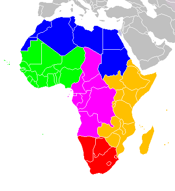
Africa: subregions as delineated by United Nations geographic classification scheme:
授權條款[編輯]
我,本作品的著作權持有者,決定用以下授權條款發佈本作品:

|
已授權您依據自由軟體基金會發行的無固定段落、封面文字和封底文字GNU自由文件授權條款1.2版或任意後續版本,對本檔進行複製、傳播和/或修改。該協議的副本列在GNU自由文件授權條款中。 |
| 此檔案採用創用CC 姓名標示-相同方式分享 3.0 未在地化版本授權條款。 | ||
| ||
| 已新增授權條款標題至此檔案,作為GFDL授權更新的一部份。 |
您可以選擇您需要的授權條款。

|
File:Africa-regions.svg是本檔案的向量版本。 如果品質不低,就應該優先使用該檔案,而非PNG檔案。
File:Africa-regions.png → File:Africa-regions.svg
更多資訊請參閱Help:SVG/zh。 |
 |
檔案歷史
點選日期/時間以檢視該時間的檔案版本。
| 日期/時間 | 縮圖 | 尺寸 | 使用者 | 備註 | |
|---|---|---|---|---|---|
| 目前 | 2018年6月1日 (五) 02:02 | | 360 × 392(8 KB) | Vesperius(留言 | 貢獻) | Reverted to version as of 18:36, 28 May 2018 (UTC) (Most definitions of the regions include the Horn of Africa as part of East Africa, so I'm reverting this back) |
| 2018年5月28日 (一) 18:37 |  | 360 × 392(10 KB) | Vesperius(留言 | 貢獻) | Reverted to version as of 18:25, 28 May 2018 (UTC) (Messed up, the purple indicating the Horn of Africa didn't show up for me) | |
| 2018年5月28日 (一) 18:36 |  | 360 × 392(8 KB) | Vesperius(留言 | 貢獻) | Reverted to version as of 01:04, 16 May 2018 (UTC) | |
| 2018年5月28日 (一) 18:25 |  | 360 × 392(10 KB) | Vesperius(留言 | 貢獻) | Reverted to version as of 18:57, 17 March 2018 (UTC) | |
| 2018年5月16日 (三) 01:04 |  | 360 × 392(8 KB) | Dwo(留言 | 貢獻) | Reverted to version as of 08:22, 30 August 2015 (UTC) | |
| 2018年3月17日 (六) 18:57 |  | 360 × 392(10 KB) | Maphobbyist(留言 | 貢獻) | Montenegro border | |
| 2015年8月30日 (日) 08:22 |  | 360 × 392(8 KB) | Wiki-Zyron(留言 | 貢獻) | Reverted to version as of 00:23, 20 December 2012 - Reverted to the last version before someone inexplicably moved Zimbabwe to Southern Africa. Eastern Africa is the correct region - [http://unstats.un.org/unsd/methods/m49/m49regin.htm#africa] | |
| 2015年4月21日 (二) 05:04 |  | 360 × 392(16 KB) | TAKASUGI Shinji(留言 | 貢獻) | Corrected the color of Zimbabwe | |
| 2014年12月18日 (四) 15:16 |  | 360 × 392(17 KB) | Hybscher(留言 | 貢獻) | wrong colors | |
| 2014年11月22日 (六) 22:39 |  | 2,000 × 2,050(342 KB) | Andrew J.Kurbiko(留言 | 貢獻) | pp |
無法覆蓋此檔案。
檔案用途
下列4個頁面有用到此檔案:
全域檔案使用狀況
以下其他 wiki 使用了這個檔案:
- anp.wikipedia.org 的使用狀況
- ar.wikipedia.org 的使用狀況
- arz.wikipedia.org 的使用狀況
- avk.wikipedia.org 的使用狀況
- azb.wikipedia.org 的使用狀況
- ba.wikipedia.org 的使用狀況
- bg.wikipedia.org 的使用狀況
- blk.wikipedia.org 的使用狀況
- bn.wikipedia.org 的使用狀況
- br.wikipedia.org 的使用狀況
- bxr.wikipedia.org 的使用狀況
- ca.wikipedia.org 的使用狀況
- de.wikipedia.org 的使用狀況
- el.wikipedia.org 的使用狀況
- en.wikipedia.org 的使用狀況
- Southern Africa
- Walvis Bay-Ndola-Lubumbashi Development Road
- N1 road (Gabon)
- User:R4000/Africa(Alt)
- Cairo Road
- User:ArminHammer
- User:Donbert/motherafrica
- User:Donbert/userboxes
- United Nations geoscheme
- United Nations geoscheme for Africa
- Rua Libertadores de África
- Lists of cities in Africa
- Portuguese Africans
- Sam Nujoma Street
- Cairo–Dakar Highway
- N'Djamena–Djibouti Highway
- Portal:Africa/Countries
- Portal:Africa/Countries/Map
- B8 road (Namibia)
- Template:Africa-road-stub
檢視此檔案的更多全域使用狀況。