File:Africa1898.png
原始檔案 (2,490 × 3,563 像素,檔案大小:4.14 MB,MIME 類型:image/png)
說明
說明
摘要[編輯]
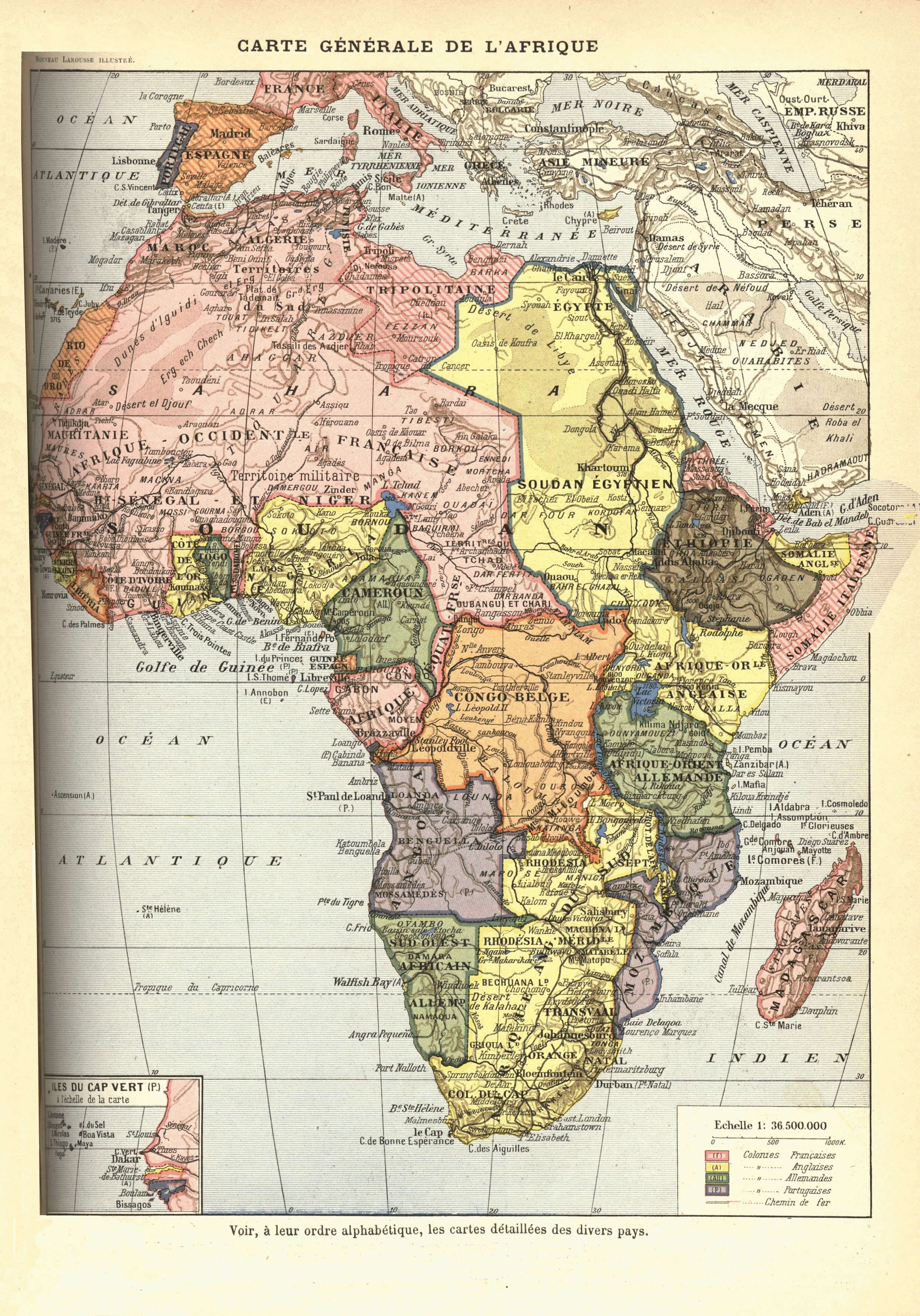
French map of Africa from 1912? [text in comment below says 1898], originally published as "Carte Générale de l'Afrique : Voir, à leur ordre alphabétique, les cartes detaillées des divers pays" in Nouveau Larousse illustré ; dictionnaire universel encyclopédique, publié sous la direction de Claude Augé. Paris, Librairie Larousse. 1898-1904. Original scan available at http://www.lib.msu.edu/coll/main/maps/mapscan/AFthumbs.html
Colonial claims:
- British possessions are in yellow
- French possessions in pink
- Belgian in orange
- German in green
- Portuguese in purple
- Italian in striped pink
- Spanish in striped orange
- independent Ethiopia in brown
Note:
This map is depicts various anachronisms and despite the stated publication date above (different editions?) of its work, was drawn between 1911 and 1914:
- en:Belgian Congo includes the en:Lado enclave, which was ceded to Anglo-Sudan in 1910.
- Occupation of Libya by Italy started in 1911, and the colony was established in 1912.
- "Cameroun" is depicted with the territory of German en:Neukamerun, ceded from France 1911.
授權條款[編輯]
|
本作品在其來源國以及其他版權期限是作者逝世後70年或以下的國家與地區屬於公有領域。
| |
| 此作品無已知的著作權限制,亦不受所有相關和鄰接的權利限制。 | |
檔案歷史
點選日期/時間以檢視該時間的檔案版本。
| 日期/時間 | 縮圖 | 尺寸 | 用戶 | 備註 | |
|---|---|---|---|---|---|
| 目前 | 2009年7月16日 (四) 16:27 | | 2,490 × 3,563(4.14 MB) | Jonverve~commonswiki(對話 | 貢獻) | update - rotate and fix |
| 2006年5月11日 (四) 19:49 |  | 962 × 1,314(915 KB) | Kmusser(對話 | 貢獻) | French map of Africa from 1898, originally published as "Carte Generale de l'Afrique: Voir, a leur orde alphabetique, les cartes detaillees des divers pays" in Nouveau Larousse illustré; dictionnaire universel encyclopédique, publié sous la direction d |
無法覆蓋此檔案。
檔案用途
下列頁面有用到此檔案:
全域檔案使用狀況
以下其他 wiki 使用了這個檔案:
- ast.wikipedia.org 的使用狀況
- az.wikipedia.org 的使用狀況
- ba.wikipedia.org 的使用狀況
- be.wikipedia.org 的使用狀況
- bg.wikipedia.org 的使用狀況
- da.wikipedia.org 的使用狀況
- en.wikiversity.org 的使用狀況
- es.wikipedia.org 的使用狀況
- fr.wikipedia.org 的使用狀況
- he.wikipedia.org 的使用狀況
- hu.wikipedia.org 的使用狀況
- hy.wikipedia.org 的使用狀況
- is.wikipedia.org 的使用狀況
- it.wikipedia.org 的使用狀況
- ja.wikipedia.org 的使用狀況
- mk.wikipedia.org 的使用狀況
- mwl.wikipedia.org 的使用狀況
- nl.wikipedia.org 的使用狀況
- oc.wikipedia.org 的使用狀況
- pl.wikipedia.org 的使用狀況
- pt.wikipedia.org 的使用狀況
- História da África
- História da Guiné-Bissau
- História da Libéria
- História da Nigéria
- História do Congo
- História de Burquina Fasso
- História de Moçambique
- História da Etiópia
- História do Gabão
- História da Líbia
- História de Marrocos
- História do Quênia
- História do Gana
- História da África do Sul
- História da Costa do Marfim
- História da Tunísia
- História do Sudão
- História do Ruanda
- História do Togo
- História de Cabo Verde
檢視此檔案的更多全域使用狀況。