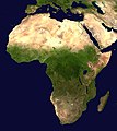
File:Africa satellite orthographic.jpg
來自Wikimedia Commons
跳去導覽
跳去搵嘢

預覽大細:534 × 600 像素。 第啲解像度:214 × 240 像素 | 427 × 480 像素 | 684 × 768 像素 | 912 × 1,024 像素 | 1,624 × 1,824 像素。
原本檔案 (1,624 × 1,824 像素,檔案大細:535 KB ,MIME類型:image/jpeg)
File information
Structured data
Captions
Captions
Add a one-line explanation of what this file represents
إفريقيا
taswirar yankunan Afirka
محمد
摘要[編輯]
| 描述Africa satellite orthographic.jpg |
English: A composed satellite photograph of Africa in orthographic projection. This is NASA "Blue Marble" image applied as a texture on a sphere using Art of Illusion program. The observer is centered at (0° N, 15° E), at Moon distance above the Earth.
العربية: خريطة جغرافية لأفريقيا توضح الانقطاع البيئي الذي يحدد منطقة الصحراء |
| 日期 |
未知日期 Unknown date |
| 來源 | NASA |
| 作者 | NASA |
協議[編輯]
| Public domainPublic domainfalsefalse |
| This file is in the public domain in the United States because it was solely created by NASA. NASA copyright policy states that "NASA material is not protected by copyright unless noted". (See Template:PD-USGov, NASA copyright policy page or JPL Image Use Policy.) |  | |
 |
Warnings:
|
檔案歷史
撳個日期/時間去睇響嗰個時間出現過嘅檔案。
| 日期/時間 | 縮圖 | 尺寸 | 用戶 | 註解 | |
|---|---|---|---|---|---|
| 現時 | 2005年4月19號 (二) 09:44 |  | 1,624 × 1,824(535 KB) | Ghalas(傾偈 | 貢獻) | A composed satellite photograph of Africa in orthographic projection This is NASA [http://visibleearth.nasa.gov/view_rec.php?vev1id=11656 "Blue Marble"] image applied as a texture on a sphere u |
你無得衾咗個檔案。
檔案用途
以下嘅6版用到呢個檔:
全域檔案使用情況
下面嘅維基都用緊呢個檔案:
- af.wikipedia.org嘅使用情況
- ang.wikipedia.org嘅使用情況
- ar.wikipedia.org嘅使用情況
- ar.wikinews.org嘅使用情況
- ary.wikipedia.org嘅使用情況
- arz.wikipedia.org嘅使用情況
- ast.wikipedia.org嘅使用情況
- as.wikipedia.org嘅使用情況
- awa.wikipedia.org嘅使用情況
- az.wikipedia.org嘅使用情況
- bat-smg.wikipedia.org嘅使用情況
- ba.wikipedia.org嘅使用情況
- be-tarask.wikipedia.org嘅使用情況
- be.wikipedia.org嘅使用情況
- bg.wikipedia.org嘅使用情況
睇呢個檔案嘅更多全域使用情況。
Metadata
呢個檔案有額外嘅資料。佢應該係數碼相機或者掃描器整出來嘅。如果佢整咗之後畀人改過,裏面嘅資料未必同改過之後相符。
| _error | 0 |
|---|