File:Airports between Bodø and Tromsø.svg
Jump to navigation
Jump to search

Size of this PNG preview of this SVG file: 512 × 557 pixels. Other resolutions: 221 × 240 pixels | 441 × 480 pixels | 706 × 768 pixels | 941 × 1,024 pixels | 1,883 × 2,048 pixels.
Original file (SVG file, nominally 512 × 557 pixels, file size: 344 KB)
Captions
Captions
Add a one-line explanation of what this file represents
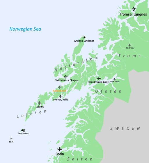
| Description | Airport between and included Bodø and Tromsø in Norway. Proposed airports in blue, existing airports in black. |
| Date | |
| Source | Own work |
| Author |
User:Arsenikk Derived from File:Norway municipalities 2010 blank.svg |
This file is licensed under the Creative Commons Attribution-Share Alike 2.0 Generic license.
- You are free:
- to share – to copy, distribute and transmit the work
- to remix – to adapt the work
- Under the following conditions:
- attribution – You must give appropriate credit, provide a link to the license, and indicate if changes were made. You may do so in any reasonable manner, but not in any way that suggests the licensor endorses you or your use.
- share alike – If you remix, transform, or build upon the material, you must distribute your contributions under the same or compatible license as the original.
File history
Click on a date/time to view the file as it appeared at that time.
| Date/Time | Thumbnail | Dimensions | User | Comment | |
|---|---|---|---|---|---|
| current | 21:29, 26 February 2017 | | 512 × 557 (344 KB) | Shandris (talk | contribs) | Better layout, removed Gimsøy as it is no longer part of the airport prospecting plan |
| 22:26, 27 February 2013 |  | 543 × 610 (531 KB) | Arsenikk (talk | contribs) | {{Information |Description=Airport between and included Bodø and Tromsø in Norway. Proposed airports in blue, existing airports in black. |Source={{Own work}} |Date=2013-02-27 |Author=User:Arsenikk<br>Derived from File:Norway municipalities 2010 ... |
You cannot overwrite this file.
File usage on Commons
The following 5 pages use this file:
- User:Chumwa/OgreBot/Potential transport maps/2017 February 19-28
- User:Chumwa/OgreBot/Transport Maps/2017 February 19-28
- User:Chumwa/OgreBot/Travel and communication maps/2017 February 19-28
- Commons:WikiProject Aviation/recent uploads/2013 February 21-28
- Commons:WikiProject Aviation/recent uploads/2017 February 26
File usage on other wikis
The following other wikis use this file:
- Usage on ast.wikipedia.org
- Usage on en.wikipedia.org
- Usage on es.wikipedia.org
- Usage on fr.wikipedia.org