File:Akecoregions.jpg
Jump to navigation
Jump to search
Size of this preview: 778 × 600 pixels. Other resolutions: 311 × 240 pixels | 623 × 480 pixels | 996 × 768 pixels | 1,270 × 979 pixels.
Original file (1,270 × 979 pixels, file size: 236 KB, MIME type: image/jpeg)
Captions
Captions
Add a one-line explanation of what this file represents
Summary
[edit]
| Description |
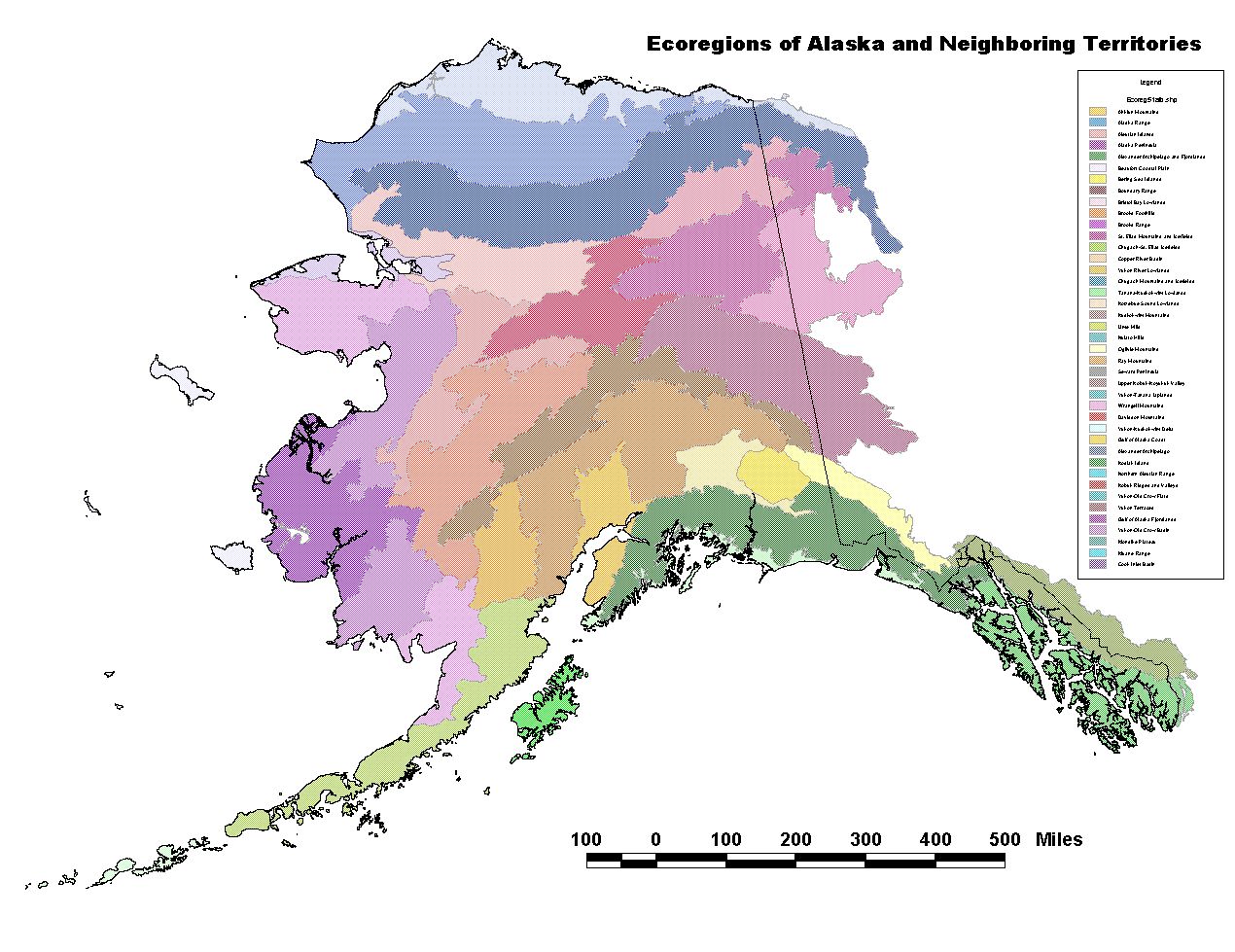
English: "Unified Ecoregions of Alaska: 2001. This ecoregion map combines the Bailey and Omernik approach to ecoregion mapping in Alaska. The ecoregions were developed cooperatively by the U.S. Forest Service, National Park Service, U.S. Geological Survey, The Nature Conservancy, and personnel from many other agencies and private organizations."
Quoted from source (Metadata): The Ecoregion units are arranged in two higher levels along
gradients of climate, vegetation and disturbance processes.
Thirty two ecoregions fit into eight groups at Level 2, and
three regimes at Level 1 (Boreal, Maritime and Polar).
Please refer to the tri-archy found on the back of the
published map. Written descriptions are located in the
section of Overview Description, following the individual
ecoregional descriptions.
Level 1 Level 2 Ecoregion
Polar (-like)
Arctic Tundra
Beaufort Coastal Plain
Brooks Foothills
Brooks Range
Bering Tundra
Kotzebue Sound Lowlands
Seward Peninsula
Bering Sea Islands
Boreal (-like)
Bering Taiga
Nulato Hills
Yukon-Kuskokwim Delta
Ahklun Mountains
Bristol Bay Lowlands
Intermontane Boreal
Kobuk Ridges and Valleys
Ray Mountains
Davidson Mountains
Yukon-Old Crow Basin
North Ogilvie Mountains
Yukon-Tanana Uplands
Tanana-Kuskokwim Lowlands
Yukon River Lowlands
Kuskokwim Mountains
Alaska Range Transition
Lime Hills
Alaska Range
Cook Inlet Basin
Copper River Basin
Maritime (-like)
Aleutian Meadows
Alaska Peninsula
Aleutian Islands
Coastal Rainforests
Alexander Archipelago
Boundary Ranges
Chugach-St. Elias Mountains
Gulf of Alaska Coast
Kodiak Island
Coast Mountains Transition
Wrangell Mountains
Kluane Range
end quote |
| Date | |
| Source | [1] Alaska Geospatial regions clearinghouse; Ecoregions of Alaska: 2001. U.S. Geological Survey Open-File Report 02-297 (map). |
| Author | Nowacki, Gregory; Spencer, Page; Fleming, Michael; Brock, Terry; and Jorgenson, Torre ; USGS and other agencies |
Licensing
[edit]
This work is in the public domain in the United States because it is a work prepared by an officer or employee of the United States Government as part of that person’s official duties under the terms of Title 17, Chapter 1, Section 105 of the US Code.
Note: This only applies to original works of the Federal Government and not to the work of any individual U.S. state, territory, commonwealth, county, municipality, or any other subdivision. This template also does not apply to postage stamp designs published by the United States Postal Service since 1978. (See § 313.6(C)(1) of Compendium of U.S. Copyright Office Practices). It also does not apply to certain US coins; see The US Mint Terms of Use.
|
 | |
| This file has been identified as being free of known restrictions under copyright law, including all related and neighboring rights. | ||
File history
Click on a date/time to view the file as it appeared at that time.
| Date/Time | Thumbnail | Dimensions | User | Comment | |
|---|---|---|---|---|---|
| current | 15:05, 27 July 2012 | | 1,270 × 979 (236 KB) | Dankarl (talk | contribs) |
You cannot overwrite this file.
File usage on Commons
There are no pages that use this file.
File usage on other wikis
The following other wikis use this file:
- Usage on de.wikipedia.org