File:Alabama Congressional Districts, 113th Congress.tif
跳至導覽
跳至搜尋

此 TIF 檔案的 JPG 預覽的大小:390 × 599 像素。 其他解析度:156 × 240 像素 | 620 × 952 像素。
原始檔案 (620 × 952 像素,檔案大小:215 KB,MIME 類型:image/tiff)
說明
說明
添加單行說明來描述出檔案所代表的內容
摘要
[編輯]| 描述 |
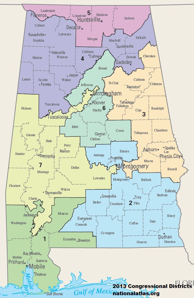
English: Map of Congressional Districts in the state of Alabama, reflecting district boundaries current to the 113th United States Congress. |
| 日期 | |
| 來源 | National Atlas of the United States |
| 作者 | Department of the Interior |
授權條款
[編輯]本地圖取自美國國家地圖集的某個版本。國家地圖集的絕大多數作品是美國聯邦政府的作品,因此屬於公有領域。
連結網址︰ NationalAtlas.gov | 1970年印刷版︰ 國會檔案館, Perry-Castañeda圖書館
|
檔案歷史
點選日期/時間以檢視該時間的檔案版本。
| 日期/時間 | 縮圖 | 尺寸 | 用戶 | 備註 | |
|---|---|---|---|---|---|
| 目前 | 2014年1月31日 (五) 18:07 |  | 620 × 952(215 KB) | 7partparadigm(對話 | 貢獻) | User created page with UploadWizard |
無法覆蓋此檔案。
檔案用途
沒有使用此檔案的頁面。
全域檔案使用狀況
以下其他 wiki 使用了這個檔案:
- fa.wikipedia.org 的使用狀況
- fr.wikipedia.org 的使用狀況
- hu.wikipedia.org 的使用狀況
- ru.wikipedia.org 的使用狀況
- simple.wikipedia.org 的使用狀況
- uk.wikipedia.org 的使用狀況
- uz.wikipedia.org 的使用狀況
- zh.wikipedia.org 的使用狀況