File:Alemannic language location map in 1950 with countries-fr.svg
Jump to navigation
Jump to search

Size of this PNG preview of this SVG file: 800 × 571 pixels. Other resolutions: 320 × 229 pixels | 640 × 457 pixels | 1,024 × 731 pixels | 1,280 × 914 pixels | 2,560 × 1,829 pixels | 1,400 × 1,000 pixels.
Original file (SVG file, nominally 1,400 × 1,000 pixels, file size: 243 KB)
Captions
Captions
Add a one-line explanation of what this file represents
Summary[edit]
| Description |
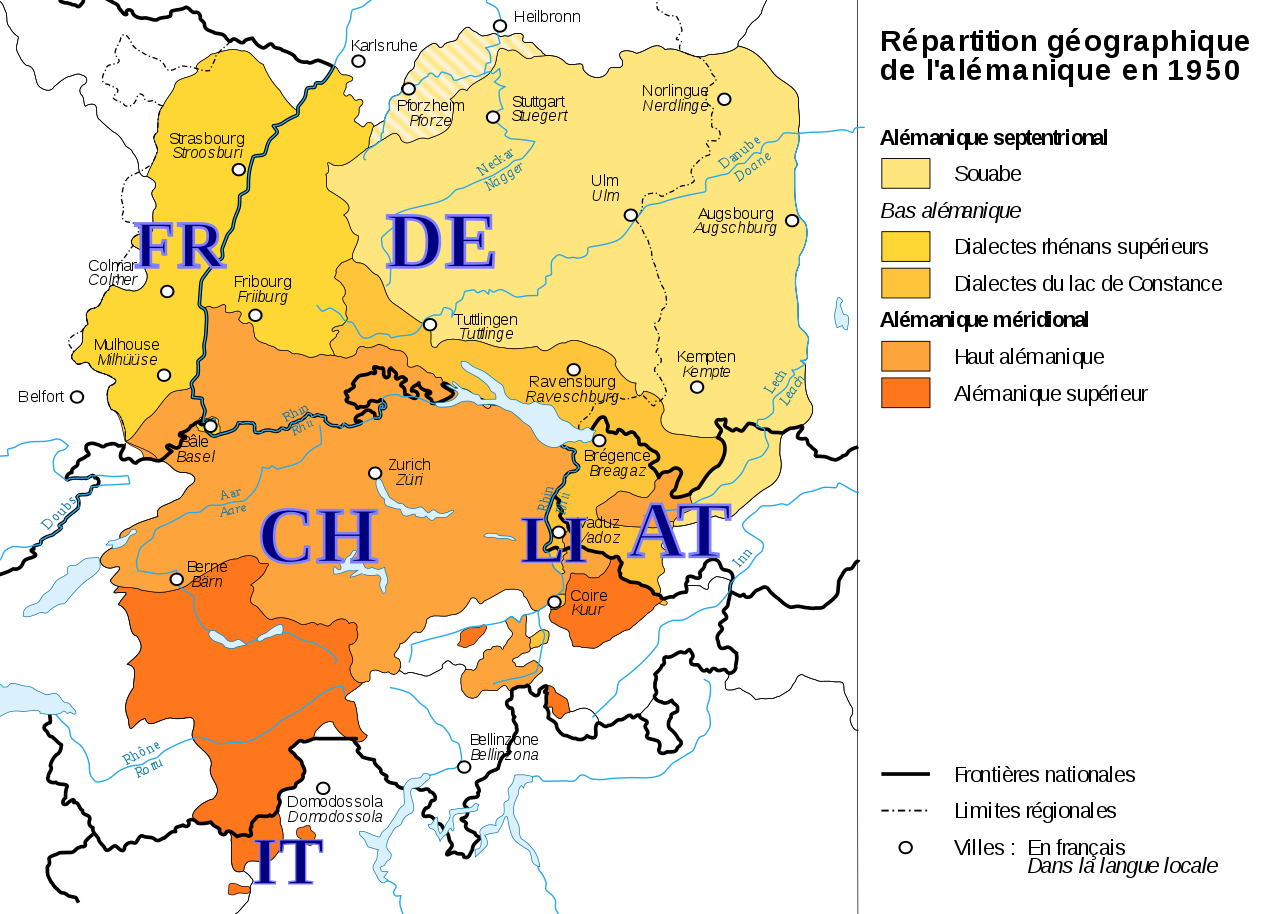
Français : Aire de diffusion de l'Alémanique, avec les codes des pays. Version en français.
Fichier source: Alemannic_language_location_map_in_1950-fr.svg Alemannisch : Dr alemannisch Sprochruum, mit de Lander-Codes. Franzeescha Version.
Quelle-Datei: Alemannic_language_location_map_in_1950-fr.svg English: The Alemannic speech area, with the country-codes. French version. Source: Alemannic_language_location_map_in_1950-fr.svg |
| Date | |
| Source | Own work |
| Author | MlibFR |
| Other versions |
PNG:
PNG:
SVG:
SVG: SVG:
|


Licensing[edit]
I, the copyright holder of this work, hereby publish it under the following license:
This file is licensed under the Creative Commons Attribution-Share Alike 4.0 International license.
- You are free:
- to share – to copy, distribute and transmit the work
- to remix – to adapt the work
- Under the following conditions:
- attribution – You must give appropriate credit, provide a link to the license, and indicate if changes were made. You may do so in any reasonable manner, but not in any way that suggests the licensor endorses you or your use.
- share alike – If you remix, transform, or build upon the material, you must distribute your contributions under the same or compatible license as the original.
File history
Click on a date/time to view the file as it appeared at that time.
| Date/Time | Thumbnail | Dimensions | User | Comment | |
|---|---|---|---|---|---|
| current | 19:40, 12 October 2017 | | 1,400 × 1,000 (243 KB) | MlibFR (talk | contribs) | User created page with UploadWizard |
You cannot overwrite this file.
File usage on Commons
The following 22 pages use this file:
- User:Chumwa/OgreBot/Travel and communication maps/2017 October 11-20
- File:AlemBeispielsatz Orte1 de.svg
- File:AlemByspylsatz Ort1.svg
- File:Alemannic-Dialects-Map-English.png
- File:Alemannic-Dialects-Map-English.svg
- File:Alemannic-Dialects-Map-French.png
- File:Alemannic-Dialects-Map-French.svg
- File:Alemannic-Dialects-Map-German.png
- File:Alemannic-Dialects-Map-German.svg
- File:Alemannic-Dialects-Map-Hungarian.png
- File:Alemannic-Dialects-Map-Hungarian.svg
- File:Alemannic language location map in 1950-de.svg
- File:Alemannic language location map in 1950-fr.svg
- File:Alemannic language location map in 1950 with countries-fr.svg
- File:Alemannisch-korrigiert.png
- File:Alemannisch.png
- File:Alemannisch blank.png
- File:Alemannisch hu.png
- File:Charte Alemannisch korrigiert2.svg
- File:Charte Alemannisch korrigiert 4.svg
- File:Charte Alemannisch korrigiert 5.svg
- Template:Alemannic-dialects-maps
File usage on other wikis
The following other wikis use this file:
- Usage on als.wikipedia.org